
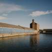
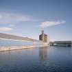
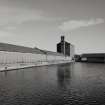
Dundee, Camperdown Street, Victoria Dock, South Shed


Shed (Period Unassigned)
Site Name Dundee, Camperdown Street, Victoria Dock, South Shed
Classification Shed (Period Unassigned)
Alternative Name(s) Consortium Conservation Ltd; Dundee Harbour; Port Of Dundee; River Tay; Firth Of Tay
Canmore ID 232828
Site Number NO43SW 89.04
NGR NO 41137 30485
Datum OSGB36 - NGR
Permalink http://canmore.org.uk/site/232828


- Council Dundee, City Of
- Parish Dundee (Dundee, City Of)
- Former Region Tayside
- Former District City Of Dundee
- Former County Angus
NO43SW 89.04 41137 30485

