Scheduled Maintenance
Please be advised that this website will undergo scheduled maintenance on the following dates: •
Tuesday 3rd December 11:00-15:00
During these times, some services may be temporarily unavailable. We apologise for any inconvenience this may cause.
Lochan Nan Rath, Moss Of Achnacree
Cairn (Bronze Age)
Site Name Lochan Nan Rath, Moss Of Achnacree
Classification Cairn (Bronze Age)
Alternative Name(s) The Baron's Cairn
Canmore ID 23230
Site Number NM93NW 16
NGR NM 92197 35341
Datum OSGB36 - NGR
Permalink http://canmore.org.uk/site/23230
- Council Argyll And Bute
- Parish Ardchattan And Muckairn (Argyll And Bute)
- Former Region Strathclyde
- Former District Argyll And Bute
- Former County Argyll
NM93NW 16 9219 3534
(NM 9219 3534) Cairn (NR)
(Undated) OS annotation.
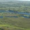
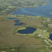
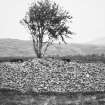
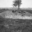
Known as 'The Baron's Cairn', this cairn stands in a hollow on the Moss of Achnacree and is completely free of peat. It measures 19.2 metres north to south by 18.3m transversely and is 2.3 metres in height. The shallow depressions visible on the top and flanks may be the result of Smith's exploratory trenching in about 1870 when he established that the cairn was not chambered. It is probable that any primary burials remain undisturbed.
R A Smith 1870-2; RCAHMS 1975.
As described. Name, 'The Baron's Cairn' was not confirmed locally.
Surveyed at 1:2500 scale.
Visited by OS (DWR) 28 October 1971.
Field Visit (April 1967)
NM 921 353. This cairn, known as 'The Baron's Cairn', is situated at a hight of about 15m OD on the Moss of Achnacree, 135m E of the S end of Lochan nan Rath. Measuring 19.2m north to south by 18.3m transversely and 2.3m in height, it stands in a hollow in the moss and is itself completely free of peat. Several shallow depressions visible in the top and flanks may represent the exploratory trenching done by Smith about 1870 (Loch Etive, 169), when he established that the cairn was not chambered. He makes no mention of internal structures, and it is probable that any primary burials remain undisturbed.
RCAHMS 1975, visited April 1967.


