
Pricing Change
New pricing for orders of material from this site will come into place shortly. Charges for supply of digital images, digitisation on demand, prints and licensing will be altered.
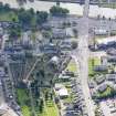
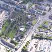
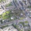
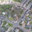
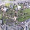
Dumfries, St Michael Street, St Michael's Churchyard, Main Gate


Burial Ground (Post Medieval), Burial Ground (Medieval)(Possible), Churchyard (18th Century), Gate (18th Century)
Site Name Dumfries, St Michael Street, St Michael's Churchyard, Main Gate
Classification Burial Ground (Post Medieval), Burial Ground (Medieval)(Possible), Churchyard (18th Century), Gate (18th Century)
Canmore ID 232277
Site Number NX97NE 18.02
NGR NX 97545 75699
Datum OSGB36 - NGR
Permalink http://canmore.org.uk/site/232277


- Council Dumfries And Galloway
- Parish Dumfries
- Former Region Dumfries And Galloway
- Former District Nithsdale
- Former County Dumfries-shire
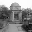
Photographic Survey (24 April 1959)
Photographs by the Scottish National Buildings Record in April 1959.
Photographic Survey (November 1964)
Photographic survey by the Scottish National Buildings Record/Ministry of Work in November 1964.
Note
Burial ground depicted on the 1st edition of the OS 6-inch map (1861).
Information from HES (C DeDeo) 4 March 2024

