
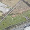
Antonine Wall, Military Way


Frontier Defence (Roman), Roman Road (Roman)
Site Name Antonine Wall, Military Way
Classification Frontier Defence (Roman), Roman Road (Roman)
Alternative Name(s) Bemulie Fort; Cadder Church; Torrance Roundabout
Canmore ID 232215
Site Number NS67SW 45.03
NGR NS 62210 72786
NGR Description NS 6000 7213 to NS c.6500 7393
Datum OSGB36 - NGR
Permalink http://canmore.org.uk/site/232215


- Council East Dunbartonshire
- Parish Cadder (Strathkelvin-du)
- Former Region Strathclyde
- Former District Strathkelvin
- Former County Lanarkshire
NS67SW 45.03 6000 7213 to c. 6500 7393
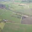
The remains of the Causeway are very distinct between Bemulie (sic) fort (Balmuildy fort NS57SE 12) and Cadder church (NS67SW 28) 27 paces from the Wall (Stuart 1852).
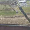
NS 6000 7213 to NS 6031 7224 The modern road is possibly on the line of the Military Way (Macdonald 1934).
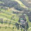
NS 6081 7245 The Military Way and the Ditch are well preserved in Cawder Wood (Horsley 1732).
NS 6000 7213 to NS 6100 7248 No indications of the Military Way were found in this sector.
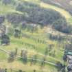
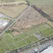
NS 6100 7252 to NS 6200 7274 Nothing pertaining to the Military Way or its loop-roads was noted, and no significant air photographic detail was found for this sector.
NS 6114 7259 The base of the Wall and the Military Way (at two points) were found by excavation about 1913 (Macdonald 1915).
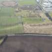
NS 6170 7245 to NS 6184 7250 and NS 6178 7243 to NS 6184 7250 The course and bifurcation of the Military Way was determined by excavations at and around Cadder fort (NS67SW 16), 1929-31 (Macdonald 1934).
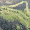
NS 6184 7250 to NS 6200 7266 In favourable conditions the Military Way can be seen descending the slope at a slight angle (Macdonald 1934).
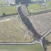
NS 6200 7266 to NS 6236 7278
Causeway (?) 20ft to 40ft from the centre of the fosse [Ditch]. Similar foundations found throughout the parish (Cadder) (ONB 1858).
No extant portion of the Military Way is visible in the tree belt. Macdonald's (1934) course is accepted.
NS 6217 7272 Slight remains of the Wall, much defaced in a strip of plantation. (Should read Military Way?) (ONB 1858).
NS 6221 7273 The stone bottoming of the Military Way may often be seen protruding through the surface of the tree belt (Macdonald 1934).
NS 6240 7277 to NS 6300 7282 Kirkintilloch Road must in part overlie the Military Way (Macdonald 1934) (Horsley (1732) also refers to this).
NS c.6300 7287 to NS c. 6419 7350 Causeway (?) 20ft to 40ft from the centre of the fosse [Ditch]. Similar foundations found throughout the parish (Cadder) Causewayed road 36ft (?) wide and 200yds long, 20 links from the Ditch, found in 1828 (ONB 1858).
No indications of the Military Way have been found.
NS c.6450 7375 to NS c.6500 7393 Roy (1793) gives no position line here, and there are no recorded subsequent discoveries of the Wall or the Military Way.
Information from OS 1980
J Horsley 1732; G Macdonald 1915, 1934; ONB 1858; W Roy 1793; R Stuart 1852
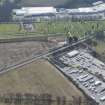
NS 6274 7284 Excavation in advance of the construction of a water pipe-line found the stone base of the Rampart was partially preserved (NS67SW 45.00). No certain trace of the Military Way was identified. A flat-bottomed ditch identified at the S end of the trench, c.15m S of the Rampart, may be the remains of a ditch flanking this road, although alternatively the feature may be a field boundary or drainage feature of comparatively recent origin.
A Dunwell and G Coles 1998.
Length from NS c. 61804 72655 and NS c. 61939 72597 to NS c. 62356 72800 scheduled as 'Antonine Wall and Military Way, 515m N of Crofthead Cottage... approximately 575m in length...'
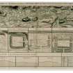
[Index no. 7551: location map supplied. See also ND67SW 45.00].
Information from Historic Scotland, scheduling document dated 3 June 2011.
Antiquarian Observation (1732)
NS 6081 7245 The Military Way and the Ditch are well preserved in Cawder Wood (Horsley 1732).
Antiquarian Observation (1732)
NS 6240 7277 to NS 6300 7282 Kirkintilloch Road must in part overlie the Military Way (Macdonald 1934) (Horsley (1732) also refers to this).
Antiquarian Observation (1852)
The remains of the Causeway are very distinct between Bemulie (sic) fort (Balmuildy fort NS57SE 12) and Cadder church (NS67SW 28) 27 paces from the Wall (Stuart 1852).
Antiquarian Observation (1858)
NS 6200 7266 to NS 6236 7278
Causeway (?) 20ft to 40ft from the centre of the fosse [Ditch]. Similar foundations found throughout the parish (Cadder) (ONB 1858).
Antiquarian Observation (1858)
NS c.6300 7287 to NS c. 6419 7350 Causeway (?) 20ft to 40ft from the centre of the fosse [Ditch]. Similar foundations found throughout the parish (Cadder) Causewayed road 36ft (?) wide and 200yds long, 20 links from the Ditch, found in 1828 (ONB 1858).
Antiquarian Observation (1858)
NS 6217 7272 Slight remains of the Wall, much defaced in a strip of plantation. (Should read Military Way?) (ONB 1858).
Excavation (1913)
NS 6114 7259 The base of the Wall and the Military Way (at two points) were found by excavation about 1913 (Macdonald 1915).
Excavation (1929 - 1931)
NS 6170 7245 to NS 6184 7250 and NS 6178 7243 to NS 6184 7250 The course and bifurcation of the Military Way was determined by excavations at and around Cadder fort (NS67SW 16), 1929-31 (Macdonald 1934).
Field Visit (1934)
NS 6000 7213 to NS 6031 7224 The modern road is possibly on the line of the Military Way (Macdonald 1934).
Field Visit (1934)
NS 6221 7273 The stone bottoming of the Military Way may often be seen protruding through the surface of the tree belt (Macdonald 1934).
Field Visit (1934)
NS 6184 7250 to NS 6200 7266 In favourable conditions the Military Way can be seen descending the slope at a slight angle (Macdonald 1934).
Field Visit (1980)
NS 6000 7213 to NS 6100 7248 No indications of the Military Way were found in this sector.
Field Visit (1980)
NS 6100 7252 to NS 6200 7274 Nothing pertaining to the Military Way or its loop-roads was noted, and no significant air photographic detail was found for this sector.
Field Visit (1980)
NS 6200 7266 to NS 6236 7278
No extant portion of the Military Way is visible in the tree belt. Macdonald's (1934) course is accepted.
Field Visit (1980)
NS c.6300 7287 to NS c. 6419 7350 No indications of the Military Way have been found.
Field Visit (1980)
NS c.6450 7375 to NS c.6500 7393 Roy (1793) gives no position line here, and there are no recorded subsequent discoveries of the Wall or the Military Way.
Excavation (1998)
NS 6274 7284 Excavation in advance of the construction of a water pipe-line found the stone base of the Rampart was partially preserved (NS67SW 45.00). No certain trace of the Military Way was identified. A flat-bottomed ditch identified at the S end of the trench, c.15m S of the Rampart, may be the remains of a ditch flanking this road, although alternatively the feature may be a field boundary or drainage feature of comparatively recent origin.
A Dunwell and G Coles 1998.

