
Pricing Change
New pricing for orders of material from this site will come into place shortly. Charges for supply of digital images, digitisation on demand, prints and licensing will be altered.
Upcoming Maintenance
Please be advised that this website will undergo scheduled maintenance on the following dates:
Thursday, 9 January: 11:00 AM - 3:00 PM
Thursday, 23 January: 11:00 AM - 3:00 PM
Thursday, 30 January: 11:00 AM - 3:00 PM
During these times, some functionality such as image purchasing may be temporarily unavailable. We apologise for any inconvenience this may cause.
Lismore, Dun Cuilein


Dun (Later Prehistoric)
Site Name Lismore, Dun Cuilein
Classification Dun (Later Prehistoric)
Canmore ID 23106
Site Number NM84SW 2
NGR NM 8250 4018
Datum OSGB36 - NGR
Permalink http://canmore.org.uk/site/23106


- Council Argyll And Bute
- Parish Lismore And Appin (Argyll And Bute)
- Former Region Strathclyde
- Former District Argyll And Bute
- Former County Argyll
NM84SW 2 8250 4018.
(NM 8250 4018) Dun Cuilein (NR)
OS 1:10,000 map, (1976)
On the highest part of a ridge of outcrop rock, are the slight remains of a dun. It measured about 25 by 14 metres internally. The wall is now reduced to a spread of rubble whose width ranges from 2 to 3 metres in the north to less than 1 metre in the south.
A single stretch of outer facing stones survives on the west side. Visible below the dun on the east side are two detached outer facing stones, probably the last visible remnants of an outer wall which enclosed the natural shelf on that side. A secondary earthen bank which runs across the south end is the only feature of the interior.
RCAHMS 1975, visited 1968.
As described.
Surveyed at 1:2500.
Visited by OS (RD) 29 November 1971.
Field Visit (9 July 1943)
This site was included within the RCAHMS Emergency Survey (1942-3), an unpublished rescue project. Site descriptions, organised by county, vary from short notes to lengthy and full descriptions and are available to view online with contemporary sketches and photographs. The original typescripts, manuscripts, notebooks and photographs can also be consulted in the RCAHMS Search Room.
Information from RCAHMS (GFG) 10 December 2014.
Field Visit (May 1968)
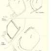
NM 824 401. Some slight remains of a dun (Fig. 64, plan), which has measured about 25 m by 14 m internally, are situated on the highest part of a ridge of rock outcrop 180 m SW of Frackersaig farmhouse. The wall is reduced to a spread of rubble 2 m to 3 m in width on the N, and less than I m in width on the S side. A single stretch of outer facing-stones survives on the W. Two detached outer facing-stones, visible below the dun on the E side, are probably all that remains of an outer wall which enclosed the natural shelf on this side. The only feature in the interior of the dun is a secondary earthen bank which runs across the S end.
RCAHMS 1975, visited May 1968.
Measured Survey (1968)
Surveyed with alidade and plane-table at 1mm:1ft. Redrawn in ink and published at the reduced scale of 1:1000 (RCAHMS 1975, fig. 64).
Note (2 December 2014 - 18 May 2016)
This small fortification occupies the summit of a rocky hillock, enclosing an irregular area measuring 25m from NNE to SSW by 14m transversely (0.03ha). Its wall has been reduced to a spread of rubble between 2m and 3m thick, though a short run of outer facing-stones survive on the NW. A second run on the SE probably belongs to an outer wall taking in a terrace below the summit on the NE, though little else of it is now visible. Apart from an earthen bank cutting across SW end of the enclosure, the interior is featureless.
Information from An Atlas of Hillforts of Great Britain and Ireland – 18 May 2016. Atlas of Hillforts SC2593

