
Balure, Carn Ban


Burial Cairn (Bronze Age)
Site Name Balure, Carn Ban
Classification Burial Cairn (Bronze Age)
Alternative Name(s) Balure 1; West
Canmore ID 23101
Site Number NM84SE 6
NGR NM 89361 41398
Datum OSGB36 - NGR
Permalink http://canmore.org.uk/site/23101


- Council Argyll And Bute
- Parish Ardchattan And Muckairn (Argyll And Bute)
- Former Region Strathclyde
- Former District Argyll And Bute
- Former County Argyll
NM84SE 6 8936 4139
(NM 8936 4139) Carn Ban (NR)
OS 1:10,000 map, (1976).
See also NM84SE 7 and NM84SE 8.
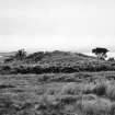
The most westerly of a group of three cairns [NM84SE 6, NM84SE 7, NM84SE 8 ], Carn Ban measures about 23 metres in diameter and 3 metres in height. A shallow pit has been sunk in the top, but otherwise the cairn appears to be undisturbed.
RCAHMS 1975, visited April 1967.
As described, but average height is 2 metres.
Surveyed at 1:2500.
Visited by OS (RD) 8 November 1971.
Field Visit (April 1967)
About 750 m SW of Balure farmhouse there is a group of three cairns, situated on a bleak heather-covered moss at a height of about 12 m OD.
(1) NM 893 414. The most westerly of the group, which has the name Carn Ban, measures about 23 m in diameter and 3 m in height. A shallow pit has been sunk in the top, but otherwise the cairn appears to be undisturbed.
RCAHMS 1975, visited April 1967.

