
Lismore, Castle Coeffin


Cultivation Remains (Post Medieval), Fort (Prehistoric)
Site Name Lismore, Castle Coeffin
Classification Cultivation Remains (Post Medieval), Fort (Prehistoric)
Canmore ID 23088
Site Number NM84SE 15
NGR NM 8549 4387
Datum OSGB36 - NGR
Permalink http://canmore.org.uk/site/23088


- Council Argyll And Bute
- Parish Lismore And Appin (Argyll And Bute)
- Former Region Strathclyde
- Former District Argyll And Bute
- Former County Argyll
NM84SE 15 8549 4387
(NM 8549 4387) Fort (NR)
OS 1:10,000 map, (1976)
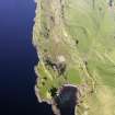
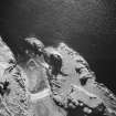
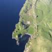
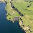
The slight remains of what has probably been a stone-walled fort stand on the level summit of a rocky ridge 190 metres NE of Castle Coeffin (NM84SE 2). Except on the NE where access across gentle grassy slopes is easy, the vertical rock faces 7.6 metres in height afford strong natural protection. A sub-rectangular area, measuring about 80 metres NE to SW by 36 metres transversely has been defended by a single stone wall drawn in a shallow arc across the ridge. The remains of this wall can still be seen on the NE barring the line of easiest access. It survives for a distance of 33 metres as a ragged, stony bank averaging 3.7 metres in width and 0.5 metres in height. A gap 2.4 metres wide near its mid-point probably indicates the position of the entrance. The whole of the interior appears to have been subject to intensive cultivation in comparatively recent times.
RCAHMS 1975, visited May 1968.
As described.
Surveyed at 1/2500.
Visited by OS (DWR) 11 November 1971.
Field Visit (May 1968)
NM 854 438. On the level summit of a rocky ridge 90 m NE of Castle Coeffin there are the last vestiges of what has probably been a stone-walled fort. Easy access to the summit can be gained across gentle grassy slopes on the NE, but on all other sides steep or vertical rock-faces 7.6 m in height afford strong natural protection.
A sub-rectangular area measuring about 80 m from NE to SW by 36 m transversely has been defended by a single stone wall, the mutilated remains of which can still be seen on the NE, where it was drawn in a shallow arc across the spine of the ridge, barring the line of easiest access. Here it survives for a distance of 33 m as a ragged stony bank 3·7 m in average width and 0·5 m high, a gap 2·4 m wide near its mid-point presumably indicating the position of the entrance. No traces of a wall have been preserved along the flanks or at the SW end of the ridge, but whether this is because the defences have been completely destroyed on those sides, or because the strong natural protection was deemed sufficient, cannot be determined without excavation. The whole of the interior appears to have been subject to intensive cultivation in comparatively recent times.
RCAHMS 1975, visited May 1968
Note (2 December 2014 - 4 August 2016)
This fort occupies the SW end of a low ridge immediately W of Portcastle. Girt with cliffs everywhere except the NE, a sub-rectangular area measuring 80m from NNE to SSW by 36m transversely (0.27ha) is cut off by a single wall drawn in a gentle arc across its level summit. The wall is reduced to a stony bank 3.7m in thickness by 0.5m in height, and a gap midway along its line is possibly the entrance. The whole of the interior has been cultivated in curvilinear rigs.
Information from An Atlas of Hillforts of Great Britain and Ireland – 04 August 2016. Atlas of Hillforts SC2591

