
Kelso, Cauld


Weir (Medieval)
Site Name Kelso, Cauld
Classification Weir (Medieval)
Alternative Name(s) River Tweed; Kelso Caul Or Weir; Wooden Anna; Wooden Mill; Mayfield Riverside Walk
Canmore ID 230628
Site Number NT73SW 283
NGR NT 72403 34130
Datum OSGB36 - NGR
Permalink http://canmore.org.uk/site/230628


- Council Scottish Borders, The
- Parish Kelso
- Former Region Borders
- Former District Roxburgh
- Former County Roxburghshire
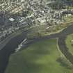
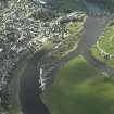
Remnants of a stone-built weir or 'cauld' can be seen running across the River Tweed, immediately above its confluence with the River Teviot. The cauld is about 400m in length, cutting diagonally across the river. Its date is difficult to determine, but parts may be contemporary with the monastic mill which stood near Hogarth's Mill. The cauld, which would have been used to funnel water toward the mill lade, is shown on a drawing of Kelso published by John Slezer in about 1693. John Wood's 1823 'Town Plan of Kelso' shows the cauld running across the river to the site of the medieval mill.
Text prepared by RCAHMS as part of the Accessing Scotland's Past project
NT73SW 283 72403 34130
Cauld [NAT]
OS 1:10,000 map, 1993.
For (associated) Wooden Mill, see NT73SW 116.
The 1993 edition of the OS 1:10,000 map depicts this structure as spanning the main channel of the River Tweed diagonally between the Mayfield Riverside Walk (at NT 7320 3370) and a point (NT 7333 3374) near the SW end of the island of Wooden Anna. It thus presumably served to divert water to the SE of Wooden Anna and into the channel that supplies Wooden Mill (NT73SW 116).
Information from RCAHMS (RJCM), 1 February 2006.
Project (2007)
This project was undertaken to input site information listed in 'Civil engineering heritage: Scotland - Lowlands and Borders' by R Paxton and J Shipway, 2007.
Publication Account (2007)
This weir across the Tweed at Kelso is believed to date from ca.1250 and may have been constructed by the
monks of Kelso Abbey. It is built of sandstone masonry, about 1300 ft long and 5 ft high, and crosses the river at an angle for the purpose of diverting water into the mill lade. The downstream face is a varying slope meeting an apron of stones held in a framework of timber baulks which is accessible at its east end only through Hogarth’s Mill. The cauld is best seen from Chalkheugh Terrace. A dramatic 17th century view of it was drawn by Slezer. Part of the medieval mill can be seen spanning the lade at the rear of Hogarth’s mill.
R Paxton and J Shipway 2007
Reproduced from 'Civil Engineering Scotland: Lowlands and Borders' with kind permission fromThomas Telford Publishers.

