
Following the launch of trove.scot in February 2025 we are now planning the retiral of some of our webservices. Canmore will be switched off on 24th June 2025. Information about the closure can be found on the HES website: Retiral of HES web services | Historic Environment Scotland
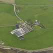
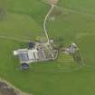
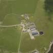
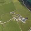
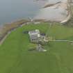
Hall Of Tankerness


House (16th Century), Merchants House (17th Century)
Site Name Hall Of Tankerness
Classification House (16th Century), Merchants House (17th Century)
Canmore ID 229541
Site Number HY50NW 81
NGR HY 52370 08893
Datum OSGB36 - NGR
Permalink http://canmore.org.uk/site/229541


- Council Orkney Islands
- Parish St Andrews And Deerness
- Former Region Orkney Islands Area
- Former District Orkney
- Former County Orkney
HY50NW 81 52370 08893
See also:
HY50NW 52.00 HY 52346 08775 Hall of Tankerness (Farmhouse and Steading)
Field Visit (April 1979)
The house was believed by Clouston to incorporate a very much older building. [R1]
Great house and home farm, centre of the Baikie estate. The home farm is surrounded by a high castellated wall with Gothic niches in it. The house looks east i.e. seawards, and the boundary on this side is a ha-ha (ditch and sunken wall). The style of the home-farm buildings is reflected in the fishing-station OR 45 and the boathouse OR 53.
Information from Orkney SMR (RGL) Apr 79

