
Following the launch of trove.scot in February 2025 we are now planning the retiral of some of our webservices. Canmore will be switched off on 24th June 2025. Information about the closure can be found on the HES website: Retiral of HES web services | Historic Environment Scotland
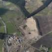
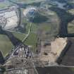
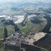
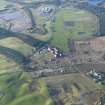
Lanark, Hyndford Road, Lanark Racecourse


Grandstand (19th Century) - (20th Century), Racecourse (Post Medieval), Sports Pavilion (Period Unassigned)
Site Name Lanark, Hyndford Road, Lanark Racecourse
Classification Grandstand (19th Century) - (20th Century), Racecourse (Post Medieval), Sports Pavilion (Period Unassigned)
Alternative Name(s) Pavilion, Grandstand, Information Building
Canmore ID 229415
Site Number NS94SW 85
NGR NS 90400 42682
Datum OSGB36 - NGR
Permalink http://canmore.org.uk/site/229415


- Council South Lanarkshire
- Parish Lanark
- Former Region Strathclyde
- Former District Clydesdale
- Former County Lanarkshire
Race Course [NAT]
OS 1:10,000 map [no date available].
NS94SW 85.00 90400 42682 Lanark Racecourse, Pavilion
NS94SW 85.01 90092 42595 Tollhouse
NS94SW 85.02 90410 42487 Tote Tower

