
Pricing Change
New pricing for orders of material from this site will come into place shortly. Charges for supply of digital images, digitisation on demand, prints and licensing will be altered.
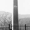
Kilbride, Campbell Of Lerags Cross


Cross (16th Century)
Site Name Kilbride, Campbell Of Lerags Cross
Classification Cross (16th Century)
Canmore ID 22888
Site Number NM82NE 14
NGR NM 85776 25900
Datum OSGB36 - NGR
Permalink http://canmore.org.uk/site/22888


- Council Argyll And Bute
- Parish Kilmore And Kilbride
- Former Region Strathclyde
- Former District Argyll And Bute
- Former County Argyll
NM82NE 14 85776 25900
(NM 85776 25900) Cross (NR) (Restored)
OS 1:10,000 map, (1977)
This cross, 3.13 metres high and 0.69 metres across the arms, was re-erected on its present site in 1926, having lain in pieces in Kilbride churchyard for over 200 years. According to local tradition, it originally stood beside an old road running SE from the coast at Gallanach (NM 82 27) to the Lowlands, which crosses the modern road about 200 metres north of the entrance to the churchyard.
The cross, which has been carved from a single block of greenish schist is profusely inscribed and was originally erected by Archibald Campbell of Lerags in 1516.
J R Allen 1881; J S Richardson 1927; RCAHMS 1975, visited June 1971.
Information from G Livock, (photo), 1940.
As described.
Surveyed at 1:2500 scale.
Visited by OS (R D) 8 September 1971.

