
Pinmore, Railway Viaduct


Railway Viaduct (19th Century)
Site Name Pinmore, Railway Viaduct
Classification Railway Viaduct (19th Century)
Alternative Name(s) Kinclair Viaduct; Pinmore Viaduct; Kinclaer Viaduct
Canmore ID 228340
Site Number NX29SW 36
NGR NX 20110 91110
Datum OSGB36 - NGR
Permalink http://canmore.org.uk/site/228340


- Council South Ayrshire
- Parish Girvan
- Former Region Strathclyde
- Former District Kyle And Carrick
- Former County Ayrshire
NX29SW 36 20110 91110
Viaduct [NAT] (centred NX 20116 91120)
OS (GIS) AIB, July 2006.
Location formerly entered as NX 20116 91053 and placed within Colmonell parish.
Extends into Colmonell parish.
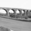
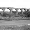
Kinclaer (Pinmore) Viaduct: this stone structure comprised eleven arches and had a maximum height of 80ft [24.4m]. It was one of three heavy engineering works at the Girvan [N] end of the Girvan and Portpatrick Junction Rly, the others being the Glendoune cutting [NX19NE 181] and the Pinmore tunnel [NX19SE 42]. It was completed by the end of summer 1874.
D L Smith 1969.
(Location cited as NX 202 912). Kniclaer Viaduct: opened 1877 by the Girvan and Portpatrick Rly. A handsome 10-span viaduct on a curve, with semicircular arches. The arch rings are of dressed stone, with coursed-rubble piers and random rubble spandrels.
J R Hume 1976.
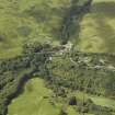
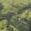
This viaduct carries the Girvan-Stranraer portion of the Glasgow-Stranraer (main) line of the (former) Glasgow and South Western Rly over both sides of a pronounced loop in the A714 public road 0.9km S of Pinmore Station (NX29SW 35). The line here climbs up the W side of the valley of the Water of Assel, a tributary of the River Stinchar. It does not cross the Water of Assel as such.
The viaduct is curving on plan, being bowed towards the W, and is depicted, but not noted, on the 1982 edition of the OS 1:10,000 map. It remains in regular use by passenger traffic.
The location assigned to this record denotes the approximate midpoint of the viaduct. The available map evidence indicates that it extends from from NX c. 20136 91264 to NX c. 20121 91029. Although the greater part of its length falls within the parish of Girvan, the S end extends into that of Colmonell.
Information from RCAHMS (RJCM), 12 July 2006.

