
Following the launch of trove.scot in February 2025 we are now planning the retiral of some of our webservices. Canmore will be switched off on 24th June 2025. Information about the closure can be found on the HES website: Retiral of HES web services | Historic Environment Scotland
Edinburgh, Rutland Place


Pillbox (20th Century)
Site Name Edinburgh, Rutland Place
Classification Pillbox (20th Century)
Alternative Name(s) Edinburgh Defence Scheme; Princes Street, West End
Canmore ID 227627
Site Number NT27SW 3477
NGR NT 24666 73662
Datum OSGB36 - NGR
Permalink http://canmore.org.uk/site/227627

- Council Edinburgh, City Of
- Parish Edinburgh (Edinburgh, City Of)
- Former Region Lothian
- Former District City Of Edinburgh
- Former County Midlothian
NT27SW 3477 24666 73662
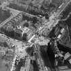
A pillbox, constructed of brick and concrete was situated on the S side of Rutland Place, outside the Rutland Hotel. The pillbox was demolished some time during 1944-5. The external walls had been camouflaged with windows to look like an occupied building.
The structure formed part of the Inner Defence (Red Line) of Edinburgh's defences and was manned by the 6th Battalion Home Guard.
Information from RCAHMS (DE), November 2002

