
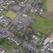
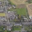
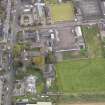
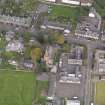
Invergowrie, Errol Road, Invergowrie Primary School


School (Period Unassigned)
Site Name Invergowrie, Errol Road, Invergowrie Primary School
Classification School (Period Unassigned)
Canmore ID 226936
Site Number NO33SW 135
NGR NO 34626 30343
Datum OSGB36 - NGR
Permalink http://canmore.org.uk/site/226936


- Council Perth And Kinross
- Parish Longforgan (Perth And Kinross)
- Former Region Tayside
- Former District City Of Dundee
- Former County Perthshire
Archaeological Evaluation (4 August 2010 - 6 August 2010)
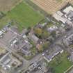
This report represents the results of an archaeological evaluation undertaken by AOC Archaeology Group on the site of a proposed extension to Invergowrie Primary School, Invergowrie, Perth and Kinross. The archaeological evaluation was originally designed around a 6% trenching sample (900 m²). However, approximately one third of the site was unavailable for evaluation at this time, as the land parcel was in the process of being purchased by Perth and Kinross Council. This led to a revised trenching sample (720 m²) being undertaken, after consultation with Perth and Kinross Heritage Trust (PKHT). No archaeologically significant finds or features were encountered, although there was evidence of recent activity in the form of rubble field drains, modern pits and post-holes and two linear features of unknown function. A cinder path was also revealed running east to west along the northern half of the site.
Information from Oasis (aocarcha1-81813) 17 January 2012
Archaeological Evaluation (19 October 2011)
An archaeological evaluation was undertaken by AOC Archaeology Group on the site of a proposed extension to Invergowrie Primary School, Invergowrie, Perth and Kinross. This work follows on from a previous evaluation carried out in 2010 and was on ground which at that time was unavailable for evaluation. No archaeologically significant finds or features were encountered.
Archive: RCAHMS
Funder: Perth and Kinross Council
AOC Archaeology Group, 2011
Information also reported in Oasis (aocarcha1-112248) 2 December 2011

