
Barr Leathan, Mull


Standing Stone (Prehistoric)
Site Name Barr Leathan, Mull
Classification Standing Stone (Prehistoric)
Alternative Name(s) Duart; Auchnacraig
Canmore ID 22667
Site Number NM73SW 2
NGR NM 7259 3425
Datum OSGB36 - NGR
Permalink http://canmore.org.uk/site/22667


- Council Argyll And Bute
- Parish Torosay
- Former Region Strathclyde
- Former District Argyll And Bute
- Former County Argyll
NM73SW 2 7259 3425.
(NM 7259 3425) Standing Stone (NR)
OS 1:10,000 map, (1977)
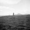
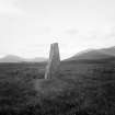
Standing Stone, Barr Leathan: This standing stone, situated in open moorland 900m NNW of Lochdonhead School, has been about 2.5m in height, but now leans distinctly to the W. It is rectangular in section, measures 0.8m by 0.7m at the base and tapers on the NE and SW sides to a flat top.
RCAHMS 1980, visited 1975.
This standing stone, dimensions as given by the RCAHMS (1980), is situated in a hollow on the E end of the outcrop from which it has been quarried. Probing reached rock near the base of the stone about 0.3m below the turf.
Resurveyed at 1:2500.
Visited by OS (RD) 17 May 1972.
Field Visit (23 July 1943)
This site was recorded as part of the RCAHMS Emergency Survey, undertaken by Angus Graham and Vere Gordon Childe during World War 2. The project archive has been catalogued during 2013-2014 and the material, which includes notebooks, manuscripts, typescripts, plans and photographs, is now available online.
Information from RCAHMS (GF Geddes) 3 December 2014.

