
Hunthall


Enclosure(S) (Post Medieval), Field System(S) (Medieval) - (Post Medieval), Hut (Post Medieval)(Possible), Rig And Furrow (Medieval) - (Post Medieval), Track (Medieval) - (Post Medieval)
Site Name Hunthall
Classification Enclosure(S) (Post Medieval), Field System(S) (Medieval) - (Post Medieval), Hut (Post Medieval)(Possible), Rig And Furrow (Medieval) - (Post Medieval), Track (Medieval) - (Post Medieval)
Canmore ID 226651
Site Number NN90NE 46
NGR NN 9639 0553
Datum OSGB36 - NGR
Permalink http://canmore.org.uk/site/226651


- Council Perth And Kinross
- Parish Glendevon
- Former Region Tayside
- Former District Perth And Kinross
- Former County Perthshire
Field Visit (19 June 1998)
NN90NE 46 9639 0553
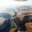
There is an extensive field-system, interspersed with small enclosures, set above the improved haughland of the River Devon on the southern flank of Hillkitty, extending between Hunthall and Cleuch Farm. A trackway runs through part of the field-system and there is a small hut at its southern edge.
The field-system displays evidence of two distinct phases of enclosure, each bounded by earth and stone field-banks, and showing a progressive contraction down to the foot of the slope where the field-banks have been truncated by the improved ground on valley floor. Most of the improved ground lies within the drystone walls shown on the 1st edition of the OS 6-inch map (Perthshire and Clackmannanshire 1866, sheet cxvii). The earlier phase of the field-system comprises a series of turf-banked fields whose southern ends have been truncated by the fields of the second phase of enclosure. The earlier fields are also overlain by several small enclosures (e.g. NN 9629 0557 - trapezoidal enclosure measuring a maximum of 34m by 20m), and there are complex local sequences of remodelled banks and subdivisions (i.e. NN 9644 0558). Although the later fields have also been truncated along their lower edge, they measure on average at least 100m in length from N to S by some 90m transversely. Traces of rig, characterised by slightly curving furrows set about 5m apart, can be seen within the interiors of many of the fields of both phases.
The trackway that winds its way up the SSW flank of Hillkitty through the field-system (see also NN90NE 59, NN 9627 0569) apparently respecting the field-banks, and onto the crest of a SW-facing spur. After crossing some open ground, the hollow trackway runs along the terrace between two enclosures (NN90NE 59, from NN9620 0566 to NN 9628 0571) beyond which it cannot be traced.
The small hut at the southern edge of the field-system (NN 9618 0542) is situated in a small patch of rough ground at the edge of the improved field to the NNE of Hunthall. It measures about 4m from E to W by 3m internally.
Visited by RCAHMS (DCC and SDB) 19 June 1998
Project (1 May 2016 - 12 May 2017)
Archaeological features were identified and mapped from airborne remote sensing sources, such as lidar, historic vertical aerial photographs, and 25cm orthophotographs.
Information from HES (OA) 12 May 2017

