
Dunblane, Kirk Street, Scottish Churches House, Warden's House Block


Residential Building (Period Unassigned), Terraced House (18th Century)
Site Name Dunblane, Kirk Street, Scottish Churches House, Warden's House Block
Classification Residential Building (Period Unassigned), Terraced House (18th Century)
Canmore ID 226177
Site Number NN70SE 78
NGR NN 78237 01371
Datum OSGB36 - NGR
Permalink http://canmore.org.uk/site/226177


- Council Stirling
- Parish Dunblane And Lecropt
- Former Region Central
- Former District Stirling
- Former County Perthshire
NN70SE 78.00 78237 01371
Scottish Churches House [NAT]
OS (GIS) MasterMap, June 2010.
NN70SE 78.01 NN 7820 0141 Trial Excavation
NN70SE 78.02 NN 78238 01380 Entrance Block
NN70SE 78.03 NN 78229 01398 Central Section
Publication Account (1997)
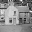
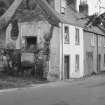
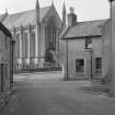
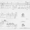
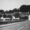
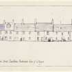
The houses on Kirk Street, fronting onto the cathedral, consist primarily of stone or harled two-storeyed structures, dating to the late eighteenth and early nineteenth centuries. The entire east side of Kirk Street has been built against the steep rise of Holmehill, and has been amalgamated into a series of blocks which together form Scottish Churches House, constructed in the mid eighteenth century. The warden's house block is a two-storey L-shaped plan with a harled and whitewashed surface and one window gable to the street. Incorporated into this block is the former Leighton Manse, constructed slightly later in date, in the domestic Georgian architecture tradition. It now forms the main reception area. Behind this is the chapel which was created from a pre-sixteenth-century cellar, which was thought to have been part of the archdeacon's house figure 6. Partially restored inside, with a new floor, and currently in use as a chapel, it comprises a single vaulted chamber. There are few clues as to the original extent of this building, but the local topography, an extremely narrow ledge or terrace, suggests this may have been an outbuilding of the archdeacon's manse rather than part of a larger complex.
Surrounding the churchyard is a low Victorian wall. Set into it is Riccarton's Stile, which may delineate the frontages or rears of properties that once stood on the cathedral boundary. The churchyard was not used solely as a graveyard. It is known that this area was also used for local fairs and cattle markets. Little is known as to what might lie beneath the kirkyard. There has already been some disturbance here, caused by drainage, gas, water and electricity pipes; and centuries of use as a graveyard will have had a considerable effect on the very earliest archaeological levels. A sizeable workforce would have been needed to build the church. It remains unclear where the earliest settlement in Dunblane was but it is possible that timber buildings to accommodate the workers were ranged around the early church.
Information from ‘Historic Dunblane: The Archaeological Implications of Development’ (1997).

