
Seil, Ellenabeich, Wooden Pier


Pier (Period Unassigned)
Site Name Seil, Ellenabeich, Wooden Pier
Classification Pier (Period Unassigned)
Canmore ID 22615
Site Number NM71NW 3
NGR NM 74120 17178
Datum OSGB36 - NGR
Permalink http://canmore.org.uk/site/22615


- Council Argyll And Bute
- Parish Kilbrandon And Kilchattan
- Former Region Strathclyde
- Former District Argyll And Bute
- Former County Argyll
NM71NW 3.00 7413 1718
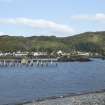
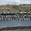
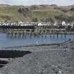
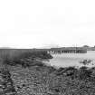
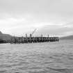
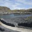
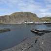
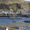
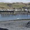
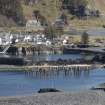
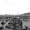
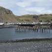
(Location cited as NM 742 172). Mid to late 19th century. A wood-piled pier on a T-plan, extending from a slate rubble approach. Now derelict, though a wood and iron post crane [NM71NW 3.01] survives, inaccessibly, on the pier head.
J R Hume 1977.
Wood piled pier on a T-plan extending from a slate rubble earlier pier constructed for the slate idustry. Wood and iron post crane was sited on the pier head. (J.Hume)
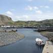
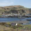
Built to service the the large quarry village of Ellenabeich and by small-boat ferry, the smaller village on Easdale Island. It dates from the period when most places in the west highlands depended on steamers for their trade. (RCAHMS)
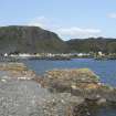
Seil forms part of "the Slate Islands" along with Luing, Easdale and Belnahua, noted from 1631 as suppliers of the finest slates. Urban growth ensured prosperity for Scottish slate's industry for much of the 19th century, although latterly suffering from competition from Welsh slate. (J Butt)
So immense was the output that Ellenabeich, hitherto an island like Easdale, became linked to Seil by a causeway of quarry waste. (FA Walker)

