
Pricing Change
New pricing for orders of material from this site will come into place shortly. Charges for supply of digital images, digitisation on demand, prints and licensing will be altered.
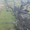
Antonine Wall, Military Way


Frontier Defence (Roman), Roman Road (Roman)
Site Name Antonine Wall, Military Way
Classification Frontier Defence (Roman), Roman Road (Roman)
Canmore ID 226008
Site Number NS77NE 62.02
NGR NS 7690 7765
NGR Description From NS 7500 7719 to NS 8000 7875
Datum OSGB36 - NGR
Permalink http://canmore.org.uk/site/226008


- Council North Lanarkshire
- Parish Cumbernauld
- Former Region Strathclyde
- Former District Cumbernauld And Kilsyth
- Former County Dunbartonshire
NS77NE 62.02 from 7500 7719 to 8000 7875
Trial trenching in the area S of the Roman fort (NS77NE 8) took place in 1974 and 1975 where the construction of a Young Offenders' Institution was proposed. (NS 761 773). Excavation was carried out in the hope of obtaining evidence for a civilian settlement similar to examples found outside many forts along Hadrian's Wall and further evidence on the cobbling excavated in 1932on the SE corner of the fort (Macdonald 1933) which was interpreted as part of a loop road, by which 'through traffic' might avoid passing through the fort itself. No trace was found either of stones forming the bottoming of such a roadway, or of flanking drainage channels. Only further investigation may clarify whether the cobbling on the SE corner of the fort did form part of a Roman roadway or may be of a medieval or later date.
L J F Keppie 1978
NS 7500 7719 to NS 7600 7737 Macdonald apparently confirmed the visible line of the Military Way be excavation for some 700 yards west of Westerwood fort in 1932. Course marked on OS 25 inch 1931 (Macdonald 1934).
NS 7502 7719 to NS 7536 7724 Military Way extant across pasture and scrub, firstly as an agger [causeway] c.5.5m wide and 0.3m high, and then as a terrace of similar width slightly cut into a N facing slope. Turning slightly N, it is lost at the railway embankment. Surveyed at 1:2500. Under Scottish Development Department (Inspectorate of Ancient Monuments) Guardianship from NS 7537 7727 to NS 7515 7720.
NS 7536 7724 to NS 7569 7731 Military Way shows as a grass ride through a forestry plantation. No recognisable agger [causeway], but the stony spread can be probed. Published survey revised. Under Scottish Development Department (Inspectorate of Ancient Monuments) Guardianship.
NS 7569 7731 to NS 7600 7737 No extant remains of Military Way, but faint traces on an RAF vertical aerial photograph (106G/ SCOT/ UK92, frame no 4159, 1946.) support Macdonald's line. Published survey revised.
NS 7600 7737 Military Way resurveyed. No surface trace, but course not in doubt. (see CUCAP aerial photograph 33Q).
NS 7614 7740 to NS 7650 7748 Published survey (OS 25 inch 1972) revised. No surface trace of Military Way. Macdonald's line concurs with RAF aerial photograph markings (106G/ SCOT/ UK10, frame nos. 7094-5, 1946).
Military Way is about 5 chains distant from Ditch east of Westerwood fort ( Horsley 1732).
It is possible that Horsley (1732) Refers to a loop road of the Military Way being c.5 chains from the Ditch, E of the fort.
NS 7615 7740 Macdonald established the line of the Military Way through Westerwoods farm, from E and W, by excavation (see NS77NE 8) and local knowledge (Macdonald 1934).
NS 7650 7748 to NS 7821 7800 The 'Causeway' was said to be plainly visible at Tollpark c.1821 from Arniebog on the W to Garnhall on the E (ONB 1861).
NS 7650 7748 to NS 7658 7750 Publish survey (OS 50 inch 1967) revised. The course of the Military Way is overlaid by a track, to the S of which extensive development landscaping has taken place.
NS 7658 7750 to NS 7800 7792 Macdonald apparently observed the Military Way as a 'slight elevation' in this sector, plotting the course on the OS record 25 inch 1931(Macdonald 1934).
NS 7658 7750 to NS 7700 7769 No surface trace of the Military Way, the course of which is mostly overlaid by a track. RAF aerial photographic evidence obscure (106G/ SCOT/ UK10, frame nos. 7094-5, 1946). Published survey retained.
NS 7700 7769 to NS 7750 7784 No surface trace of Military Way. Macdonald's line seems reasonable and does not appear to have been faulted by evidence of NS 7705 7774. RAF aerial photographic detail is obscure (106G/ SCOT/ UK92 frame nos. 4155-6, 1946.). Published survey correct.
NS 7705 7774 Several sections were cut across the Rampart and Military Way in c.1964 (Keppie and Breeze 1982).
NS 7750 7784 to NS 7800 7792 No trace of Military Way, the course of which is partially overlaid by modern detail. Macdonald's route is generally confirmed by RAF aerial photographs (106G/ SCOT/ UK10 frame no 5075, 1946; F21/82/1236 frame no. 0109, 1955) and OS aerial photographs (65/105 frame nos. 007-8, 1965). Published survey correct.
NS 7800 7792 to NS 7821 7800 Published course (OS 25 inch 1969) revised. There is no surface trace of the Military Way, but its course is well defined on CUCAP aerial photographs (TV 79), RAF aerial photographs (106G/ SCOT /UK10 frame no. 5075, 1946), (F21/ 82/ 1236 frame no. 0109, 1955) and OS aerial photographs (65/ 105 frame nos. 007-8, 1965).
NS 7821 7800 to NS 7841 7807 Surveyed at 25 inch. Distinct terrace of Military Way, c.6m wide and obviously utilized as a later track, crosses pasture field. The line leaving Garnhall to the W is clearly visible on a CUCAP aerial photograph (TV 79), although it shows as only a vague swelling on the ground. There is the faint line in pasture of an old track continuing eastwards from NS 7841 7807 but this has no distinctive form and may be entirely late in date.
The course of the Military Way crossing Red Burn, westwards from Castlecary fort is entirely conjectural, and no recorded evidence of its existence is known.
Detached portions of causeway seen E of Garnhall (ONB 1860).
NS 7822 7815 Excavations in 1977 exposed areas of the Wall base, defined the edges of the Ditch, and located possible traces of the Military Way (Keppie and Millar 1977; Keppie and Breeze 1982).
NS 7841 7807 Detached portions of causeway seen E of Garnhall (ONB 1860).
NS 7900 7835 to NS 8000 7875 The Military Way has only been found at Castlecary fort, but it is reasonable to assume that the modern road parallel to the Wall overlies it.
NS 7904 7835 Excavation at Castlecary fort proved the line of Rampart and Ditch. Military Way was found to run south of and parallel to the modern road. (see NS77NE 24) (Christison 1902-3; Buchanan 1902-3).
Information from OS 1980
D Christison 1902-3; M Buchanan 1902-3; L J F Keppie and H B Millar 1977; L J F Keppie and D J Breeze 1982; J Horsley 1732; G Macdonald 1934; ONB 1861
NS 772 778 The Military Way was found to be at least 6.3m wide, its metalling laid on a raft of turf.
S S Frere 1984.
WESTERWOOD.
The construction of a golf course complex north of Cumbernauld has resulted in the landscaping of wide areas around Westerwood Roman Fort. A corridor comprising the upcast mound, Antonine Wall and Military Way will be left untouched. In December 1986 its N and S limits were determined by excavation. In April 1987 a sample area immediately W of the fort and S of the Military Way was selected for detailed inspection. Some spreads of cobbling and a sequence of stone lined pits may be linked to an agricultural establishment in the period 1450-1600. However, for the most part, ploughing in late medieval and more modern times had removed earlier features. A U-shaped ditch whose fill yielded Roman material ran NS across the site. Other shallow channels could be remnants of a Roman field system. A possible roadway was detected leading S from the fort's S gate. The line of the Antonine Wall and Military Way was also checked in advance of intended pipelaying. The stone base proved to be excellently preserved, at a depth of 0.23m. It was 4.3m wide. The Military Way had been totally removed at this point. Because of the fine state of the Wall base, the pipeline was eventually laid further W, close to a stream bed. The stone base (here somewhat disturbed), the ditch and upcast were again observed in section.
L Keppie 1987.
NS 757 773 to NS 759 774 Excavation W of the fort (NS77NE 8), to determine the line of a corridor to be left unlandscaped along the line of the Wall and Military Way during construction of a golf course, showed that the Military Way , on leaving the fort, ran slightly NW of the expected line to approach close to the Wall just as it does E of the fort. At 70m W of the west gate the road was 5m N of the line shown on the OS maps. Here it consisted of hard-packed stones and gravel with a kerbing of larger cobbles on the S side. South of this ran a U-shaped drainage gully 1m wide and 0.1m deep, bounded on the S by a low clay or turf bank 1.6m wide. The road, c.5m wide, was trace for c.280m further W but was found to be extensively plough-damaged over lost of its length.
S S Frere 1987.
NS 759 773 Further small-scale excavation W of the fort (NS77NE 8) showed that, contrary to deduction made in 1986 (see S S Frere 1987) the Military Way ran on a straight course from the west gate. It was represented by a firm though plough-damaged surface of small stones 5.5m wide. To the south of it the shallow gully previously recorded was seen again on a curving course. North of this was a thin layer of burnt material containing pottery which had probably been spread to support a layer of scattered cobbles above it; to the south some other small boundary-ditches were encountered.
S S Frere 1989.
A series of excavations and watching briefs took place at Westerwood fort (NS77NE 8), Antonine Wall and the Military Way between 1985-87 in order to develop the Westerwood Golf Course. The line of the Antonine Wall, Ditch, upcast Mound and Military Way was established. The Military Way was established 70m W of the fort's W gate, and 5m N of the expected line. The road surface was of small stones and gravel, packed hard, and was edged on its S side by a line of larger cobbles. Adjacent to the S side of road was a U-shaped drainage gully 1m wide and 0.1m deep. Two other areas also established the location of the road. In general, ploughing had served much to reduce the extent of the surviving remains, which seemed to have been quite substantial when Macdonald wrote (1933).
A later trench (an extension off of an earlier trench) also located the Military Way and determined it to be some 5.5m heading E towards the visible causeway across the fort-ditches at the western gate.
Two trenches were cut in 1987 c.100m W of the fort, in advance of a pipe-trench, across the Military Way and stone-base of the Antonine Wall. Only a few cobbles remained of the Military Way, at a depth of 0.3m, giving merely a general indication of the road's alignment.
An early antiquarian speaks of the Military Way at Westerwood as going 'round the Fort on the top of the Ramparts' (Gordon 1726). This has been interpreted as a loop road skirting the fort ditches, for the benefit of 'through traffic'. No evidence for such a road was forthcoming during the excavations in 1986-88.
Sponsor: Historic Scotland
L J F Keppie 1996; G Macdonald 1933; A Gordon 1726
GARNHALL
NS 780 779 Further investigation of two ring features (NS77NE 30) S of the Antonine Wall has established that the more easterly was in origin a relatively modern clay pit, 20m in diameter, cutting the line of the Military Way. The more westerly was stratigraphically earlier than the Wall and the Military Way.
L J F Keppie 1994.
NS 780 779 Continued investigation of the ring-ditch enclosure (NS77NE 30) S of the Antonine Wall. A metalled road ran S to the Military Way, which overlay the ditch on the S side.
L J F Keppie 1995.
NS 780 779 Further small-scale work identified the last of the four post-holes supporting a square tower, and clarified the alignment of a metalled track linking it to the Military Way.
L J F Keppie 1996.
Antiquarian Observation (1732)
Military Way is about 5 chains distant from Ditch east of Westerwood fort ( Horsley 1732).
It is possible that Horsley (1732) Refers to a loop road of the Military Way being c.5 chains from the Ditch, E of the fort.
Antiquarian Observation (1860)
NS 7841 7807 Detached portions of causeway seen E of Garnhall (ONB 1860).
Antiquarian Observation (1861)
NS 7650 7748 to NS 7821 7800 The 'Causeway' was said to be plainly visible at Tollpark c.1821 from Arniebog on the W to Garnhall on the E (ONB 1861).
Excavation (1902)
NS 7900 7835 to NS 8000 7875 The Military Way has only been found at Castlecary fort, but it is reasonable to assume that the modern road parallel to the Wall overlies it.
NS 7904 7835 Excavation at Castlecary fort proved the line of Rampart and Ditch. Military Way was found to run south of and parallel to the modern road. (see NS77NE 24) (Christison 1902-3; Buchanan 1902-3).
Excavation (1931)
NS 7500 7719 to NS 7600 7737 Macdonald apparently confirmed the visible line of the Military Way be excavation for some 700 yards west of Westerwood fort in 1932. Course marked on OS 25 inch 1931 (Macdonald 1934).
Field Visit (1931)
NS 7658 7750 to NS 7800 7792 Macdonald apparently observed the Military Way as a 'slight elevation' in this sector, plotting the course on the OS record 25 inch 1931(Macdonald 1934).
Excavation (1934)
NS 7615 7740 Macdonald established the line of the Military Way through Westerwoods farm, from E and W, by excavation (see NS77NE 8) and local knowledge (Macdonald 1934).
Excavation (1964)
NS 7705 7774 Several sections were cut across the Rampart and Military Way in c.1964 (Keppie and Breeze 1982).
Excavation (1974 - 1975)
Trial trenching in the area S of the Roman fort (NS77NE 8) took place in 1974 and 1975 where the construction of a Young Offenders' Institution was proposed. (NS 761 773). Excavation was carried out in the hope of obtaining evidence for a civilian settlement similar to examples found outside many forts along Hadrian's Wall and further evidence on the cobbling excavated in 1932on the SE corner of the fort (Macdonald 1933) which was interpreted as part of a loop road, by which 'through traffic' might avoid passing through the fort itself. No trace was found either of stones forming the bottoming of such a roadway, or of flanking drainage channels. Only further investigation may clarify whether the cobbling on the SE corner of the fort did form part of a Roman roadway or may be of a medieval or later date.
L J F Keppie 1978
Excavation (1977)
NS 7822 7815 Excavations in 1977 exposed areas of the Wall base, defined the edges of the Ditch, and located possible traces of the Military Way (L J F Keppie and H B Millar 1977; L J F Keppie and D J Breeze 1982).
Field Visit (1980)
NS 7502 7719 to NS 7536 7724 Military Way extant across pasture and scrub, firstly as an agger [causeway] c.5.5m wide and 0.3m high, and then as a terrace of similar width slightly cut into a N facing slope. Turning slightly N, it is lost at the railway embankment.
Field Visit (1980)
The course of the Military Way crossing Red Burn, westwards from Castlecary fort is entirely conjectural, and no recorded evidence of its existence is known.
Information from OS 1980
Field Visit (1980)
NS 7821 7800 to NS 7841 7807 Surveyed at 25 inch. Distinct terrace of Military Way, c.6m wide and obviously utilized as a later track, crosses pasture field. The line leaving Garnhall to the W is clearly visible on a CUCAP aerial photograph (TV 79), although it shows as only a vague swelling on the ground. There is the faint line in pasture of an old track continuing eastwards from NS 7841 7807 but this has no distinctive form and may be entirely late in date.
Information from OS 1980
Aerial Photographic Interpretation (1980)
NS 7800 7792 to NS 7821 7800 Published course (OS 25 inch 1969) revised. There is no surface trace of the Military Way, but its course is well defined on CUCAP aerial photographs (TV 79), RAF aerial photographs (106G/ SCOT /UK10 frame no. 5075, 1946), (F21/ 82/ 1236 frame no. 0109, 1955) and OS aerial photographs (65/ 105 frame nos. 007-8, 1965).
Field Visit (1980)
NS 7800 7792 to NS 7821 7800 Published course (OS 25 inch 1969) revised. There is no surface trace of the Military Way, but its course is well defined on CUCAP aerial photographs (TV 79), RAF aerial photographs (106G/ SCOT /UK10 frame no. 5075, 1946), (F21/ 82/ 1236 frame no. 0109, 1955) and OS aerial photographs (65/ 105 frame nos. 007-8, 1965).
Information from OS 1980
Aerial Photographic Interpretation (1980)
NS 7750 7784 to NS 7800 7792 No trace of Military Way, the course of which is partially overlaid by modern detail. Macdonald's route is generally confirmed by RAF aerial photographs (106G/ SCOT/ UK10 frame no 5075, 1946; F21/82/1236 frame no. 0109, 1955) and OS aerial photographs (65/105 frame nos. 007-8, 1965). Published survey correct.
Field Visit (1980)
NS 7750 7784 to NS 7800 7792 No trace of Military Way, the course of which is partially overlaid by modern detail. Macdonald's route is generally confirmed by RAF aerial photographs (106G/ SCOT/ UK10 frame no 5075, 1946; F21/82/1236 frame no. 0109, 1955) and OS aerial photographs (65/105 frame nos. 007-8, 1965). Published survey correct.
Information from OS 1980
Field Visit (1980)
NS 7700 7769 to NS 7750 7784 No surface trace of Military Way. Macdonald's line seems reasonable and does not appear to have been faulted by evidence of NS 7705 7774. RAF aerial photographic detail is obscure (106G/ SCOT/ UK92 frame nos. 4155-6, 1946.). Published survey correct.
Information from OS 1980
Field Visit (1980)
NS 7658 7750 to NS 7700 7769 No surface trace of the Military Way, the course of which is mostly overlaid by a track. RAF aerial photographic evidence obscure (106G/ SCOT/ UK10, frame nos. 7094-5, 1946). Published survey retained.
Information from OS 1980
Field Visit (1980)
NS 7650 7748 to NS 7658 7750 Publish survey (OS 50 inch 1967) revised. The course of the Military Way is overlaid by a track, to the S of which extensive development landscaping has taken place.
Information from OS 1980
Aerial Photographic Interpretation (1980)
NS 7614 7740 to NS 7650 7748 Published survey (OS 25 inch 1972) revised. No surface trace of Military Way. Macdonald's line concurs with RAF aerial photograph markings (106G/ SCOT/ UK10, frame nos. 7094-5, 1946).
Field Visit (1980)
NS 7614 7740 to NS 7650 7748 Published survey (OS 25 inch 1972) revised. No surface trace of Military Way. Macdonald's line concurs with RAF aerial photograph markings (106G/ SCOT/ UK10, frame nos. 7094-5, 1946).
Information from OS 1980
Field Visit (1980)
NS 7600 7737 Military Way resurveyed. No surface trace, but course not in doubt. (see CUCAP aerial photograph 33Q).
Information from OS 1980
Aerial Photographic Interpretation (1980)
NS 7569 7731 to NS 7600 7737 No extant remains of Military Way, but faint traces on an RAF vertical aerial photograph (106G/ SCOT/ UK92, frame no 4159, 1946.) support Macdonald's line. Published survey revised.
Field Visit (1980)
NS 7569 7731 to NS 7600 7737 No extant remains of Military Way, but faint traces on an RAF vertical aerial photograph (106G/ SCOT/ UK92, frame no 4159, 1946.) support Macdonald's line. Published survey revised.
Information from OS 1980
Field Visit (1980)
NS 7536 7724 to NS 7569 7731 Military Way shows as a grass ride through a forestry plantation. No recognisable agger [causeway], but the stony spread can be probed. Published survey revised.
Information from OS 1980
Salvage Record (1983)
NS 772 778 The Military Way was found to be at least 6.3m wide, its metalling laid on a raft of turf.
S S Frere 1984.
Augering Survey (1983)
NS 772 778 The continuing search for a Roman fortlet at Tollpark revealed the S kerb of the Wall, with further evidence of repair, and a stone-filled hollow running away to the S.
L F J Keppie and J J Walker 1982
A raised plateau immediately to the E of the area explored in 1979 was investigated in 1982-3 but without positive result.
L J F Keppie and J J Walker 1990
Excavation (December 1986 - April 1987)
The construction of a golf course complex north of Cumbernauld has resulted in the landscaping of wide areas around Westerwood Roman Fort. A corridor comprising the upcast mound, Antonine Wall and Military Way will be left untouched. In December 1986 its N and S limits were determined by excavation. In April 1987 a sample area immediately W of the fort and S of the Military Way was selected for detailed inspection. Some spreads of cobbling and a sequence of stone lined pits may be linked to an agricultural establishment in the period 1450-1600. However, for the most part, ploughing in late medieval and more modern times had removed earlier features. A U-shaped ditch whose fill yielded Roman material ran NS across the site. Other shallow channels could be remnants of a Roman field system. A possible roadway was detected leading S from the fort's S gate. The line of the Antonine Wall and Military Way was also checked in advance of intended pipelaying. The stone base proved to be excellently preserved, at a depth of 0.23m. It was 4.3m wide. The Military Way had been totally removed at this point. Because of the fine state of the Wall base, the pipeline was eventually laid further W, close to a stream bed. The stone base (here somewhat disturbed), the ditch and upcast were again observed in section.
L Keppie 1987.
NS 757 773 to NS 759 774 Excavation W of the fort (NS77NE 8), to determine the line of a corridor to be left unlandscaped along the line of the Wall and Military Way during construction of a golf course, showed that the Military Way , on leaving the fort, ran slightly NW of the expected line to approach close to the Wall just as it does E of the fort. At 70m W of the west gate the road was 5m N of the line shown on the OS maps. Here it consisted of hard-packed stones and gravel with a kerbing of larger cobbles on the S side. South of this ran a U-shaped drainage gully 1m wide and 0.1m deep, bounded on the S by a low clay or turf bank 1.6m wide. The road, c.5m wide, was trace for c.280m further W but was found to be extensively plough-damaged over lost of its length.
S S Frere 1987.
Excavation (1 April 1987)
NS 7610 7743 A series of excavations and watching briefs took place at Westerwood fort (NS77NE 8), Antonine Wall and the Military Way between 1985-87 in order to develop the Westerwood Golf Course. The line of the Antonine Wall, Ditch, upcast Mound and Military Way was established. Surface traces of the upcast mound N of the Antonine Ditch suggest a 26m wide embankment. In 1986 a single trench was cut across the mound c.75m W of the NW corner of the fort. The upcast proved to extend northwards for 2.16m from the likely position of the N lip of the Antonine Ditch.
Two trenches were cut in 1987 c.100m W of the fort, in advance of a pipe-trench, across the Military Way and stone-base of the Antonine Wall. The stone base was located in good preservation at a depth of 0.23m below the present day grassy surface. The base was 4.38m wide, made of large sandstone cobbles. Its position and alignment conform to OS maps. The superstructure was of turf, of which two courses were visible above the base, to a height of 0.3m. The ditch was not explored.
Sponsor: Historic Scotland
L J F Keppie 1996
Publication Account (1987)
A trench across the Upcast Mound c.75m W of the NW corner of the fort showed it to be 21.6m wide and to be composed of successive tips of buff clay, broken stone and bluish-grey clay, possibly in order of excavation from the ditch.
S S Frere 1987.
NS 757 773 to NS 759 774 Excavation W of the fort (NS77NE 8), to determine the line of a corridor to be left unlandscaped along the line of the Wall and Military Way during construction of a golf course, showed that the Military Way , on leaving the fort, ran slightly NW of the expected line to approach close to the Wall just as it does E of the fort. At 70m W of the west gate the road was 5m N of the line shown on the OS maps. Here it consisted of hard-packed stones and gravel with a kerbing of larger cobbles on the S side. South of this ran a U-shaped drainage gully 1m wide and 0.1m deep, bounded on the S by a low clay or turf bank 1.6m wide. The road, c.5m wide, was trace for c.280m further W but was found to be extensively plough-damaged over lost of its length.
S S Frere 1987.
Excavation (1 August 1988 - 31 August 1988)
Third typescript excavation report - Excavation at Westerwood, August 1988.
An attempt was made to establish the alignment and purpose of the U-shaped ditch noted in 1987. The ditch seemed then to be heading N towards the Military Way. Excavation in 1988 failed to confirm its alignment, but served to establish the line of the Military Way itself more precisely. Numerous small finds, of Antonine date, included fragments of a face-mask jar and a colander. This material seemed to have been dumped and levelled perhaps as a foundation for hard-standing W of the fort.
L Keppie and J Walker 1988.
Excavation (1988)
NS 759 773 Further small-scale excavation W of the fort (NS77NE 8) showed that, contrary to deduction made in 1986 (see S S Frere 1987) the Military Way ran on a straight course from the west gate. It was represented by a firm though plough-damaged surface of small stones 5.5m wide. To the south of it the shallow gully previously recorded was seen again on a curving course. North of this was a thin layer of burnt material containing pottery which had probably been spread to support a layer of scattered cobbles above it; to the south some other small boundary-ditches were encountered.
S S Frere 1989.
A series of excavations and watching briefs took place at Westerwood fort (NS77NE 8), Antonine Wall and the Military Way between 1985-87 in order to develop the Westerwood Golf Course. The line of the Antonine Wall, Ditch, upcast Mound and Military Way was established. The Military Way was established 70m W of the fort's W gate, and 5m N of the expected line. The road surface was of small stones and gravel, packed hard, and was edged on its S side by a line of larger cobbles. Adjacent to the S side of road was a U-shaped drainage gully 1m wide and 0.1m deep. Two other areas also established the location of the road. In general, ploughing had served much to reduce the extent of the surviving remains, which seemed to have been quite substantial when Macdonald wrote (1933).
A later trench (an extension off of an earlier trench) also located the Military Way and determined it to be some 5.5m heading E towards the visible causeway across the fort-ditches at the western gate.
Two trenches were cut in 1987 c.100m W of the fort, in advance of a pipe-trench, across the Military Way and stone-base of the Antonine Wall. Only a few cobbles remained of the Military Way, at a depth of 0.3m, giving merely a general indication of the road's alignment.
An early antiquarian speaks of the Military Way at Westerwood as going 'round the Fort on the top of the Ramparts' (Gordon 1726). This has been interpreted as a loop road skirting the fort ditches, for the benefit of 'through traffic'. No evidence for such a road was forthcoming during the excavations in 1986-88.
Sponsor: Historic Scotland
L J F Keppie 1996; G Macdonald 1933; A Gordon 1726
Excavation (1993)
NS 780 779 Further investigation of two ring features (NS77NE 30) S of the Antonine Wall has established that the more easterly was in origin a relatively modern clay pit, 20m in diameter, cutting the line of the Military Way. The more westerly was stratigraphically earlier than the Wall and the Military Way.
L J F Keppie 1994.
Excavation (1994)
NS 780 779 Continued investigation of the ring-ditch enclosure (NS77NE 30) S of the Antonine Wall. A metalled road ran S to the Military Way, which overlay the ditch on the S side.
L J F Keppie 1995.
Excavation (1995)
NS 780 779 Further small-scale work identified the last of the four post-holes supporting a square tower, and clarified the alignment of a metalled track linking it to the Military Way.
L J F Keppie 1996.

