
Pricing Change
New pricing for orders of material from this site will come into place shortly. Charges for supply of digital images, digitisation on demand, prints and licensing will be altered.
Lewis, Cunndal


Chapel (Medieval)(Possible), Enclosure (Period Unassigned), Fish Processing Site (Post Medieval), Shieling Hut(S) (Post Medieval)
Site Name Lewis, Cunndal
Classification Chapel (Medieval)(Possible), Enclosure (Period Unassigned), Fish Processing Site (Post Medieval), Shieling Hut(S) (Post Medieval)
Alternative Name(s) Eoropie, Eoropaidh
Canmore ID 224370
Site Number NB56NW 27
NGR NB 5120 6563
Datum OSGB36 - NGR
Permalink http://canmore.org.uk/site/224370


- Council Western Isles
- Parish Barvas
- Former Region Western Isles Islands Area
- Former District Western Isles
- Former County Ross And Cromarty
NB56NW 27 5120 6563
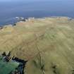
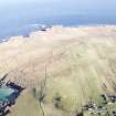
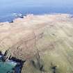
A series of small conjoined turf-walled buildings are drawn across the landward side of a low promontory in the bay of Cunndal, with further groups of turf-walled buildings within this arrangement. The buildings are generally oval or sub-rectangular on plan, with at least one rectangular structure. Further turf buildings, generally singletons, are located to the N around the nearby stream, and S adjacent to the shoreline.
Information from RCAHMS (SMDG) 2 February 2005
This site was listed as a possible early chapel site during the Lewis Coastal chapel sites survey, a research project to identify the chapel sites of Lewis and surrounding islands.
R Barrowman 2005 (RCAHMS MS 2384)
R Barrowman and J Hooper 2006 (RCAHMS MS 2626).
Field Visit (7 July 2010)
This promontory has a string of nine huts constructed along the line of a turf bank which swings in a broad arc from the landward side of a cleft in the low cliffs on the S round to the cliffs on the N. A further four structures can be seen within the area enclosed by the bank on the promontory. The huts on the line of the bank typically measure about 4.4m in length by 3.5m in breadth over a turf bank 0.8m in thickness by up to 0.4m in height. Several seem to have had a stone footing, particularly those larger examples lying on the perimeter.
Visited by RCAHMS (SPH) 7 July 2010
Change Of Classification (7 July 2010)
Field Visit (8 January 2015)
The promontory has curving turf bank on its landward side, with a string of nine small conjoined hut buildings along its line, and four further huts inside the enclosure. The huts are oval or sub-rectangular, average 4.4m by 3.5m defined by banks 0.8m wide and 0.4m high. It has been suggested that the enclosure is prehistoric in date and the hut structures have been interpreted as sheilings of pre-clearance date.
Visited by Scotland's Coastal Heritage at Risk (SCHARP) 8 January 2015
Note
Title: Chapel-sites on the Isle of Lewis: Results of the Lewis Coastal Chapel-sites Survey
Journal: SCOTTISH ARCHAEOLOGICAL INTERNET REPORTS (e-ISSN: 2056-7421)
Author: Barrowman, R C
Publisher: Society of Antiquaries of Scotland, Edinburgh
Date: 2020
MCE (2023): Reviewed as part of the GAPR. Publication was completed in 2020. Open Access publication with SAIR. Publication grant-aided by HES.

