
Pricing Change
New pricing for orders of material from this site will come into place shortly. Charges for supply of digital images, digitisation on demand, prints and licensing will be altered.
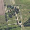
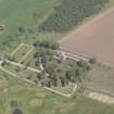
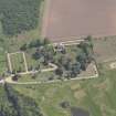
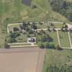
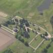
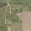
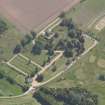
Vicarsford Cemetery, Lodge


Boundary Wall(S) (19th Century), Gate(S) (19th Century), Gate Pier (19th Century), Lodge (19th Century), Railings (19th Century)
Site Name Vicarsford Cemetery, Lodge
Classification Boundary Wall(S) (19th Century), Gate(S) (19th Century), Gate Pier (19th Century), Lodge (19th Century), Railings (19th Century)
Canmore ID 224194
Site Number NO42NW 139
NGR NO 43766 25796
Datum OSGB36 - NGR
Permalink http://canmore.org.uk/site/224194


- Council Fife
- Parish Leuchars
- Former Region Fife
- Former District North East Fife
- Former County Fife

