
Mull, Moy Castle


Tower House (Medieval)
Site Name Mull, Moy Castle
Classification Tower House (Medieval)
Alternative Name(s) Lochbuy; Lochbuie; Loch Buie
Canmore ID 22392
Site Number NM62SW 1
NGR NM 61678 24753
Datum OSGB36 - NGR
Permalink http://canmore.org.uk/site/22392


- Council Argyll And Bute
- Parish Torosay
- Former Region Strathclyde
- Former District Argyll And Bute
- Former County Argyll
NM62SW 1 61678 24753.
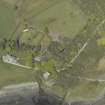
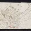
(NM 6168 2474) Moy Castle (NR)
OS 1:10000 map (1976)
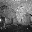
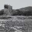
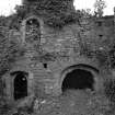
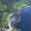
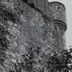
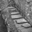
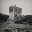
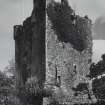
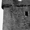
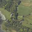
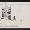
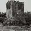
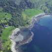
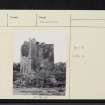
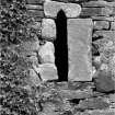
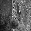
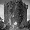
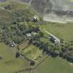
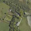
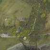
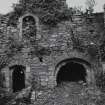
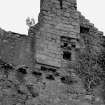
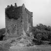
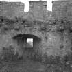
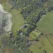
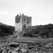
Moy Castle stands on a low rock platform at the head of Loch Buie. The castle is a modest-sized tower-house formerly incorporating a small enclosure or barmkin on the SE side. Much of the surviving fabric of the tower can be ascribed to the first half of the 15th century. Some alterations and additions, confined mainly to the upper works of the tower, were carried out about the turn of the 16th and 17th centuries, and the castle was finally abandoned as a domestic residence about 1752. It is now derelict and roofless, but the walls, although in need of repair, survive virtually complete to the height of the parapet and gables.
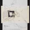
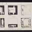
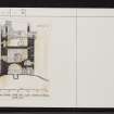
The lack of natural defences on the landward approaches to the site was made good to some extent by the construction of a shallow rock-cut ditch on the NW and by the erection of a wall enclosing an area to the SE of the tower. The rubble core of a section of this barmkin wall can still be seen in places, as shown on plan.
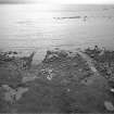
About 8m to the SE of the tower-house there is a rectangular building of comparatively recent date, having a wide entrance facing seaward; this was probably used as a boat-shelter.
RCAHMS 1980, visited 1972
The castle is as described.
Revised at 1:2500.
Visited by OS (DWR) 23 May 1972.
Measured Survey (2 July 2012 - 5 July 2012)
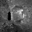
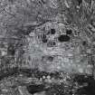
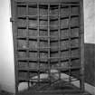
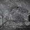
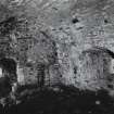
Alder Archaeology was commissioned to undertake a programme of archaeological work on the Scheduled Ancient Monument, Moy Castle, Mull (NGR NM 61678 24753). The work (Alder site code MY01) was carried out during the period 02-05 July 2012 and was the latest in a series of archaeological works undertaken in conjunction with renovations to make the castle water-tight. The location of this phase of the archaeological work was the upper floor level (kitchen chamber or archaeological area 11). The kitchen chamber is an open area below the walkway where clay waterproofing is to be applied over the floor surface and a drain is to be inserted through the outer wall of the E window embrasure. The work entailed photographic recording of the chamber floor deposits, limited excavation of high areas of floor deposits and surface deposits within the window embrasures and the excavation of a short section of pipe trench into the floor of the E window embrasure. The removal of the high areas and excavation of deposits within the embrasures revealed finds of pottery, glass, iron (mainly nails) and animal bone, all considered to be early modern or modern. Of interest was a Dutch customs lead seal of modern date found on surface deposits of the E window embrasure. Parts of the original flooring of square sandstone slabs for the chamber were exposed and some of the internal mortar bonded stonework of the castle E wall was recorded when the pipe trench was excavated. No further archaeological work is required for this phase of the renovation work.
Information from Oasis (alderarc1-138223) 26 March 2013
Note (2016)
Title: ARO38: ‘A little earth above the stone’: Archaeological Investigations 2006–2012 for consolidation work at Moy Castle, Mull, Argyll and Bute
Author: Ray Cachart with an historical account by David R Perry and additional contributions by Tamlin Barton, David Bowler, George Haggarty, Derek Hall, Robin Murdoch, Catherine Smith and Joan A Walsh
Illustrations are by Christopher Fyles, Laura Fyles and Dave Munro
Publisher: GUARD Archaeology, Glasgow
Editor Beverley Ballin Smith
Publication date: 2019
Funder: Historic Environment Scotland
Information from: KMM (2023)

