
Following the launch of trove.scot in February 2025 we are now planning the retiral of some of our webservices. Canmore will be switched off on 24th June 2025. Information about the closure can be found on the HES website: Retiral of HES web services | Historic Environment Scotland
Kirkcaldy, Loughbourgh Road, Viewforth High School


School (20th Century)
Site Name Kirkcaldy, Loughbourgh Road, Viewforth High School
Classification School (20th Century)
Canmore ID 223774
Site Number NT29SE 399
NGR NT 29639 93103
Datum OSGB36 - NGR
Permalink http://canmore.org.uk/site/223774
Ordnance Survey licence number AC0000807262. All rights reserved.
Canmore Disclaimer.
© Bluesky International Limited 2025. Public Sector Viewing Terms
- Correction
- Favourite

DP 191949
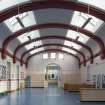
Interior,assembly hall, view from South West.
Records of the Royal Commission on the Ancient and Historical Monuments of Scotland (RCAHMS), Edinbu
10/4/2014
© Crown Copyright: HES

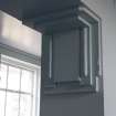
DP 191958
Interior, detail of capital on stairway.
Records of the Royal Commission on the Ancient and Historical Monuments of Scotland (RCAHMS), Edinbu
10/4/2014
© Crown Copyright: HES

DP 191964
Interior, classroom in East block from North West.
Records of the Royal Commission on the Ancient and Historical Monuments of Scotland (RCAHMS), Edinbu
10/4/2014
© Crown Copyright: HES

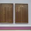
DP 191970
Interior, detail of Girls' Dux boards in main hall.
Records of the Royal Commission on the Ancient and Historical Monuments of Scotland (RCAHMS), Edinbu
10/4/2014
© Crown Copyright: HES

DP 191973
Interior, view down stairs in West flanking corridor.
Records of the Royal Commission on the Ancient and Historical Monuments of Scotland (RCAHMS), Edinbu
10/4/2014
© Crown Copyright: HES

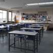
DP 191975
Interior, view of biology classroom in West corridor from North East.
Records of the Royal Commission on the Ancient and Historical Monuments of Scotland (RCAHMS), Edinbu
10/4/2014
© Crown Copyright: HES

DP 191990
View of Technical Blocks from North West.
Records of the Royal Commission on the Ancient and Historical Monuments of Scotland (RCAHMS), Edinbu
10/4/2014
© Crown Copyright: HES

DP 191997
Interior, view of girls' gym from South.
Records of the Royal Commission on the Ancient and Historical Monuments of Scotland (RCAHMS), Edinbu
10/4/2014
© Crown Copyright: HES

DP 191998
Interior, view of girls' changing room.
Records of the Royal Commission on the Ancient and Historical Monuments of Scotland (RCAHMS), Edinbu
10/4/2014
© Crown Copyright: HES

DP 191999
View of girls' gym in central courtyard from South East.
Records of the Royal Commission on the Ancient and Historical Monuments of Scotland (RCAHMS), Edinbu
10/4/2014
© Crown Copyright: HES

DP 192002
View of rear of additional West wing, from East.
Records of the Royal Commission on the Ancient and Historical Monuments of Scotland (RCAHMS), Edinbu
10/4/2014
© Crown Copyright: HES

DP 192005
View of rear of main hall from South east.
Records of the Royal Commission on the Ancient and Historical Monuments of Scotland (RCAHMS), Edinbu
10/4/2014
© Crown Copyright: HES

DP 192020
Annexe, view of old stables from East.
Records of the Royal Commission on the Ancient and Historical Monuments of Scotland (RCAHMS), Edinbu
10/4/2014
© Crown Copyright: HES

DP 192030
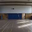
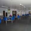
Interior, assembly hall from South east.
Records of the Royal Commission on the Ancient and Historical Monuments of Scotland (RCAHMS), Edinbu
10/4/2014
© Crown Copyright: HES

DP 191952
Interior, view of tuck shop area below assembly hall from East.
Records of the Royal Commission on the Ancient and Historical Monuments of Scotland (RCAHMS), Edinbu
10/4/2014
© Crown Copyright: HES

DP 191976
Annexe, formerly Eastbank House. View of Front elevation from South.
Records of the Royal Commission on the Ancient and Historical Monuments of Scotland (RCAHMS), Edinbu
10/4/2014
© Crown Copyright: HES

DP 191980
View along West wing from North West.
Records of the Royal Commission on the Ancient and Historical Monuments of Scotland (RCAHMS), Edinbu
10/4/2014
© Crown Copyright: HES

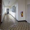
DP 192008
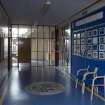
Interior, view of East entrance lobby.
Records of the Royal Commission on the Ancient and Historical Monuments of Scotland (RCAHMS), Edinbu
10/4/2014
© Crown Copyright: HES

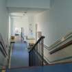
DP 192013
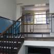
Interior, view up staircase on east flanking corridor.
Records of the Royal Commission on the Ancient and Historical Monuments of Scotland (RCAHMS), Edinbu
10/4/2014
© Crown Copyright: HES

DP 192021
View of girls' entrance.
Records of the Royal Commission on the Ancient and Historical Monuments of Scotland (RCAHMS), Edinbu
10/4/2014
© Crown Copyright: HES

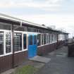
DP 192022
View of dining block from North.
Records of the Royal Commission on the Ancient and Historical Monuments of Scotland (RCAHMS), Edinbu
10/4/2014
© Crown Copyright: HES

DP 192024
View of central block, front elevation, from North.
Records of the Royal Commission on the Ancient and Historical Monuments of Scotland (RCAHMS), Edinbu
10/4/2014
© Crown Copyright: HES

DP 192029
Detail of cupola and weather vane.
Records of the Royal Commission on the Ancient and Historical Monuments of Scotland (RCAHMS), Edinbu
10/4/2014
© Crown Copyright: HES

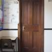
DP 191959
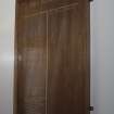
Interior, sample door on upper floor of East block.
Records of the Royal Commission on the Ancient and Historical Monuments of Scotland (RCAHMS), Edinbu
10/4/2014
© Crown Copyright: HES

DP 191966
Interior, view of main hall from East.
Records of the Royal Commission on the Ancient and Historical Monuments of Scotland (RCAHMS), Edinbu
10/4/2014
© Crown Copyright: HES

DP 191979
Annexe, formerly Eastbank House. View of West elevation and entrance from North.
Records of the Royal Commission on the Ancient and Historical Monuments of Scotland (RCAHMS), Edinbu
10/4/2014
© Crown Copyright: HES

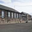
DP 191993
View of former Janitor's House from West.
Records of the Royal Commission on the Ancient and Historical Monuments of Scotland (RCAHMS), Edinbu
10/4/2014
© Crown Copyright: HES

DP 192003
View of rear of additional West wing, from South East.
Records of the Royal Commission on the Ancient and Historical Monuments of Scotland (RCAHMS), Edinbu
10/4/2014
© Crown Copyright: HES

DP 192012
Interior, detail of tiles in main hall. Viewforth High School, Kirkcaldy
Records of the Royal Commission on the Ancient and Historical Monuments of Scotland (RCAHMS), Edinbu
10/4/2014
© Crown Copyright: HES

DP 192014
Interior, detail of school crest above stage.
Records of the Royal Commission on the Ancient and Historical Monuments of Scotland (RCAHMS), Edinbu
10/4/2014
© Crown Copyright: HES

DP 192015
Interior, view from main hall towards West flanking corridor.
Records of the Royal Commission on the Ancient and Historical Monuments of Scotland (RCAHMS), Edinbu
10/4/2014
© Crown Copyright: HES

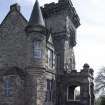
DP 192017
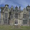
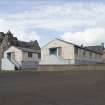
View of front elevation from North West.
Records of the Royal Commission on the Ancient and Historical Monuments of Scotland (RCAHMS), Edinbu
10/4/2014
© Crown Copyright: HES

DP 192025
Detail of carving.
Records of the Royal Commission on the Ancient and Historical Monuments of Scotland (RCAHMS), Edinbu
10/4/2014
© Crown Copyright: HES

DP 192028
Detail of carving.
Records of the Royal Commission on the Ancient and Historical Monuments of Scotland (RCAHMS), Edinbu
10/4/2014
© Crown Copyright: HES

DP 191955
Interior, view of art room from South.
Records of the Royal Commission on the Ancient and Historical Monuments of Scotland (RCAHMS), Edinbu
10/4/2014
© Crown Copyright: HES

DP 191965
Interior, detail of School logo in linolleum.
Records of the Royal Commission on the Ancient and Historical Monuments of Scotland (RCAHMS), Edinbu
10/4/2014
© Crown Copyright: HES

DP 191971
Interior, detail of War Memorial.
Records of the Royal Commission on the Ancient and Historical Monuments of Scotland (RCAHMS), Edinbu
10/4/2014
© Crown Copyright: HES

DP 191978
Annexe, formerly Eastbank House. View of West elevation and entrance.
Records of the Royal Commission on the Ancient and Historical Monuments of Scotland (RCAHMS), Edinbu
10/4/2014
© Crown Copyright: HES

DP 191984
View of prefab block from South East.
Records of the Royal Commission on the Ancient and Historical Monuments of Scotland (RCAHMS), Edinbu
10/4/2014
© Crown Copyright: HES

DP 191991
Detail of Technical Block.
Records of the Royal Commission on the Ancient and Historical Monuments of Scotland (RCAHMS), Edinbu
10/4/2014
© Crown Copyright: HES

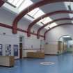
DP 191995
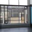
View of Entrance to modern block and Assembly Hall from East.
Records of the Royal Commission on the Ancient and Historical Monuments of Scotland (RCAHMS), Edinbu
10/4/2014
© Crown Copyright: HES

DP 192018
View of central block of front elevation from North West.
Records of the Royal Commission on the Ancient and Historical Monuments of Scotland (RCAHMS), Edinbu
10/4/2014
© Crown Copyright: HES

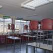
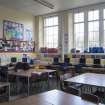
DP 191963
Interior, classroom in East block from South.
Records of the Royal Commission on the Ancient and Historical Monuments of Scotland (RCAHMS), Edinbu
10/4/2014
© Crown Copyright: HES

DP 191982
View of additional West wing and modern block - music, art and P.E, from North West
Records of the Royal Commission on the Ancient and Historical Monuments of Scotland (RCAHMS), Edinbu
10/4/2014
© Crown Copyright: HES

DP 191986
View along new block - P.E - from West though playgound to Rectors' landing.
Records of the Royal Commission on the Ancient and Historical Monuments of Scotland (RCAHMS), Edinbu
10/4/2014
© Crown Copyright: HES

DP 191992
View of Assembly Hall from South West.
Records of the Royal Commission on the Ancient and Historical Monuments of Scotland (RCAHMS), Edinbu
10/4/2014
© Crown Copyright: HES

DP 192010
Interior, detail of capital in main hall.
Records of the Royal Commission on the Ancient and Historical Monuments of Scotland (RCAHMS), Edinbu
10/4/2014
© Crown Copyright: HES

DP 192011
Interior, detail of tiles in main hall. Viewforth High School, Kirkaldy
Records of the Royal Commission on the Ancient and Historical Monuments of Scotland (RCAHMS), Edinbu
10/4/2014
© Crown Copyright: HES

DP 192019
Detail of boys' entrance.
Records of the Royal Commission on the Ancient and Historical Monuments of Scotland (RCAHMS), Edinbu
10/4/2014
© Crown Copyright: HES

DP 192027
Detail of carving.
Records of the Royal Commission on the Ancient and Historical Monuments of Scotland (RCAHMS), Edinbu
10/4/2014
© Crown Copyright: HES

DP 191953
Interior, view of art room from East.
Records of the Royal Commission on the Ancient and Historical Monuments of Scotland (RCAHMS), Edinbu
10/4/2014
© Crown Copyright: HES

DP 191954
Interior, view from art department to music room, from East.
Records of the Royal Commission on the Ancient and Historical Monuments of Scotland (RCAHMS), Edinbu
10/4/2014
© Crown Copyright: HES

DP 191956
Interior, view of stairs and landing leading to art department and stage, from South.
Records of the Royal Commission on the Ancient and Historical Monuments of Scotland (RCAHMS), Edinbu
10/4/2014
© Crown Copyright: HES

DP 191960
Interior, detail of ironwork on East stairway.
Records of the Royal Commission on the Ancient and Historical Monuments of Scotland (RCAHMS), Edinbu
10/4/2014
© Crown Copyright: HES

DP 191969
Interior, detail of Boys' Dux boards in main hall.
Records of the Royal Commission on the Ancient and Historical Monuments of Scotland (RCAHMS), Edinbu
10/4/2014
© Crown Copyright: HES

DP 191985
View of West wing from South West.
Records of the Royal Commission on the Ancient and Historical Monuments of Scotland (RCAHMS), Edinbu
10/4/2014
© Crown Copyright: HES

DP 192004
View of rear of additional east wing, from South.
Records of the Royal Commission on the Ancient and Historical Monuments of Scotland (RCAHMS), Edinbu
10/4/2014
© Crown Copyright: HES

DP 192016
View of front elevation from North East.
Records of the Royal Commission on the Ancient and Historical Monuments of Scotland (RCAHMS), Edinbu
10/4/2014
© Crown Copyright: HES

DP 191962
Interior, detail of sign.
Records of the Royal Commission on the Ancient and Historical Monuments of Scotland (RCAHMS), Edinbu
10/4/2014
© Crown Copyright: HES

DP 191967
Interior, view of main hall from North West.
Records of the Royal Commission on the Ancient and Historical Monuments of Scotland (RCAHMS), Edinbu
10/4/2014
© Crown Copyright: HES

DP 191972
Interior, view down West flanking corridor, from North.
Records of the Royal Commission on the Ancient and Historical Monuments of Scotland (RCAHMS), Edinbu
10/4/2014
© Crown Copyright: HES

DP 191989
View along modern block and assembly hall from South West.
Records of the Royal Commission on the Ancient and Historical Monuments of Scotland (RCAHMS), Edinbu
10/4/2014
© Crown Copyright: HES

DP 192006
Interior, view from East flanking corridor of entrance and reception.
Records of the Royal Commission on the Ancient and Historical Monuments of Scotland (RCAHMS), Edinbu
10/4/2014
© Crown Copyright: HES

DP 192007
Interior, view of reception from East towards main hall.
Records of the Royal Commission on the Ancient and Historical Monuments of Scotland (RCAHMS), Edinbu
10/4/2014
© Crown Copyright: HES

DP 192023
View to rear of technical blocks showing two storeys from East.
Records of the Royal Commission on the Ancient and Historical Monuments of Scotland (RCAHMS), Edinbu
10/4/2014
© Crown Copyright: HES

DP 192026
Detail of cupola and weather vane.
Records of the Royal Commission on the Ancient and Historical Monuments of Scotland (RCAHMS), Edinbu
10/4/2014
© Crown Copyright: HES

DP 191950
Interior, view of Rector's landing from North.
Records of the Royal Commission on the Ancient and Historical Monuments of Scotland (RCAHMS), Edinbu
10/4/2014
© Crown Copyright: HES

DP 191951
Interior, detail of Dux board on Rector's Landing.
Records of the Royal Commission on the Ancient and Historical Monuments of Scotland (RCAHMS), Edinbu
10/4/2014
© Crown Copyright: HES

DP 191957
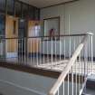
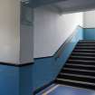
Interior, detail of stairway in east flanking corridor of old block. From South West.
Records of the Royal Commission on the Ancient and Historical Monuments of Scotland (RCAHMS), Edinbu
10/4/2014
© Crown Copyright: HES

DP 191961
Interior, view showing ironwork on East stairway.
Records of the Royal Commission on the Ancient and Historical Monuments of Scotland (RCAHMS), Edinbu
10/4/2014
© Crown Copyright: HES

DP 191968
Interior, view of main hall from North East.
Records of the Royal Commission on the Ancient and Historical Monuments of Scotland (RCAHMS), Edinbu
10/4/2014
© Crown Copyright: HES

DP 191974
Interior, view of biology classroom in West corridor from South West.
Records of the Royal Commission on the Ancient and Historical Monuments of Scotland (RCAHMS), Edinbu
10/4/2014
© Crown Copyright: HES

DP 191977
View of prefabs from West.
Records of the Royal Commission on the Ancient and Historical Monuments of Scotland (RCAHMS), Edinbu
10/4/2014
© Crown Copyright: HES

DP 191981
View of prefab block from South East with annexe in background.
Records of the Royal Commission on the Ancient and Historical Monuments of Scotland (RCAHMS), Edinbu
10/4/2014
© Crown Copyright: HES

DP 191983
View of newer block and portacabin used as classroom from North.
Records of the Royal Commission on the Ancient and Historical Monuments of Scotland (RCAHMS), Edinbu
10/4/2014
© Crown Copyright: HES

DP 191987
View of prefabs used as classrooms from North East.
Records of the Royal Commission on the Ancient and Historical Monuments of Scotland (RCAHMS), Edinbu
10/4/2014
© Crown Copyright: HES

DP 191988
Rear of biology building from South East.
Records of the Royal Commission on the Ancient and Historical Monuments of Scotland (RCAHMS), Edinbu
10/4/2014
© Crown Copyright: HES

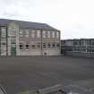
DP 191994
Elevated view of Technical Blocks, from North east.
Records of the Royal Commission on the Ancient and Historical Monuments of Scotland (RCAHMS), Edinbu
10/4/2014
© Crown Copyright: HES

DP 191996
Interior, view of girls' gym from North.
Records of the Royal Commission on the Ancient and Historical Monuments of Scotland (RCAHMS), Edinbu
10/4/2014
© Crown Copyright: HES

DP 192000
View of girls' gym in central courtyard from South West.
Records of the Royal Commission on the Ancient and Historical Monuments of Scotland (RCAHMS), Edinbu
10/4/2014
© Crown Copyright: HES

DP 192001
View of gym and assembly hall from North West.
Records of the Royal Commission on the Ancient and Historical Monuments of Scotland (RCAHMS), Edinbu
10/4/2014
© Crown Copyright: HES

DP 192009
Interior, detail of capital in main hall.
Records of the Royal Commission on the Ancient and Historical Monuments of Scotland (RCAHMS), Edinbu
10/4/2014
© Crown Copyright: HES


- Council Fife
- Parish Kirkcaldy And Dysart
- Former Region Fife
- Former District Kirkcaldy
- Former County Fife
Photographic Survey
A survey of the site has been requisitioned prior to closure

