
Pricing Change
New pricing for orders of material from this site will come into place shortly. Charges for supply of digital images, digitisation on demand, prints and licensing will be altered.
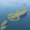
Garvellachs, Dun Chonnail


Building (Medieval) - (Post Medieval), Enclosure (Medieval) - (Post Medieval)
Site Name Garvellachs, Dun Chonnail
Classification Building (Medieval) - (Post Medieval), Enclosure (Medieval) - (Post Medieval)
Alternative Name(s) Dun Chonnull
Canmore ID 22377
Site Number NM61SE 6
NGR NM 68032 12669
Datum OSGB36 - NGR
Permalink http://canmore.org.uk/site/22377


- Council Argyll And Bute
- Parish Jura
- Former Region Strathclyde
- Former District Argyll And Bute
- Former County Argyll
Field Visit (July 1974)
To the SW there is an enclosure (L) flanked on one side by a building and on the other by two small reed-grown depressions which may have been used as water-catchment pools.
RCAHMS 1984, visited July 1974
Note
(NM 6802 1266) One unroofed buildling and two enclosures are depicted on the 1st edition of the OS 6-inch map (Argyllshire 1881, sheet cxxviii), but they are not shown on the current edition of the OS 1:10000 map (1973).
Information from RCAHMS (SAH) 24 September 1998

