
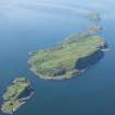
Garvellachs, Garbh Eileach


Corn Drying Kiln(S) (18th Century) - (19th Century), Cruck Framed Building (Post Medieval), Farmstead (18th Century) - (19th Century)
Site Name Garvellachs, Garbh Eileach
Classification Corn Drying Kiln(S) (18th Century) - (19th Century), Cruck Framed Building (Post Medieval), Farmstead (18th Century) - (19th Century)
Canmore ID 22376
Site Number NM61SE 5
NGR NM 67246 12209
NGR Description NM 67246 12209 and NM 67162 12189
Datum OSGB36 - NGR
Permalink http://canmore.org.uk/site/22376


- Council Argyll And Bute
- Parish Jura
- Former Region Strathclyde
- Former District Argyll And Bute
- Former County Argyll
NM61SE 5 6724 1220
(NM 672 122) Cruck-slots noted in house and corn-drying kiln.
G Stell 1981
One unroofed long building with an outshot and one enclosure are depicted on the 1st edition of the OS 6-inch map (Argyllshire 1881, sheet cxxviii). One unroofed building, one incomplete enclosure and a short length of wall are shown on the current edition of the OS 1:10000 map (1973).
Information from RCAHMS (SAH) 24 September 1998
Field Visit (May 1981)
(NM 672 122) The roofless ruin of a house with attached barn or byre stands in a prominent position on a S-sloping hillside about 650m NE of the dun, Rubha Mhor. The barn or byre, which measures 11.4m from NE to SW by 5.5m transversely over 0.8m walls and has an entrance-doorway in the NW wall, is constructed of clay-mortared rubble and appears to be of earlier date than the dwelling, whose rubble masonry is bonded in clay mortar pointed with lime. The dwelling measures 11.7m by 5.5m over all and originally had opposed entrance-doorways; that in the SE wall was subsequently altered to a window, perhaps at the same time as an original window in that wall was blocked. It may have had a central hearth, but a fireplace and chimney were subsequently added to the SW gable-wall. Its roof was originally carried on three cruck-couples, as shown by recesses in the side-walls, while a single cruck-recess survives in the NW wall of the barn. Several stone thatch-pegs project from the NW wall.
A corn-drying kiln situated on a knoll some 70m W of the dwelling was excavated in 1972, when some collapsed parts of the bowl were repaired (Mercer 1972). It closely resembles that on Eileachan Naoimh, measuring 7.6m by about 5m over all, but no masonry survives above the level of the platform incorporating the kiln-bowl. The walls of the enclosed N part have an average thickness of about 0.8m, and it was entered by opposed doorways in the side-walls. The masonry is of local rubble bonded in clay-mortar, and the N gable-wall incorporates a single cruck-recess, presumably designed to support a hipped roof. A series of steps is formed against the NE wall to allow access to the kiln-bowl, which measures 1.4m in height and 2.1m in diameter at the top, and the partially lintelled flue extends obliquely across the building towards the NE door, presumably to increase the draught. To the sw of the kiln there is an enclosure, presumably a stack-yard, measuring 15m by 8m within drystone walls 1m thick.
The island of Garbh Eileach, formerly part of the MacLean of Duart estate, was granted by the 9th Earl of Argyll in wadset to John MacLachlan of Kilbride in 1666, and for most of the 18th century the island was held by MacLachlan wadsetters or tacksmen, although Dougal MacDougall of Gallanach secured the tack from 1749 to 1757 (Campbell 1934; Scot Stud 1977; Cregeen, Estate Instructions). A survey by George Langlands in 1788 classified as arable only about 3 ha (7 acres) of the island's total area of about 118 ha (290 acres), a further 12 ha (28 acres) being described as 'mixed arable and pasture' and most of the remainder as pasture. (Mercer 1974) A lease of 1817 allowed for the grazing of up to sixty cattle and 240 sheep on the islands of the group.(Mercer 1974) Garbh Eileach had a population of thirty-two adults in the late 17th century, and there were eighteen persons of catechisable age in 1724, but by 1861 only four houses were occupied, and it is likely that thereafter only the shepherd's cottage near the landing-place and burial-ground remained in use (Hist MSS Comm, 6th Report appendix; Kintyre Presbytery Minutes, 1724; Mercer 1974). The buildings described above were probably erected in the late 18th or 19th century.
RCAHMS 1984, visited May 1981

