
Pricing Change
New pricing for orders of material from this site will come into place shortly. Charges for supply of digital images, digitisation on demand, prints and licensing will be altered.
Garvellachs, Eileach An Naoimh


Building(S) (Post Medieval), Burial Ground (Period Unknown), Long Cist(S) (Period Unknown)
Site Name Garvellachs, Eileach An Naoimh
Classification Building(S) (Post Medieval), Burial Ground (Period Unknown), Long Cist(S) (Period Unknown)
Alternative Name(s) Port Chaluim Chille; Geodha Bhride; Sw Burial Ground
Canmore ID 22366
Site Number NM60NW 6
NGR NM 63925 09537
Datum OSGB36 - NGR
Permalink http://canmore.org.uk/site/22366


- Council Argyll And Bute
- Parish Jura
- Former Region Strathclyde
- Former District Argyll And Bute
- Former County Argyll
NM60NW 6 6390 0947.
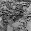
An ancient graveyard in the valley which extends from an offset of the Port Chaluim Chille to the head of Geodha Bhride, bounded by a low drystone wall, much ruined and overgrown, 3 1/2 - 4 1/2' wide and 2-3' high, enclosing an oblong 103' by 35', with an entrance 2' 8" wide in the middle of the NE side. There are two much ruined drystone buildings in each extremity of the enclosure, that at the NE being 24' by 12', the other 14' by 8' 6", both within walls c. 3' thick. There is a long cist near the SE corner of the SW building, and several others were excavated at time of visit.
T Bryce and G A F Knight 1930
As described. Situated at NM 6390 0947.
Visited by OS (AC) 8 April 1970
Field Visit (May 1981)
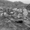
The South-West Burial-Ground. This subrectangular enclosure is situated about 200m SW of the inner enclosure, on a platform of level ground between the SW limb of the boat-landing and another steep-sided inlet, Geodha Bhride, to the SW. It measures 30m from NE to SW by 9m transversely within a drystone wall averaging about 1m in thickness, which incorporates on the SE two massive slabs, set on edge and up to 1.6m in height. The outlines of two round-angled buildings, with drystone walls 1m in thickness and up to 0.8m in height survive near the end-walls of the enclosure.
Each had an entrance in its SE wall, and that to the NE was the larger, measuring 8m by 5.7m over all. Excavations by the Glasgow Archaeological Society expedition in 1927 revealed four roughly-constructed slab-lined graves, all much disturbed, lying between the two buildings and in one case partially underlying the SW wall of the larger building. (Bryce and Knight 1933) The date of the burials is uncertain, but the buildings probably belong to the period of post-medieval agrarian settlement.
Visited May 1981
RCAHMS 1984

