Following the launch of trove.scot in February 2025 we are now planning the retiral of some of our webservices. Canmore will be switched off on 24th June 2025. Information about the closure can be found on the HES website: Retiral of HES web services | Historic Environment Scotland
Branault, Cladh Chatain
Church (Period Unassigned), Standing Stone(S) (Prehistoric), Well (Period Unassigned)
Site Name Branault, Cladh Chatain
Classification Church (Period Unassigned), Standing Stone(S) (Prehistoric), Well (Period Unassigned)
Alternative Name(s) Branault, Cladh Chatain, Standing Stone
Canmore ID 22343
Site Number NM56NW 2
NGR NM 5269 6949
Datum OSGB36 - NGR
Permalink http://canmore.org.uk/site/22343
- Council Highland
- Parish Ardnamurchan
- Former Region Highland
- Former District Lochaber
- Former County Argyll
NM56NW 2 5269 6949
(Name: NM 5272 6954) Cladh Chatian (NR)
(NM 5269 6949) Stone (NAT)
OS 6" map, Argyllshire, [undated].
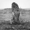
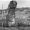
The ONB applies the name 'Cladh Chatain' to the pre-historic standing stone, 6ft high and 2ft broad, called 'Clach Chatain' by Donaldson. Simpson states that Cladh Chatain is the site of a church founded by St Catan (d. 710), and Donaldson mentions a well situated by the side of the Kilmory road, possibly holy, as it is near Clach Chatain, and also that another standing stone also stood here, quoting an old local inhabitant.
Name Book 1872; M E M Donaldson 1923; W D Simpson 1935.
This standing stone is in a hollow between two low eminences; about 1.0m to the NW is another earthfast stone, 0.5m high, possibly the stump of the other stone mentioned by Donaldson. The name 'Cladh Chatain' is not now applied to the stone, but is believed locally to apply to the site of a church, whose position, and that of the alleged holy well, is not known.
Surveyed at 1:2500.
Visited by OS (N K B), 8 June 1970.
(NM 5268 6950) Standing Stone (NR)
OS 1:10,000 map, (1974).
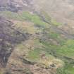
Standing Stones, Cladh Chatian, Branault: There are two standing stones of basalt in a hollow between a pair of rock ridges 460m NW of Branault. One stone measures 2.2m in height and 1m by 0.6m at the base; the top is rounded. The other stone, 0.9m to the NNW, is now only a stump measuring 0.5m in height and 0.5m by 0.4m at the base.
(RCAHMS make no mention of a church / chapel site here).
RCAHMS 1980, visited 1974.


