
Mull, Aros Castle


Castle (Medieval), Hall House (Medieval)
Site Name Mull, Aros Castle
Classification Castle (Medieval), Hall House (Medieval)
Canmore ID 22272
Site Number NM54SE 1
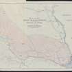
NGR NM 56287 44989
Datum OSGB36 - NGR
Permalink http://canmore.org.uk/site/22272


- Council Argyll And Bute
- Parish Kilninian And Kilmore
- Former Region Strathclyde
- Former District Argyll And Bute
- Former County Argyll
NM54SE 1 56287 44989
(NM 5629 4498) Aros Castle (NR)
(remains of)
OS 1:10,000 map, (1976).
Not to be confused with White House of Aros (NM 5645 4554), for which see NM54NE 8.00.
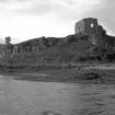
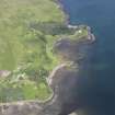
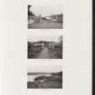
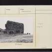
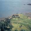
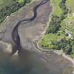
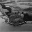
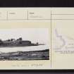
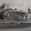
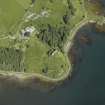
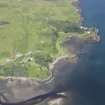
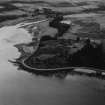
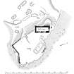
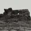
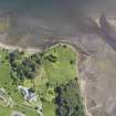
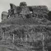
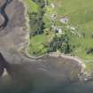
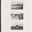
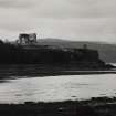
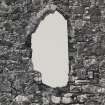
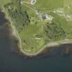
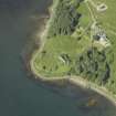
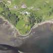
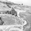
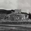
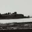
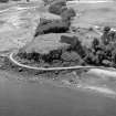
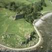
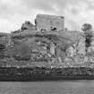
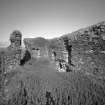
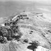
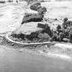
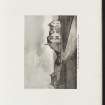
The ruins of Aros Castle, lying about 2 km NW of Salen, constitute a prominent landmark on the W coast of the Sound of Mull. They occupy a strategically important position on a flat-topped promontory.
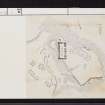
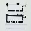
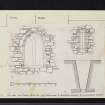
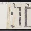
The principal remains are those of a hall-house and bailey defended on the landward side by a ditch and bank. The hall-house occupies the NW portion of the summit, the remaining area of which was enclosed by a stone curtain-wall to form an approximately square bailey some 0.19 ha (0.47 acres) in extent. The principal approach appears to have been by way of a causeway which crossed the N section of the ditch, thence passing beneath the SW corner of the hall-house to enter a gateway in the W wall of the bailey. Another track, probably of comparatively recent origin, leads westwards from the gateway, passing across the bottom of the ditch and through the outer bank.
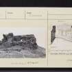
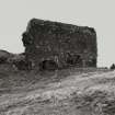
The hall-house is more or less oblong on plan (q.v.), measuring about 25.3m from N to S by 12.5 transversely over walls varying from 1.7m to 3.0m in thickness. The structure appears to have comprised two main storeys and a part attic; the walls now stand to a maximum height of about 10m. Architectural details suggest that it was built in the 13th century.
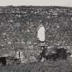
The curtain-wall that formerly enclosed the bailey survives only along parts of the W and S sides. It varies in width from 1.1m to 1.7m and now rises to a maximum external height of 1.2m. Elsewhere the wall is represented only by a turf-grown mound of debris, while along part of the E side, where it could be quarried easily, it has disappeared completely. The interior of the bailey is much overgrown, but the stone footings of a rectangular building (A on plan, q.v.) may be seen close to the E wall. Traces of another building (B) lie immediately to the NW. The remains of at least five other buildings (C - G) can be seen SW of the hall-house. Some of these may post-date the occupation of the castle.
The castle was probably built by one of the MacDougall lords of Lorn in the 13th century. It first comes on record (as 'Dounarwyse') in the later 14th century when it was in the possession of the Lords of the Isles. It appears to have been garrisoned by Argyll's troops in 1690, though it was described two years previously as 'ruinous, old, useless and never of any Strength'. Throughout the 18th century the lands of Aros were farmed by a succession of Campbell tacksmen, but there is no record of the castle having been inhabited at this period.
RCAHMS 1980, visited 1973.
The remains at this site were in a similar condition to that described above when seen in 1972.
Revised at 1:2500.
Visited by OS (J P) 2 May 1972.
Fabric Recording (2015)
NM 56280 44980 (Canmore ID: 22272) The Scottish Medieval Castles and Chapels C14 Project (SMCCCP) is a nationwide buildings archaeology project investigating the archaeological potential of building materials surviving within upstanding medieval structures. The SMCCCP combines the survey and analysis of medieval buildings and environments, with the analysis and radiocarbon dating of surviving building materials. The project seeks to constrain building chronologies, and investigate the technical conversion and palaeoenvironmental potential of source materials. The upstanding masonry of Aros Castle was analysed and a number of building and environmental materials recorded and sampled in 2015. These materials are undergoing further analysis and, where appropriate, will be AMS radiocarbon dated.
Archive: National Record of the Historic Environment (NRHE) intended
Funder: Historic Scotland
Mark Thacker – University of Edinburgh
(Source: DES, Volume 16)

