
Following the launch of trove.scot in February 2025 we are now planning the retiral of some of our webservices. Canmore will be switched off on 24th June 2025. Information about the closure can be found on the HES website: Retiral of HES web services | Historic Environment Scotland
Erskine, Erskine Ferry


Ferry Crossing (18th Century), Ferry (Period Unassigned)
Site Name Erskine, Erskine Ferry
Classification Ferry Crossing (18th Century), Ferry (Period Unassigned)
Alternative Name(s) River Clyde; Clyde Ferry
Canmore ID 222560
Site Number NS47SE 205
NGR NS 4636 7223
NGR Description NS 4626 7209 to NS 4646 7237
Datum OSGB36 - NGR
Permalink http://canmore.org.uk/site/222560


- Council Renfrewshire
- Parish Erskine
- Former Region Strathclyde
- Former District Renfrew
- Former County Renfrewshire
NS47SE 205 4636 7223 (NS 4626 7209 to NS 4646 7237)
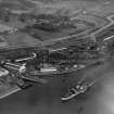
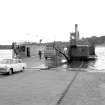
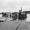
This ferry formerly crossed the River Clyde between the parishes of Erskine (Renfrewshire) to the S and Old Kilpatrick (Clydebank) to the N. Latterly a chain ferry, it was superseded by the Erskine Bridge (NS47SE 70) in 1971.
Information from RCAHMS (RC), 8 October 2002.

