
Following the launch of trove.scot in February 2025 we are now planning the retiral of some of our webservices. Canmore will be switched off on 24th June 2025. Information about the closure can be found on the HES website: Retiral of HES web services | Historic Environment Scotland
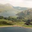
Loch Ba, Mull


Crannog (Period Unassigned)
Site Name Loch Ba, Mull
Classification Crannog (Period Unassigned)
Canmore ID 22235
Site Number NM53NE 1
NGR NM 5548 3897
Datum OSGB36 - NGR
Permalink http://canmore.org.uk/site/22235


- Council Argyll And Bute
- Parish Torosay
- Former Region Strathclyde
- Former District Argyll And Bute
- Former County Argyll
NM53NE 1 5548 3897.
(NM 5548 3897) Crannog (NR)
OS 1:10,000 map, (1976)
This crannog is represented by a half-submerged circular pile of stones about 20m in diameter in water some 0.3m deep. No timber or any stone setting is visible, but the stones rise steeply from the bed of the loch as if revetted.
Surveyed at 1:2500.
Argyll County Council 1914; Visited by OS (D W R) 4 May 1972.
Crannog, Loch Ba: The small unnamed island situated at the NW end of Loch Ba, some 450m SE of Gruline House, appears to be composed entirely of loose boulders and is probably of artificial origin. At the date of visit, when the level of the loch was unusually low, it measured about 12m across and rose to a height of 1.2m; no evidence of a timber substructure or causeway was observed. Dean Munro, writing in 1549, described the islands of Loch Ba and Loch Sguabain as inhabited strongholds. The island at the NW end of the loch is shown, but not as an inhabited site, on Pont's map of last quarter of the 16th century.
RCAHMS 1980, visited 1973.
The site's underwater features are more extensive than those previously noted. The crannog is roughly oval in plan, measuring 25m by 30m at its base and only 7m by 7m at water level. It is built on what appears to be the end of gravel outwash and rises 3m above the surrounding loch bed. The upper surface area was quite large, roughly 21 m by 23m or 379 sq m, most of which was 0.7m below the water level when the site was surveyed. Water 5m in depth surrounds the site. Several circuits were made of the island and no evidence of walling, cut stone, timbers, or a causeway was found.
Sponsors: University of Edinburgh Department of Archaeology; Holley & Assoc.
M W Holley 1994e.

