|
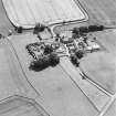
Photographs and Off-line Digital Images |
D 74866 |
RCAHMS Aerial Photography |
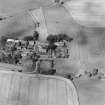
Oblique aerial view centred on the church and burial ground with manse, schoolhouse, farmsteading and road bridge adjacent, taken from the SSE. |
14/8/2000 |
Item Level |
|
|
Photographs and Off-line Digital Images |
D 74867 |
RCAHMS Aerial Photography |
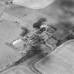
Oblique aerial view centred on the church and burial ground with manse, schoolhouse, farmsteading and road bridge adjacent, taken from the S. |
14/8/2000 |
Item Level |
|
|
Photographs and Off-line Digital Images |
D 74868 |
RCAHMS Aerial Photography |
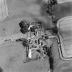
Oblique aerial view centred on the church and burial ground with manse, schoolhouse, farmsteading and road bridge adjacent, taken from the WSW. |
14/8/2000 |
Item Level |
|
|
Photographs and Off-line Digital Images |
D 74869 |
RCAHMS Aerial Photography |
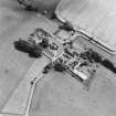
Oblique aerial view centred on the church and burial ground with manse, schoolhouse, farmsteading and road bridge adjacent, taken from the WNW. |
14/8/2000 |
Item Level |
|
|
Photographs and Off-line Digital Images |
D 74870 |
RCAHMS Aerial Photography |
Oblique aerial view centred on the church and burial ground with manse, schoolhouse, farmsteading and road bridge adjacent, taken from the N. |
14/8/2000 |
Item Level |
|
|
Photographs and Off-line Digital Images |
DP 124347 |
Buildings at Risk Register |
Old Schoolhouse Rear elevation |
19/6/2009 |
Item Level |
|
|
Photographs and Off-line Digital Images |
DP 124348 |
Buildings at Risk Register |
Old Schoolhouse Rear elevation |
19/6/2009 |
Item Level |
|
|
Photographs and Off-line Digital Images |
DP 124349 |
Buildings at Risk Register |
Old Schoolhouse Rear elevation (detail) |
19/6/2009 |
Item Level |
|
|
Photographs and Off-line Digital Images |
DP 124350 |
Buildings at Risk Register |
Old Schoolhouse Front elevation |
19/6/2009 |
Item Level |
|
|
Photographs and Off-line Digital Images |
DP 149936 |
Buildings at Risk Register |
Side/ Rear Elevations |
29/10/2012 |
Item Level |
|
|
Photographs and Off-line Digital Images |
DP 149937 |
Buildings at Risk Register |
Front Elevation |
29/10/2012 |
Item Level |
|
|
Photographs and Off-line Digital Images |
DP 149938 |
Buildings at Risk Register |
Front Elevation |
29/10/2012 |
Item Level |
|
|
Photographs and Off-line Digital Images |
DP 149939 |
Buildings at Risk Register |
Side/ Front Elevation |
29/10/2012 |
Item Level |
|
|
Photographs and Off-line Digital Images |
DP 240197 |
Records of the Royal Commission on the Ancient and Historical Monuments of Scotland (RCAHMS), Edinbu |
From North West |
21/6/2016 |
Item Level |
|
 |
On-line Digital Images |
SC 1688367 |
RCAHMS Aerial Photography |
Oblique aerial view centred on the church and burial ground with manse, schoolhouse, farmsteading and road bridge adjacent, taken from the SSE. |
14/8/2000 |
Item Level |
|
 |
On-line Digital Images |
SC 1688368 |
RCAHMS Aerial Photography |
Oblique aerial view centred on the church and burial ground with manse, schoolhouse, farmsteading and road bridge adjacent, taken from the S. |
14/8/2000 |
Item Level |
|
 |
On-line Digital Images |
SC 1688369 |
RCAHMS Aerial Photography |
Oblique aerial view centred on the church and burial ground with manse, schoolhouse, farmsteading and road bridge adjacent, taken from the WSW. |
14/8/2000 |
Item Level |
|
 |
On-line Digital Images |
SC 1688370 |
RCAHMS Aerial Photography |
Oblique aerial view centred on the church and burial ground with manse, schoolhouse, farmsteading and road bridge adjacent, taken from the WNW. |
14/8/2000 |
Item Level |
|
 |
On-line Digital Images |
SC 1688371 |
RCAHMS Aerial Photography |
Oblique aerial view centred on the church and burial ground with manse, schoolhouse, farmsteading and road bridge adjacent, taken from the N. |
14/8/2000 |
Item Level |
|


