Following the launch of trove.scot in February 2025 we are now planning the retiral of some of our webservices. Canmore will be switched off on 24th June 2025. Information about the closure can be found on the HES website: Retiral of HES web services | Historic Environment Scotland
Glac Mhor, Dervaig, Mull
Standing Stone(S) (Prehistoric)
Site Name Glac Mhor, Dervaig, Mull
Classification Standing Stone(S) (Prehistoric)
Alternative Name(s) Kilmore; Dervaig C
Canmore ID 22117
Site Number NM45SW 7
NGR NM 4385 5164
Datum OSGB36 - NGR
Permalink http://canmore.org.uk/site/22117
- Council Argyll And Bute
- Parish Kilninian And Kilmore
- Former Region Strathclyde
- Former District Argyll And Bute
- Former County Argyll
NM45SW 7 4385 5164.
(NM 4385 5164) Standing Stones (NR)
OS 1:10000 map (1976)
Stone Circle (NR) (Remains of)
OS 6" map (1900)
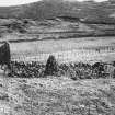
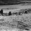
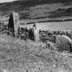
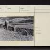
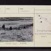
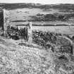
Standing Stones, Glac Mhor, Dervaig: On Glac Mhor, 850m ESE of Dervaig and 400m S of NM45SW 4, there are four stones, three of which (A - C on plan) are approximately on a line running NNW and SSE. Stone A, which is now embedded in a dyke, is 1.07m high and 0.8m by 0.5m at ground-level. Although it was originally taller, stone B is now 1.3m high and measures 0.65m in breadth by 0.6m in thickness. Stone C is a shattered block 1m high and 1.15m by 1.1m at the base. The fourth stone (D) forms one side of a gate-way through the wall and is probably not in its original position; it measures 1.1m in height and 0.8m by 0.8m at the foot.
RCAHMS 1980, visited 1972
When seen in April 1972, these stones were in a similar condition to that described by the RCAHMS. They do not form a stone circle, but an alignment similar to those described on NM45SW 4 and NM45SW 5.
Surveyed at 1:2500.
Visited by OS (RD) 27 April 1972
Field Visit (3 July 1943)
This site was included within the RCAHMS Emergency Survey (1942-3), an unpublished rescue project. Site descriptions, organised by county, vary from short notes to lengthy and full descriptions and are available to view online with contemporary sketches and photographs. The original typescripts, manuscripts, notebooks and photographs can also be consulted in the RCAHMS Search Room.
Information from RCAHMS (GFG) 10 December 2014.


