
Pricing Change
New pricing for orders of material from this site will come into place shortly. Charges for supply of digital images, digitisation on demand, prints and licensing will be altered.
Dun Nan Gall, Mull


Broch (Iron Age)
Site Name Dun Nan Gall, Mull
Classification Broch (Iron Age)
Canmore ID 22058
Site Number NM44SW 2
NGR NM 4331 4313
Datum OSGB36 - NGR
Permalink http://canmore.org.uk/site/22058


- Council Argyll And Bute
- Parish Kilninian And Kilmore
- Former Region Strathclyde
- Former District Argyll And Bute
- Former County Argyll
NM44SW 2 4331 4313.
(NM 4331 4313) Dun nan Gall (NAT) Broch (NR)
OS 1:10,000 map, (1976)
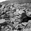
Broch, Dun nan Gall: Occupying the summit of a low knoll at the NW end of a rocky coastal promontory about 700m WNW of Kilbrenan farmhouse, and only 3m above sea-level, there are the conspicuous remains of a broch. The position is not one of great natural strength.
The broch measures 10.4m in diameter within a well-built dry-stone wall which varies from 3.0m to 4.1m in thickness. Almost the entire circuit of both the outer and inner faces can still be traced. The best preserved sector of the former is on the N, where it rises to a height of 1.2m in eight courses. The latter, however, which has been exposed by comparatively recent excavation, is in a much better state of preservation and stands as much as 1.8m high in ten courses; at an average height of 0.6m above the interior it exhibits a scarement, 0.2m wide, formed by a series of projecting slabs supported on slight corbelling. It is noteworthy that the entire SE quadrant of the scarcement is set one course, or 0.3m, higher than the rest.
The entrance, which has been checked for a door, is situated on the E; it measures about 1.2m wide at both the inner and outer ends but increases to 1.5m immediately inside the checks. On the S side a passage, about 1.0m wide, opens from the interior at ground level and gives access to a stair which leads upwards in the thickness of the wall. Of the other five openings in the inner face, all but that on the NNE apear to have been merely voids or relieving slits in the upper portion of the wall, but the last, 0.9m wide, may have served as the entrance to an intramural gallery, traces of which can be seen at scarcement level round almost the entire circuit.
The interior is obscured by piles of tumbled core-material, and a considerable quantity of wall debris also covers the flanks of the knoll on all sides. A modern dyke has been built on top of the ruins of the broch wall on the NE.
R W Feachem 1963; J Duns 1883; V G Childe and A Graham 1943; RCAHMS 1980, visited 1974.
Dun nan Gall, a broch. Name confirmed.
Revised at 1:2500.
Visited by OS (RD) 12 May 1972.
Field Visit (8 August 1934)
A certain broch on rocky promontory with on either side and low marsh behind. Walls still standing to S and above line of well marked scarcement, 10' 6" thick. Entrance 3'10" inside 3'4" outside jambs project 6" and 4" respect 3' 2/3" from outer guard cell (choked) on right. In wall on left at centre (23' chord from left inner door jamb to nearest corner of) entrance passage 3'4" leads to cell 3'1" wide with stair counter-clock wise on left.
Field Visit (27 July 1942)
This site was included within the RCAHMS Emergency Survey (1942-3), an unpublished rescue project. Site descriptions, organised by county, vary from short notes to lengthy and full descriptions and are available to view online with contemporary sketches and photographs. The original typescripts, manuscripts, notebooks and photographs can also be consulted in the RCAHMS Search Room.
Information from RCAHMS (GFG) 10 December 2014.
Publication Account (2007)
NM44 2 DUN NAN GALL
NM/4331 4313
This broch in Kilninian and Kilmore stands on flat ground on a short. low promontory on a flat, rocky shore; the site stands only 3m above sea level (visited 5/6/64 and 6/10/89). There are two short sea inlets on either side though neither seems very deep, and there are no cliffs or steep rock faces anywhere near. At low tide the surrounding shallows do not provide an effective barrier to approaching the broch. Most of the inner and outer faces can be seen. The structure is reported to have been partly excavated by J Hewat Craw but that his untimely death prevented completion.
Description
Level 1. The entrance passage faces east-south-east, that is, land-wards, along the promontory, and the built checks of the door-frame are visible 1.2m (4 ft) from the exterior, together with the deep bar-hole on the right and the socket opposite this. The lintels covering the bar-holes are now visible from above. The passage is 1.2m wide at both the inner and the outer end but immediately behind the door-frame it widens to 1.5m; the roofing lintels are displaced. The passage length is 3.2m. There are no signs of any doors to guard chambers.
The structure of the wall at ground-level is unclear. Judging from the absence of a gallery at the stair door (below) the wall could be solid-based but the relative thinness of the wall suggests a Hebridean ground-galleried broch. The door to the mural stair from the Central court is visible at 9 o’clock as are a few of the steps, rising to the right; two lintels were still in position over the latter, and the wall corbels out very slightly below them. It is clear that there is no stair-foot guard cell and there are no signs of a ground-level mural gallery running anti-clockwise from the stair.
Level 2. A ledge scarcement about 20cm wide can be seen to run almost the whole way round the inner wallface. It is unusual in that one entire quadrant – from the left of the entrance to the stair door – is one course of stones (c. 30cm) higher than the rest (suggesting that the underlying rock is higher here). There are traces of the upper gallery nearly all the way round and five more openings from it to the Central court are described [5], at about 10, 11, 12.30, 2.30 and 4 o’clock, and the Commission considered that most of them were mere voids in the wall. In 1989 the only such opening clearly visible was that at 11.30 o’clock; the sill and the sides were exposed. The relationship of the floor of this doorway to the adjacent scarcement is unusual in that the latter is about 30cm above the former.
From 2.30 - 3.30 o’clock a stretch of gallery – 90cm (3 ft) wide – can be seen which is clearly above the scarcement. It appears again at about 5 o’clock and runs up to the entrance passage with its floor at scarcement level. At this point it may have connected with a chamber over the entrance (the inner face is broken for the last 60cm, or 2 ft) and there is therefore little likelihood of there being a domed guard cell on the left of the passage.
Discussion
The structure is clearly a broch, with an upper gallery visible. The raised doorway at 11.30 o’clock must surely have led from a landing in the intramural stairway out on to the wooden floor resting on the scarcement – by way of a step up in this case.
Dimensions: overall diameter from 6-12 o’clock is 17.2m (56.5 ft), internal 10.4m (34 ft): from 9-3 o’clock the figures are 17.7m (58 ft) and 12.8m (42 ft) respectively [5]. The wall proportion on the first diameter is thus 40%. In 1989 a new survey of the Central court was undertaken but the results have not yet been analysed.
Sources: 1. NMRS site no. NM 44 SW 2: 2. Duns 1883, 86-7: 3. Childe and Graham 1943, 40: 4. Feachem 1963, 166: 5. RCAHMS 1980, 94-5, no. 168, fig. 92 and pl. 14, E, F and G .
E W MacKie 2007

