
Pricing Change
New pricing for orders of material from this site will come into place shortly. Charges for supply of digital images, digitisation on demand, prints and licensing will be altered.
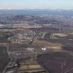
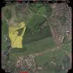
Danderhall Village


Village (Period Unassigned)
Site Name Danderhall Village
Classification Village (Period Unassigned)
Canmore ID 220466
Site Number NT36NW 136
NGR NT 3090 6938
NGR Description Centred NT 3090 6938
Datum OSGB36 - NGR
Permalink http://canmore.org.uk/site/220466


- Council Midlothian
- Parish Newton
- Former Region Lothian
- Former District Midlothian
- Former County Midlothian
NT36NW 136 centred 3090 6938
Danderhall village is visible on a vertical air phtograph (OS 75/292/44, flown 1975).
Information from RCAHMS

