
Kilmarnock, St Andrew's Street, St Andrew's Parish Church And Churchyard


Church (Period Unassigned), Churchyard (Period Unassigned), War Memorial (20th Century)
Site Name Kilmarnock, St Andrew's Street, St Andrew's Parish Church And Churchyard
Classification Church (Period Unassigned), Churchyard (Period Unassigned), War Memorial (20th Century)
Alternative Name(s) Church Of Scotland; St Andrew's And Glencairn; St Andrew's Free Church; War Memorial Panelling
Canmore ID 220360
Site Number NS43NW 298
NGR NS 42986 37268
Datum OSGB36 - NGR
Permalink http://canmore.org.uk/site/220360
Ordnance Survey licence number AC0000807262. All rights reserved.
Canmore Disclaimer.
© Bluesky International Limited 2025. Public Sector Viewing Terms
- Correction
- Favourite

SC 1383252
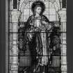
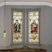
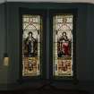
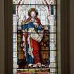
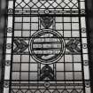
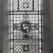
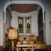
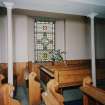
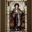
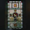
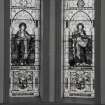
Interior. Detail of stained glass window
Records of the Royal Commission on the Ancient and Historical Monuments of Scotland (RCAHMS), Edinbu
1/10/2002
© Crown Copyright: HES

SC 1385262
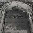
Detail of John (Johnnie) Walker's gravestone
Records of the Royal Commission on the Ancient and Historical Monuments of Scotland (RCAHMS), Edinbu
1/10/2002
© Crown Copyright: HES

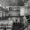
SC 1385264
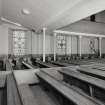
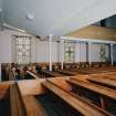
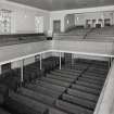
Interior. View of interior from E showing pews and galleries
Records of the Royal Commission on the Ancient and Historical Monuments of Scotland (RCAHMS), Edinbu
1/10/2002
© Crown Copyright: HES

SC 1385267
Interior. View of gallery and columns from S
Records of the Royal Commission on the Ancient and Historical Monuments of Scotland (RCAHMS), Edinbu
1/10/2002
© Crown Copyright: HES

SC 1385270
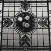
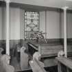
Interior. Detail of gallery stained glass window with flowers
Records of the Royal Commission on the Ancient and Historical Monuments of Scotland (RCAHMS), Edinbu
1/10/2002
© Crown Copyright: HES

SC 1385280
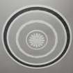
Interior. Detail of ceiling rose
Records of the Royal Commission on the Ancient and Historical Monuments of Scotland (RCAHMS), Edinbu
1/10/2002
© Crown Copyright: HES

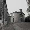
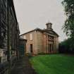
SC 2612462
View from WNW showing church and halls
Records of the Royal Commission on the Ancient and Historical Monuments of Scotland (RCAHMS), Edinbu
1/10/2002
© Crown Copyright: HES

SC 2612467
View from NNE
Records of the Royal Commission on the Ancient and Historical Monuments of Scotland (RCAHMS), Edinbu
1/10/2002
© Crown Copyright: HES

SC 2612479
Interior. View of gallery and columns from S
Records of the Royal Commission on the Ancient and Historical Monuments of Scotland (RCAHMS), Edinbu
1/10/2002
© Crown Copyright: HES

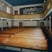
SC 2612482
Interior. View of interior and gallery from W gallery showing raked seating
Records of the Royal Commission on the Ancient and Historical Monuments of Scotland (RCAHMS), Edinbu
1/10/2002
© Crown Copyright: HES

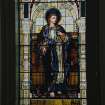
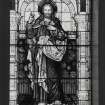
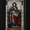
SC 2612496
Interior. Detail of chancel stained glass windows in memoory of Archibald Finnie of Springhill and of Archibald Finnie of Kilmarnock
Records of the Royal Commission on the Ancient and Historical Monuments of Scotland (RCAHMS), Edinbu
1/10/2002
© Crown Copyright: HES

SC 1385268
Interior. Detail of stained glass window with texr
Records of the Royal Commission on the Ancient and Historical Monuments of Scotland (RCAHMS), Edinbu
1/10/2002
© Crown Copyright: HES

SC 1385274
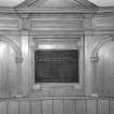
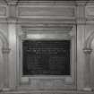
Interior. Detail of war memorial in apse war memorial panelling
Records of the Royal Commission on the Ancient and Historical Monuments of Scotland (RCAHMS), Edinbu
1/10/2002
© Crown Copyright: HES

SC 1385276
Interior. Detail of chancel stained glass windows in memoory of Archibald Finnie of Springhill and of Archibald Finnie of Kilmarnock
Records of the Royal Commission on the Ancient and Historical Monuments of Scotland (RCAHMS), Edinbu
1/10/2002
© Crown Copyright: HES

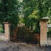
SC 2612454
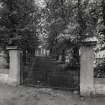
View from WSW including entrance gates
Records of the Royal Commission on the Ancient and Historical Monuments of Scotland (RCAHMS), Edinbu
1/10/2002
© Crown Copyright: HES

SC 2612477
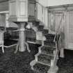
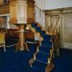
Interior. Detail of "wineglass" pulpit
Records of the Royal Commission on the Ancient and Historical Monuments of Scotland (RCAHMS), Edinbu
1/10/2002
© Crown Copyright: HES

SC 2612483
Interior. View of interior and gallery from W gallery showing raked seating
Records of the Royal Commission on the Ancient and Historical Monuments of Scotland (RCAHMS), Edinbu
1/10/2002
© Crown Copyright: HES

SC 2612486
Interior. Detail of gallery stained glass window with pomegranates
Records of the Royal Commission on the Ancient and Historical Monuments of Scotland (RCAHMS), Edinbu
1/10/2002
© Crown Copyright: HES

SC 2612497
Interior. Detail of chancel stained glass windows.Interior. Detail of chancel stained glass windows in memoory of Archibald Finnie of Springhill and of Archibald Finnie of Kilmarnock
Records of the Royal Commission on the Ancient and Historical Monuments of Scotland (RCAHMS), Edinbu
1/10/2002
© Crown Copyright: HES

SC 2612498
Interior. Detail of chancel stained glass windows in memoory of Archibald Finnie of Springhill and of Archibald Finnie of Kilmarnock
Records of the Royal Commission on the Ancient and Historical Monuments of Scotland (RCAHMS), Edinbu
1/10/2002
© Crown Copyright: HES

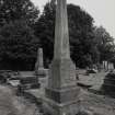
SC 1385260
Detail of Green family monument
Records of the Royal Commission on the Ancient and Historical Monuments of Scotland (RCAHMS), Edinbu
1/10/2002
© Crown Copyright: HES

SC 1385272
Interior. Detail of cast iron gallery columns
Records of the Royal Commission on the Ancient and Historical Monuments of Scotland (RCAHMS), Edinbu
1/10/2002
© Crown Copyright: HES

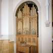
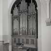
SC 1385279
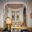
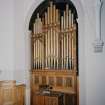
Interior. Detail of organ
Records of the Royal Commission on the Ancient and Historical Monuments of Scotland (RCAHMS), Edinbu
1/10/2002
© Crown Copyright: HES

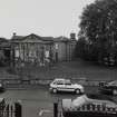
SC 2612453
General view from W showing halls and church
Records of the Royal Commission on the Ancient and Historical Monuments of Scotland (RCAHMS), Edinbu
1/10/2002
© Crown Copyright: HES

SC 2612472
Interior. View from E showing pulpit communion table and galleries
Records of the Royal Commission on the Ancient and Historical Monuments of Scotland (RCAHMS), Edinbu
1/10/2002
© Crown Copyright: HES

SC 2612489
Interior. Detail of apse war memorial panelling
Records of the Royal Commission on the Ancient and Historical Monuments of Scotland (RCAHMS), Edinbu
1/10/2002
© Crown Copyright: HES

SC 2612495
Interior. Detail of chancel stained glass windows in memoory of Archibald Finnie of Springhill and of Archibald Finnie of Kilmarnock
Records of the Royal Commission on the Ancient and Historical Monuments of Scotland (RCAHMS), Edinbu
1/10/2002
© Crown Copyright: HES

SC 2612499
Interior. Detail of chancel stained glass windows.Interior. Detail of chancel stained glass windows in memoory of Archibald Finnie of Springhill and of Archibald Finnie of Kilmarnock
Records of the Royal Commission on the Ancient and Historical Monuments of Scotland (RCAHMS), Edinbu
1/10/2002
© Crown Copyright: HES

SC 2612500
Interior. Detail of organ
Records of the Royal Commission on the Ancient and Historical Monuments of Scotland (RCAHMS), Edinbu
1/10/2002
© Crown Copyright: HES

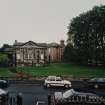
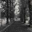
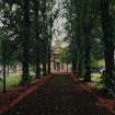
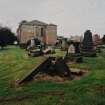
SC 1385253
View from WSW showing avenue leading to church
Records of the Royal Commission on the Ancient and Historical Monuments of Scotland (RCAHMS), Edinbu
1/10/2002
© Crown Copyright: HES

SC 1385259
View from NNE
Records of the Royal Commission on the Ancient and Historical Monuments of Scotland (RCAHMS), Edinbu
1/10/2002
© Crown Copyright: HES

SC 1385261
Detail of Lee family monument
Records of the Royal Commission on the Ancient and Historical Monuments of Scotland (RCAHMS), Edinbu
1/10/2002
© Crown Copyright: HES

SC 1385271
Interior. Detail of gallery stained glass window with pomegranates
Records of the Royal Commission on the Ancient and Historical Monuments of Scotland (RCAHMS), Edinbu
1/10/2002
© Crown Copyright: HES

SC 1385278
Interior. Detail of chancel stained glass windows.Interior. Detail of chancel stained glass windows in memoory of Archibald Finnie of Springhill and of Archibald Finnie of Kilmarnock
Records of the Royal Commission on the Ancient and Historical Monuments of Scotland (RCAHMS), Edinbu
1/10/2002
© Crown Copyright: HES

SC 2612452
General view from W showing halls and church
Records of the Royal Commission on the Ancient and Historical Monuments of Scotland (RCAHMS), Edinbu
1/10/2002
© Crown Copyright: HES

SC 2612456
View from WSW showing avenue leading to church
Records of the Royal Commission on the Ancient and Historical Monuments of Scotland (RCAHMS), Edinbu
1/10/2002
© Crown Copyright: HES

SC 2612457
View from WSW showing avenue leading to church
Records of the Royal Commission on the Ancient and Historical Monuments of Scotland (RCAHMS), Edinbu
1/10/2002
© Crown Copyright: HES

SC 2612459
View from W showing entrance and N front
Records of the Royal Commission on the Ancient and Historical Monuments of Scotland (RCAHMS), Edinbu
1/10/2002
© Crown Copyright: HES

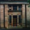
SC 2612461
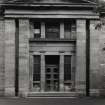
View of pedimeted W entrance front
Records of the Royal Commission on the Ancient and Historical Monuments of Scotland (RCAHMS), Edinbu
1/10/2002
© Crown Copyright: HES

SC 2612463
View from WNW showing church and halls
Records of the Royal Commission on the Ancient and Historical Monuments of Scotland (RCAHMS), Edinbu
1/10/2002
© Crown Copyright: HES

SC 2612468
Detail of Green family monument
Records of the Royal Commission on the Ancient and Historical Monuments of Scotland (RCAHMS), Edinbu
1/10/2002
© Crown Copyright: HES

SC 2612470
Detail of John (Johnnie) Walker's gravestone
Records of the Royal Commission on the Ancient and Historical Monuments of Scotland (RCAHMS), Edinbu
1/10/2002
© Crown Copyright: HES

SC 2612481
Interior. Detail of stained glass window with texr
Records of the Royal Commission on the Ancient and Historical Monuments of Scotland (RCAHMS), Edinbu
1/10/2002
© Crown Copyright: HES

SC 2612502
Interior. Detail of ceiling rose
Records of the Royal Commission on the Ancient and Historical Monuments of Scotland (RCAHMS), Edinbu
1/10/2002
© Crown Copyright: HES

SC 1383251
Interior. Detail of ceiling rose
Records of the Royal Commission on the Ancient and Historical Monuments of Scotland (RCAHMS), Edinbu
1/10/2002
© Crown Copyright: HES

SC 1385254
View from W showing entrance and N front
Records of the Royal Commission on the Ancient and Historical Monuments of Scotland (RCAHMS), Edinbu
1/10/2002
© Crown Copyright: HES

SC 1385257
View from N
Records of the Royal Commission on the Ancient and Historical Monuments of Scotland (RCAHMS), Edinbu
1/10/2002
© Crown Copyright: HES

SC 1385269
Interior. View of interior and gallery from W gallery showing raked seating
Records of the Royal Commission on the Ancient and Historical Monuments of Scotland (RCAHMS), Edinbu
1/10/2002
© Crown Copyright: HES

SC 2612464
View from N
Records of the Royal Commission on the Ancient and Historical Monuments of Scotland (RCAHMS), Edinbu
1/10/2002
© Crown Copyright: HES

SC 2612480
Interior. View of gallery and columns from S
Records of the Royal Commission on the Ancient and Historical Monuments of Scotland (RCAHMS), Edinbu
1/10/2002
© Crown Copyright: HES

SC 2612484
Interior. Detail of gallery stained glass window with flowers
Records of the Royal Commission on the Ancient and Historical Monuments of Scotland (RCAHMS), Edinbu
1/10/2002
© Crown Copyright: HES

SC 2612487
Interior. Detail of cast iron gallery columns
Records of the Royal Commission on the Ancient and Historical Monuments of Scotland (RCAHMS), Edinbu
1/10/2002
© Crown Copyright: HES

SC 2612492
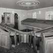
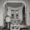
Interior. View of chancel from SW
Records of the Royal Commission on the Ancient and Historical Monuments of Scotland (RCAHMS), Edinbu
1/10/2002
© Crown Copyright: HES

SC 2612493
Interior. View of chancel from SW
Records of the Royal Commission on the Ancient and Historical Monuments of Scotland (RCAHMS), Edinbu
1/10/2002
© Crown Copyright: HES

SC 1385252
View from WSW including entrance gates
Records of the Royal Commission on the Ancient and Historical Monuments of Scotland (RCAHMS), Edinbu
1/10/2002
© Crown Copyright: HES

SC 1385265
Interior. View of interior from NE from N gallery
Records of the Royal Commission on the Ancient and Historical Monuments of Scotland (RCAHMS), Edinbu
1/10/2002
© Crown Copyright: HES

SC 2612455
View from WSW including entrance gates
Records of the Royal Commission on the Ancient and Historical Monuments of Scotland (RCAHMS), Edinbu
1/10/2002
© Crown Copyright: HES

SC 2612473
Interior. View of interior from E showing pews and galleries
Records of the Royal Commission on the Ancient and Historical Monuments of Scotland (RCAHMS), Edinbu
1/10/2002
© Crown Copyright: HES

SC 2612474
Interior. View of interior from E showing pews and galleries
Records of the Royal Commission on the Ancient and Historical Monuments of Scotland (RCAHMS), Edinbu
1/10/2002
© Crown Copyright: HES

SC 2612478
Interior. Detail of "wineglass" pulpit
Records of the Royal Commission on the Ancient and Historical Monuments of Scotland (RCAHMS), Edinbu
1/10/2002
© Crown Copyright: HES

SC 2612488
Interior. Detail of cast iron gallery columns
Records of the Royal Commission on the Ancient and Historical Monuments of Scotland (RCAHMS), Edinbu
1/10/2002
© Crown Copyright: HES

SC 2612491
Interior. Detail of war memorial in apse war memorial panelling
Records of the Royal Commission on the Ancient and Historical Monuments of Scotland (RCAHMS), Edinbu
1/10/2002
© Crown Copyright: HES

SC 1385256
View from WNW showing church and halls
Records of the Royal Commission on the Ancient and Historical Monuments of Scotland (RCAHMS), Edinbu
1/10/2002
© Crown Copyright: HES

SC 1385266
Interior. Detail of "wineglass" pulpit
Records of the Royal Commission on the Ancient and Historical Monuments of Scotland (RCAHMS), Edinbu
1/10/2002
© Crown Copyright: HES

SC 1385275
Interior. View of chancel from SW
Records of the Royal Commission on the Ancient and Historical Monuments of Scotland (RCAHMS), Edinbu
1/10/2002
© Crown Copyright: HES

SC 1385277
Interior. Detail of chancel stained glass windows.Interior. Detail of chancel stained glass windows in memoory of Archibald Finnie of Springhill and of Archibald Finnie of Kilmarnock
Records of the Royal Commission on the Ancient and Historical Monuments of Scotland (RCAHMS), Edinbu
1/10/2002
© Crown Copyright: HES

SC 2612460
View of pedimeted W entrance front
Records of the Royal Commission on the Ancient and Historical Monuments of Scotland (RCAHMS), Edinbu
1/10/2002
© Crown Copyright: HES

SC 2612475
Interior. View of interior from NE from N gallery
Records of the Royal Commission on the Ancient and Historical Monuments of Scotland (RCAHMS), Edinbu
1/10/2002
© Crown Copyright: HES

SC 2612476
Interior. View of interior from NE from N gallery
Records of the Royal Commission on the Ancient and Historical Monuments of Scotland (RCAHMS), Edinbu
1/10/2002
© Crown Copyright: HES

SC 2612501
Interior. Detail of organ
Records of the Royal Commission on the Ancient and Historical Monuments of Scotland (RCAHMS), Edinbu
1/10/2002
© Crown Copyright: HES

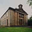
SC 1385251
General view from W showing halls and church
Records of the Royal Commission on the Ancient and Historical Monuments of Scotland (RCAHMS), Edinbu
1/10/2002
© Crown Copyright: HES

SC 1385255
View of pedimeted W entrance front
Records of the Royal Commission on the Ancient and Historical Monuments of Scotland (RCAHMS), Edinbu
1/10/2002
© Crown Copyright: HES

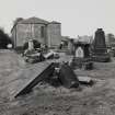
SC 1385258
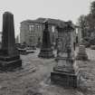
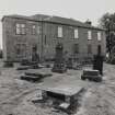
View from E showing apse and vestry wing within vandalised graveyard
Records of the Royal Commission on the Ancient and Historical Monuments of Scotland (RCAHMS), Edinbu
1/10/2002
© Crown Copyright: HES

SC 1385273
Interior. Detail of apse war memorial panelling
Records of the Royal Commission on the Ancient and Historical Monuments of Scotland (RCAHMS), Edinbu
1/10/2002
© Crown Copyright: HES

SC 2612458
View from W showing entrance and N front
Records of the Royal Commission on the Ancient and Historical Monuments of Scotland (RCAHMS), Edinbu
1/10/2002
© Crown Copyright: HES

SC 2612465
View from E showing apse and vestry wing within vandalised graveyard
Records of the Royal Commission on the Ancient and Historical Monuments of Scotland (RCAHMS), Edinbu
1/10/2002
© Crown Copyright: HES

SC 2612466
View from E showing apse and vestry wing within vandalised graveyard
Records of the Royal Commission on the Ancient and Historical Monuments of Scotland (RCAHMS), Edinbu
1/10/2002
© Crown Copyright: HES

SC 2612469
Detail of Lee family monument
Records of the Royal Commission on the Ancient and Historical Monuments of Scotland (RCAHMS), Edinbu
1/10/2002
© Crown Copyright: HES

SC 2612485
Interior. Detail of gallery stained glass window with flowers
Records of the Royal Commission on the Ancient and Historical Monuments of Scotland (RCAHMS), Edinbu
1/10/2002
© Crown Copyright: HES

SC 2612490
Interior. Detail of apse war memorial panelling
Records of the Royal Commission on the Ancient and Historical Monuments of Scotland (RCAHMS), Edinbu
1/10/2002
© Crown Copyright: HES

SC 2612494
Interior. Detail of chancel stained glass windows in memoory of Archibald Finnie of Springhill and of Archibald Finnie of Kilmarnock
Records of the Royal Commission on the Ancient and Historical Monuments of Scotland (RCAHMS), Edinbu
1/10/2002
© Crown Copyright: HES


- Council East Ayrshire
- Parish Kilmarnock
- Former Region Strathclyde
- Former District Kilmarnock And Loudoun
- Former County Ayrshire
NS43NW 298.00 42986 37268
NS43NW 298.01 42955 37280 Hall

