
Ulva, Ormaig


Township (Period Unassigned)
Site Name Ulva, Ormaig
Classification Township (Period Unassigned)
Canmore ID 22015
Site Number NM43NW 14
NGR NM 430 397
NGR Description Centred on NM 430 397
Datum OSGB36 - NGR
Permalink http://canmore.org.uk/site/22015


- Council Argyll And Bute
- Parish Kilninian And Kilmore
- Former Region Strathclyde
- Former District Argyll And Bute
- Former County Argyll
NM43NW 14 centred on 430 397
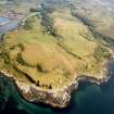
(NM 430 395) A depopulated settlement consisting of about five roofless buildings.
Visited by OS 11 May 1972
A township comprising ten unroofed buildings and one enclosure is depicted on the 1st edition of the OS 6-inch map (Argyllshire, Island of Mull 1882, sheet lxxxii). Six unroofed buildings and one enclosure are shown on the current edition of the OS 1:10000 map (1976).
Information from RCAHMS (SAH) 1 July 1998
Site recorded during survey for the Scottish Agricultural College, under the Historic Scotland Ancient Monument Survey Grant Scheme.
NM 430 396 Deserted settlement
Sponsors: Historic Scotland, Scottish Agricultural College.
T Rees 1998
Field Walking (1 April 2011 - 30 May 2011)
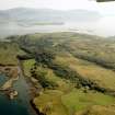
NM 4335 3975 (Area 1 – centred on) and NM 42298 39674 (Area 2 – centred on) A walkover survey was carried out 1 April–30 May 2011 in advance of woodland establishment schemes. The work was undertaken to assess the nature and extent of any archaeology likely to be affected by the scheme and to inform recommendations for the protection and management of any sites. The survey identified sites previously recorded by AOC Archaeology Group in 1998 and new sites relating to post-medieval settlement on the island.
The total number of sites identified and recorded during the walkover survey included 22 houses, 17 byres, 13 bothies, 2 kale yards, 28 shielings, 5 pens, 8 enclosures, 49 boundary walls, 49 areas of rig and furrow cultivation, 3 wells, 2 sheep fanks, 1 jetty, 1 track and numerous clearance cairns. The only prehistoric site of note was a previously recorded standing stone.
The density of the remains indicates a well preserved settlement system of regional importance including infrastructure associated with the cultivation and modification of the land. This includes a complex of small settlements, individual farmsteads, houses and their associated ancillary buildings, enclosures and cultivation plots, and shielings possibly relating to several phases of occupation.
The major settlements identified appear to relate to Soriby Bay and Aird Glass. Beyond the enclosures and areas of major settlement we did find the ephemeral remains of bothies, shielings and rock shelters that were probably associated with transhumance activities within the wider landscape. Some of this activity was centred on areas of enclosure, some of which may have consisted of areas of grazing for livestock, but which generally consisted of areas of rig and furrow cultivation. In addition to these sites, we did recover some evidence for the connectivity with the sea in the form of a jetty and cleared areas on the foreshore for boat landings.
Some of the areas of rig and furrow were enclosed with dry stone, and turf and stone dykes, while natural rock outcrops and escarpments had also been utilised within the enclosure system. The majority of the rigs or lazy beds appear to have been hand-dug, making use of the better quality ground, while the interspersed furrows would have provided drainage channels for water run-off. Clearance cairns were also identified associated with some of the improved land.
A complex of field boundaries and enclosure walls complete the archaeological record and indicate the phased division of the landscape through time. The walls were of dry stone, turf and stone construction, and varied significantly in their preservation, while some of the walls displayed good evidence for phasing.
Archive: RCAHMS and WoSAS (intended)
Funder: Ulva Estates, Mull
West Coast Archaeological Services, 2011
westcoas1-99096

