
Pricing Change
New pricing for orders of material from this site will come into place shortly. Charges for supply of digital images, digitisation on demand, prints and licensing will be altered.
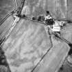
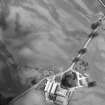
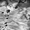
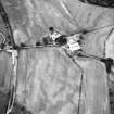
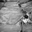
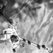
Trailflat


Cropmark(S) (Period Unknown), Quarry(S) (Period Unassigned)
Site Name Trailflat
Classification Cropmark(S) (Period Unknown), Quarry(S) (Period Unassigned)
Canmore ID 219899
Site Number NY08NW 39
NGR NY 04964 85063
Datum OSGB36 - NGR
Permalink http://canmore.org.uk/site/219899


- Council Dumfries And Galloway
- Parish Tinwald
- Former Region Dumfries And Galloway
- Former District Nithsdale
- Former County Dumfries-shire
Aerial Photographic Transcription (17 July 2012)
These features of indiscriminate origin have been recorded as cropmarks on oblique aerial photographs (RCAHMSAP 1983, 1984).
Information from RCAHMS (KHJM) 17 July 2012

