
Following the launch of trove.scot in February 2025 we are now planning the retiral of some of our webservices. Canmore will be switched off on 24th June 2025. Information about the closure can be found on the HES website: Retiral of HES web services | Historic Environment Scotland
Cranshaws Farm, Stable Courtyard


Farmstead (Period Unassigned), Stable (Period Unassigned)
Site Name Cranshaws Farm, Stable Courtyard
Classification Farmstead (Period Unassigned), Stable (Period Unassigned)
Canmore ID 219804
Site Number NT66SE 19.02
NGR NT 68215 61824
Datum OSGB36 - NGR
Permalink http://canmore.org.uk/site/219804


- Council Scottish Borders, The
- Parish Cranshaws
- Former Region Borders
- Former District Berwickshire
- Former County Berwickshire
Standing Building Recording (21 October 2016)
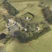
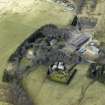
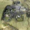
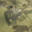
NT 68232 61827 A standing building survey was undertaken, 21 October 2016, of the former stable block in advance of its renovation. Cranshaws Farm Steading was constructed between 1826 and 1862 to the NE of the
ruins of Cranshaws Castle, which dates from the 14th/16th centuries. It was built as a self-contained courtyard steading accompanied by a large farmhouse to the SW, and consists of four distinct blocks, including at least two stable blocks and other barns. Later conversions to cow byres also took place within the stable buildings, but the original ventilation windows to the westernmost block still survive intact.
Archive: NRHE (intended)
Funder: BH Sporting Ltd
Diana Sproat – AOC Archaeology Group
(Source: DES, Volume 17)

