
Pricing Change
New pricing for orders of material from this site will come into place shortly. Charges for supply of digital images, digitisation on demand, prints and licensing will be altered.
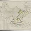
Cothill


Farmhouse (Period Unassigned), Farmstead (Period Unassigned)
Site Name Cothill
Classification Farmhouse (Period Unassigned), Farmstead (Period Unassigned)
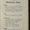
Alternative Name(s) Cothill Farm; Marchmont Estate
Canmore ID 219797
Site Number NT74NE 22
NGR NT 76154 49936
Datum OSGB36 - NGR
Permalink http://canmore.org.uk/site/219797


- Council Scottish Borders, The
- Parish Polwarth
- Former Region Borders
- Former District Berwickshire
- Former County Berwickshire
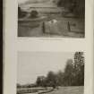
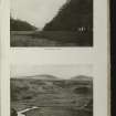
Cothill farm was once part of the Marchmont Estate and is situated near the eastern end of the Marchmont Avenue. The farm buildings probably date from the late eighteenth or nineteenth century.
The Ordnance Survey name book, compiled in the mid-nineteenth century by the surveyors producing the 1st edition map, records that the farmhouse was 'comfortable' and that it was named after the nearby dovecot, which is situated at the very end of Marchmont Avenue.
Text prepared by RCAHMS as part of the Accessing Scotland's Past project

