
Dun A' Gheird, Mull


Galleried Dun (Iron Age)
Site Name Dun A' Gheird, Mull
Classification Galleried Dun (Iron Age)
Alternative Name(s) Dun Nan Geard; Dun A' Geard
Canmore ID 21974
Site Number NM41NW 2
NGR NM 4062 1889
Datum OSGB36 - NGR
Permalink http://canmore.org.uk/site/21974


- Council Argyll And Bute
- Parish Kilfinichen And Kilvickeon
- Former Region Strathclyde
- Former District Argyll And Bute
- Former County Argyll
NM41NW 2 4062 1889.
(NM 4062 1889) Dun nan Geard (NR)
OS 6" map (1900)
This dun is wrongly named Dun nan Ceard. MacCormick calls it Dun a' Gheird, and Mrs U Betts (information from letter of 25 February 1961) states that this name is in use locally.
J MacCormick 1923
The name Dun a' Gheird is in use locally.
Surveyed at 1:10,000.
Visited by OS (DWR) 4 June 1972
(NM 4062 1889) Dun a' Gheird (NR)
OS 1:10000 map (1976)
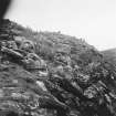
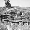
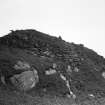
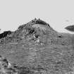
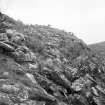
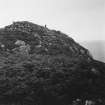
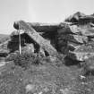
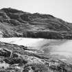
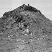
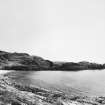
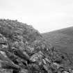
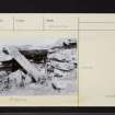
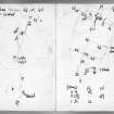
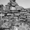
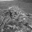
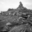
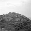
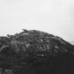
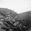
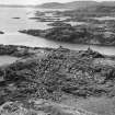
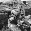
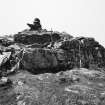
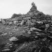
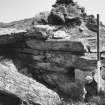
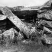
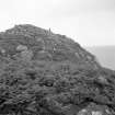
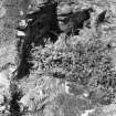
Dun, Dun a'Geard: The well-preserved remains of this galleried dun occupy a low boss on the S end of a steep-sided rocky spur about 1 km SW of Kilvickeon Old Parish Church. The dun is roughly sub-rectangular on plan and measures 11m from NNE to SSW by about 9m transversely within a stone wall which varies in thickness from about 4.3m on the N to about 2.4m on the S. Much of the circuit of the outer face can still be traced; on the N it rises 0.7m above the level of the debris outside. Only a few inner facing-stones can be seen. In the thickness of the wall at various points, as shown on the plan, there are traces of an intramural gallery, which may originally have continued round the entire circuit. At the present time it is best preserved on the S, where it stands 0.6m high, and several of the roofing-lintels are still in position.
There are two entrances, diametrically opposed, in the NE and SW. The W passage-wall of the northernmost one is particularly well-preserved, standing to a maximum height of 1.2m in ten courses.
A massive boulder-faced, rubble-cored revetting wall at least 1.8m thick has been built against the dun wall on the N.
RCAHMS 1980, visited 1974.
Field Visit (24 June 1943)
This site was included within the RCAHMS Emergency Survey (1942-3), an unpublished rescue project. Site descriptions, organised by county, vary from short notes to lengthy and full descriptions and are available to view online with contemporary sketches and photographs. The original typescripts, manuscripts, notebooks and photographs can also be consulted in the RCAHMS Search Room.
Information from RCAHMS (GFG) 10 December 2014.
Publication Account (2007)
NM41 1 DUN a’ GEARD
NM/4062 1889
The author originally thought that this site might be a semibroch of unusual type but the Commission’s interpretation as a “galleried dun” (in Kilfinichen and Kilvickeon) situated on a narrow ridge – and with two opposed entrances looking along it – now seems more plausible (visited 7/6/64). A detailed description is available [2].
Sources: 1. NMRS site no NM 41 NW 2: 2. RCAHMS 1980, 100-01, no. 185 and fig. 106.
E W MacKie 2007

