 |
On-line Digital Images |
SC 1013386 |
Records of Aberdeen Aerial Surveys, Aberdeen, Scotland |
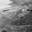
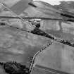
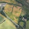
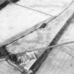
Oblique aerial view centred on the cropmarks of the Roman Temporary Camp, unenclosed settlement, linear features, pits and rig at Gilrivie, looking to the SW. |
5/7/1982 |
Item Level |
|
 |
On-line Digital Images |
SC 1013389 |
Records of Aberdeen Aerial Surveys, Aberdeen, Scotland |
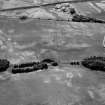
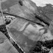
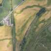
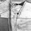
Oblique aerial view centred on the cropmarks of the Roman Temporary Camp, linear features, enclosure, pits and rig at Gilrivie with the farmstead adjacent, looking to the WNW. |
5/7/1982 |
Item Level |
|
 |
On-line Digital Images |
SC 1013390 |
Records of Aberdeen Aerial Surveys, Aberdeen, Scotland |
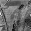
Oblique aerial view centred on the cropmarks of the Roman Temporary Camp, linear features, enclosure, pits and rig at Gilrivie with the farmstead adjacent, looking to the NW. |
5/7/1982 |
Item Level |
|
 |
On-line Digital Images |
SC 1013530 |
Records of Aberdeen Aerial Surveys, Aberdeen, Scotland |
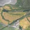
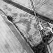
Oblique aerial view centred on the cropmarks of the enclosure, barrow, linear features, pits and rig with the farm adjacent at Gilrivie, looking to the SSE. |
8/7/1982 |
Item Level |
|
 |
On-line Digital Images |
SC 1013531 |
Records of Aberdeen Aerial Surveys, Aberdeen, Scotland |
Oblique aerial view centred on the cropmarks of the enclosures, barrow, linear features, pits and rig with the farm adjacent at Gilrivie and Broomley, looking to the SE. |
8/7/1982 |
Item Level |
|
 |
On-line Digital Images |
SC 1013532 |
Records of Aberdeen Aerial Surveys, Aberdeen, Scotland |
Oblique aerial view centred on the cropmarks of the enclosure, linear features, Roman temporary camp, pits and rig with the farm adjacent at Gilrivie and Dun, looking to the ESE. |
8/7/1982 |
Item Level |
|
 |
On-line Digital Images |
SC 1013533 |
Records of Aberdeen Aerial Surveys, Aberdeen, Scotland |
Oblique aerial view centred on the cropmarks of the linear features, Roman temporary camp, pits and rig with the farm adjacent at Gilrivie and Dun, looking to the ESE. |
8/7/1982 |
Item Level |
|
|
Photographs and Off-line Digital Images |
E 11341 |
RCAHMS Aerial Photography |
Oblique aerial view centred on the cropmarks of the enclosure, pits, rig and ring-ditch, with the farmhouse and farmsteading adjacent, taken from the WNW. |
3/8/2001 |
Item Level |
|
|
Photographs and Off-line Digital Images |
E 11343 |
RCAHMS Aerial Photography |
Oblique aerial view centred on the cropmarks of the enclosure, pits, rig and ring-ditch, with the farmhouse and farmsteading adjacent, taken from the SW. |
3/8/2001 |
Item Level |
|
|
Photographs and Off-line Digital Images |
E 11346 |
RCAHMS Aerial Photography |
Oblique aerial view centred on the cropmarks of the enclosure, pits, rig and ring-ditches, with the farmhouse and farmsteading adjacent, taken from the ENE. |
3/8/2001 |
Item Level |
|
|
Photographs and Off-line Digital Images |
E 11348 |
RCAHMS Aerial Photography |
Oblique aerial view centred on the cropmarks of the enclosure, barrow and rig, with the cropmarks of the enclosure, pits, rig and ring-ditch and the farmhouse and farmsteading adjacent, taken from the NW. |
3/8/2001 |
Item Level |
|
|
Photographs and Off-line Digital Images |
H 84952 CS |
RCAHMS Aerial Photography |
Oblique aerial view centred on the cropmarks of the enclosure, barrow and rig, with the cropmarks of the enclosure, pits, rig and ring-ditch and the farmhouse and farmsteading adjacent, taken from the WSW. |
3/8/2001 |
Item Level |
|
|
Photographs and Off-line Digital Images |
H 84956 CS |
RCAHMS Aerial Photography |
Oblique aerial view centred on the cropmarks of the enclosure, pits, rig and ring-ditch, with the farmhouse and farmsteading adjacent, taken from the SW. |
3/8/2001 |
Item Level |
|
|
Photographs and Off-line Digital Images |
H 84957 CS |
RCAHMS Aerial Photography |
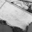
General oblique aerial view centred on the cropmarks of the enclosure, pits, rig and ring-ditches, with the farmhouse and farmsteading adjacent, taken from the S. |
3/8/2001 |
Item Level |
|
 |
On-line Digital Images |
DP 166948 |
RCAHMS Aerial Photography Digital |
Oblique aerial view centred on the cropmarks at Gilrivie, looking S. |
18/7/2013 |
Item Level |
|
 |
On-line Digital Images |
DP 166950 |
RCAHMS Aerial Photography Digital |
Oblique aerial view centred on the cropmarks at Gilrivie, looking SE. |
18/7/2013 |
Item Level |
|
 |
On-line Digital Images |
DP 166953 |
RCAHMS Aerial Photography Digital |
Oblique aerial view centred on the cropmarks at Gilrivie, looking ENE. |
18/7/2013 |
Item Level |
|
 |
On-line Digital Images |
SC 1721769 |
RCAHMS Aerial Photography |
Oblique aerial view centred on the cropmarks of the enclosure, barrow and rig, with the cropmarks of the enclosure, pits, rig and ring-ditch and the farmhouse and farmsteading adjacent, taken from the NW. |
3/8/2001 |
Item Level |
|
 |
On-line Digital Images |
SC 1721913 |
RCAHMS Aerial Photography |
Oblique aerial view centred on the cropmarks of the enclosure, pits, rig and ring-ditch, with the farmhouse and farmsteading adjacent, taken from the WNW. |
3/8/2001 |
Item Level |
|
 |
On-line Digital Images |
SC 1721914 |
RCAHMS Aerial Photography |
Oblique aerial view centred on the cropmarks of the enclosure, pits, rig and ring-ditch, with the farmhouse and farmsteading adjacent, taken from the SW. |
3/8/2001 |
Item Level |
|
 |
On-line Digital Images |
SC 1721915 |
RCAHMS Aerial Photography |
Oblique aerial view centred on the cropmarks of the enclosure, pits, rig and ring-ditches, with the farmhouse and farmsteading adjacent, taken from the ENE. |
3/8/2001 |
Item Level |
|


