
Following the launch of trove.scot in February 2025 we are now planning the retiral of some of our webservices. Canmore will be switched off on 24th June 2025. Information about the closure can be found on the HES website: Retiral of HES web services | Historic Environment Scotland
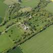
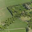
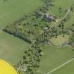
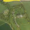
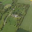
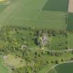
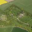
House Of Dun, Walled Garden And House


Walled Garden (Period Unassigned)
Site Name House Of Dun, Walled Garden And House
Classification Walled Garden (Period Unassigned)
Alternative Name(s) House Of Dun Policies
Canmore ID 219629
Site Number NO65NE 61.02
NGR NO 66749 59951
NGR Description Centred NO 66749 59951
Datum OSGB36 - NGR
Permalink http://canmore.org.uk/site/219629


- Council Angus
- Parish Dun
- Former Region Tayside
- Former District Angus
- Former County Angus
NO65NE 61.02 centred NO 66749 59951
Extends onto map sheet NO66SE.
Project (14 January 2013 - 18 January 2013)
NO 66749 59951 A geophysical survey was carried out, 14–18 January 2013, within the W walled garden and the burial ground of the House of Dun. Gradiometer and resistance surveys were undertaken over all available areas in the garden with the aim of locating any surviving garden features and possible structural remains associated with the postulated earlier castle. Resistance survey was also undertaken around the mausoleum in the graveyard immediately to the S of the walled garden with the aim of identifying the earlier church. The mausoleum was created from earlier church remains.
The survey in the garden detected numerous anomalies. A low resistance anomaly suggestive of a robber trench or ditch was detected which may indicate the location of an earlier wall, or possibly an earlier smaller walled garden. A perplexing cluster of high resistance anomalies was also detected. These have a circular form and may indicate an earlier garden feature. Several linear anomalies have been detected indicating former paths. The gradiometer survey recorded an extremely high level of magnetic noise across the majority of the site. While these responses may reflect natural features, their form suggests they were probably caused by imported material used to level the garden.
The survey of the burial ground detected a well defined rectilinear anomaly indicating a western extension to the extant mausoleum. The data suggest the earlier church was the same width as the current structure, but twice the length.
Archive: Rose Geophysical Consultants
Funder: The National Trust for Scotland
Susan Ovenden, Rose Geophysical Consultants, 2013
(Source: DES)
Earth Resistance Survey (14 January 2013 - 18 January 2013)
NO 66749 59951 Resistance survey.
Archive: Rose Geophysical Consultants
Funder: The National Trust for Scotland
Susan Ovenden, Rose Geophysical Consultants, 2013
(Source: DES)
Magnetometry (14 January 2013 - 18 January 2013)
NO 66749 59951 Magnetometry survey.
Archive: Rose Geophysical Consultants
Funder: The National Trust for Scotland
Susan Ovenden, Rose Geophysical Consultants, 2013
(Source: DES)
Excavation (5 July 2014 - 25 July 2014)
NO 66749 59951 A second season of excavation was undertaken, 5–25 July 2014, at the site of the medieval Castle of Dun. The excavation was conducted as part of the National Trust for Scotland’s Trail Blazer youth camps. Four trenches were excavated and uncovered large foundations believed to be those of the medieval castle and a large ditch which may
relate to some enclosing works or earlier defences.
Archive: The National Trust for Scotland and RCAHMS (intended)
Funder: The National Trust for Scotland
Daniel Rhodes - The National Trust for Scotland
(Source: DES)
Excavation (12 August 2016 - 19 August 2016)
NO 66749 59951 A third season of excavation was carried out, 12–19 August 2016, as part of the National Trust for Scotland Trail Blazer young person volunteer scheme. The excavation uncovered further evidence of substantial stonebuilt structures in the form of in situ foundations in an
area adjacent to the medieval Chapel of Dun, and these are believed to be the remains of the Erskine Castle of Dun.
Archive: The National Trust for Scotland
Funder: The National Trust for Scotland
Daniel Rhodes – The National Trust for Scotland
(Source: DES)
Excavation (12 August 2017 - 19 August 2017)
NO 66749 59951 (Canmore ID: 219629) A fourth season of excavation was carried out, 12–19 August 2017, as part of the National Trust for Scotland Trail Blazer young person volunteer scheme. The excavation uncovered further evidence of substantial stone-built structures in the form of in situ foundations of a possible stair tower in an area adjacent to the medieval Chapel of Dun and believed to be the remains of the Erskine Castle of Dun.
Achive: National Trust for Scotland
Funder: National Trust for Scotland
Daniel Rhodes - National Trust for Scotland
(Source: DES, Volume 18)

