Accessibility

Font Size

100% 150% 200%

Background Colour

Default Contrast
Close Reset

Affleck, Home Farm

Farmstead (Period Unassigned), Horse Engine House (19th Century) - (20th Century)

Site Name Affleck, Home Farm

Classification Farmstead (Period Unassigned), Horse Engine House (19th Century) - (20th Century)

Alternative Name(s) Home Farm Of Affleck Castle

Canmore ID 219560

Site Number NO43NE 60.01

NGR NO 49309 38861

NGR Description Centred NO 49309 38861

Datum OSGB36 - NGR

Permalink http://canmore.org.uk/site/219560

Ordnance Survey licence number AC0000807262. All rights reserved.
Canmore Disclaimer. © Bluesky International Limited 2025. Public Sector Viewing Terms

Toggle Aerial | View on large map

Digital Images

General oblique aerial view of the Affleck Estate, centred on the castle, taken from the SE.
General oblique aerial view of the Affleck Estate, centred on the castle, taken from the SE.General oblique aerial view of the Affleck Estate, centred on the castle, taken from the E.General oblique aerial view of the Affleck Estate, centred on the castle, taken from the E.Oblique aerial view centred on Affleck Castle.Oblique aerial view of the country house and farmsteading, taken from the NW.Oblique aerial view centred on the country house with the tower-house adjacent, taken from the NW.Oblique aerial view centred on the country house with the tower-house adjacent, taken from the SW.General oblique aerial view of the Affleck Estate, centred on the castle, taken from the W.Oblique aerial view centred on Affleck Castle.Oblique aerial view of the tower-house, country house, farmsteading and horsemill, taken from the NW.Oblique aerial view centred on the country house with the tower-house adjacent, taken from the SSW.Affleck Castle and Home Farm, Monikie.  Oblique aerial photograph taken facing east.Oblique aerial view of the tower-house, country house, farmsteading and horsemill, taken from the WSW.Oblique aerial view of the tower-house, country house, farmsteading and horsemill, taken from the SW.Oblique aerial view of the country house and farmsteading, taken from the WSW.Oblique aerial view of the tower-house, country house, farmsteading and horsemill, taken from the SSE.Oblique aerial view of the tower-house, country house, farmsteading and horsemill, taken from the SE.Oblique aerial view of the tower-house, country house, farmsteading and horsemill, taken from the ESE.Oblique aerial view of the tower-house, country house, farmsteading and horsemill, taken from the NNE.Oblique aerial view centred on the country house with the tower-house adjacent, taken from the WSW.Affleck Castle and Home Farm, Monikie.  Oblique aerial photograph taken facing north-west.Oblique aerial view of the country house and farmsteading, taken from the SSW.General oblique aerial view of the Affleck Estate, centred on the castle, taken from the S.Oblique aerial view centred on the country house with the tower-house adjacent, taken from the SSE.General oblique aerial view of the Affleck Estate, centred on the castle, taken from the SSE.

Administrative Areas

  • Council Angus
  • Parish Monikie
  • Former Region Tayside
  • Former District Angus
  • Former County Angus

Archaeology Notes

NO43NE 60.01 centred 49308 38861

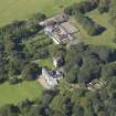
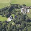
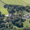
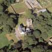
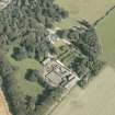
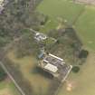
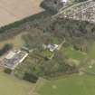
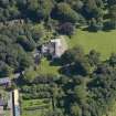
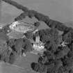
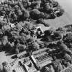
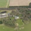
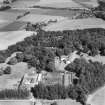
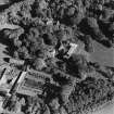
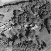
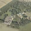
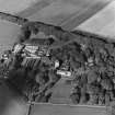
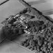
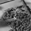
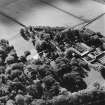
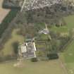
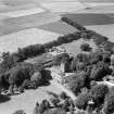
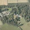
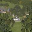
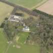
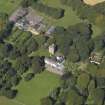
(Location cited as NO 4931 3886 and name as Affleck). The Home Farm of Affleck Castle is a large farmstead with a horsemill, still roofed, on the W side. It is situated on a gentle slope at an altitude of 165m OD and a variety of buildings have been added over the years.

Air photographs: AAS/02/6/G15/10-15 and AAS/02/6/CT/11-19, flown 20 June 2002.

NMRS, MS/712/108.

References

MyCanmore Image Contributions


Contribute an Image

MyCanmore Text Contributions