
Rum, Papadil


Promontory Fort (Prehistoric)
Site Name Rum, Papadil
Classification Promontory Fort (Prehistoric)
Alternative Name(s) Rhum
Canmore ID 21950
Site Number NM39SE 1
NGR NM 3614 9188
Datum OSGB36 - NGR
Permalink http://canmore.org.uk/site/21950


- Council Highland
- Parish Small Isles
- Former Region Highland
- Former District Lochaber
- Former County Inverness-shire
After a site visit, S Bardwell and S Dickenson were of the opinion that the wall was created by material thrown up from lazy beds and were not convinced of its status as a fort.
NMRS, MS/868/1.
Field Visit (May 1983)
Papadil NM 361 919 NM39SE
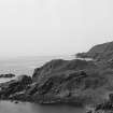
There are the remains of what has probably been a fort on a rocky ridge overlooking the sea about 450m SW of Papadil Lodge. A single wall crosses the NE end of the ridge and it continues intermittently down the SE flank to take in a sloping grassy terrace on the E. The wall is up to 2.5m thick and 0.3m high with stretches of the outer face visible on the NE; there are two entrances, situated on the NE and E respectively.
RCAHMS 1983, visited May 1983
Field Visit (12 October 2010)
This fort, occupying the highest point of a rocky ridge, is protected by sea cliffs on the NW and SW, and by steep slopes on the E. The easiest access was probably from the N, along the spine of the ridge which rises in a series of terraces. Here the approach is barred by a wall largely reduced to a band of rubble 2m thick, though the remains of an outer face can be traced, linking exposed (and apparently modified) outcrops and standing up to 0.6m high. The wall starts at the cliff edge at NM 36193 91963 and runs E for 5m before turning to the S, where it can be followed intermittently as a grass-grown rubble band linking outcrops, to reach the cliffs defining the S end of the fort at NM 36184 91874. The triangular area thus enclosed measures about 80m from N to S by up to 45m transversely. A gap in the wall immediately S of the NE corner may be an entrance. No structures were recorded within the fort.
Visited by RCAHMS (SDB, ARG) 12 October 2010.
Note (10 November 2014 - 23 May 2016)
What are probably the remains of a fort are situated on a promontory on the headland to the SW of Loch Papadil on the SW coast of the island of Rum. The defences comprise a wall about 2.5m in thickness which can be seen crossing the neck of the promontory on the NE, to drop down the slope on the E and extend along the SE flank, where the line of the outer face is intermittently visible; elsewhere the margin of the promontory falls away from a ragged cliff-edge into steep rocky slopes. The interior measures a maximum of 70m from NE to SW by 45m transversely (0.2ha), but it is featureless apart from evidence of lazy-bed cultivation. There are possible entrances on the NE and E.
Information from An Atlas of Hillforts of Great Britain and Ireland – 23 May 2016. Atlas of Hillforts SC2509

