
Millfield Farm


Farmstead (Period Unassigned)
Site Name Millfield Farm
Classification Farmstead (Period Unassigned)
Canmore ID 219129
Site Number NT63SE 54
NGR NT 65054 33163
Datum OSGB36 - NGR
Permalink http://canmore.org.uk/site/219129
Ordnance Survey licence number AC0000807262. All rights reserved.
Canmore Disclaimer.
© Bluesky International Limited 2025. Public Sector Viewing Terms
- Correction
- Favourite

SC 2115696
Estate Exchange. Mertoun. No 1492. Sale brochure
Collection of sale catalogues relating to Scottish estates
16/7/1912
© Courtesy of HES (Estates Exchange Collection)

SC 2115700
Estate Exchange. Mertoun. No 1492. Sale brochure
Collection of sale catalogues relating to Scottish estates
16/7/1912
© Courtesy of HES (Estates Exchange Collection)

SC 2115705
Estate Exchange. Mertoun. No 1492. Sale brochure
Collection of sale catalogues relating to Scottish estates
16/7/1912
© Courtesy of HES (Estates Exchange Collection)

SC 2115709
Estate Exchange. Mertoun. No 1492. Sale brochure
Collection of sale catalogues relating to Scottish estates
16/7/1912
© Courtesy of HES (Estates Exchange Collection)

SC 2115721
Estate Exchange. Mertoun. No 1492. Sale brochure
Collection of sale catalogues relating to Scottish estates
16/7/1912
© Courtesy of HES (Estates Exchange Collection)

SC 2115723
Estate Exchange. Mertoun. No 1492. Sale brochure
Collection of sale catalogues relating to Scottish estates
16/7/1912
© Courtesy of HES (Estates Exchange Collection)

SC 2115732
Estate Exchange. Mertoun. No 1492. Sale brochure
Collection of sale catalogues relating to Scottish estates
16/7/1912
© Courtesy of HES (Estates Exchange Collection)

SC 2115734
Estate Exchange. Mertoun. No 1492. Sale brochure
Collection of sale catalogues relating to Scottish estates
16/7/1912
© Courtesy of HES (Estates Exchange Collection)

SC 2115735
Estate Exchange. Mertoun. No 1492. Sale brochure
Collection of sale catalogues relating to Scottish estates
16/7/1912
© Courtesy of HES (Estates Exchange Collection)

SC 2115740
Estate Exchange. Mertoun. No 1492. Sale brochure
Collection of sale catalogues relating to Scottish estates
16/7/1912
© Courtesy of HES (Estates Exchange Collection)

SC 2115742
Estate Exchange. Mertoun. No 1492. Sale brochure
Collection of sale catalogues relating to Scottish estates
16/7/1912
© Courtesy of HES (Estates Exchange Collection)

SC 2115743
Estate Exchange. Mertoun. No 1492. Sale brochure
Collection of sale catalogues relating to Scottish estates
16/7/1912
© Courtesy of HES (Estates Exchange Collection)

SC 2115744
Estate Exchange. Mertoun. No 1492. Sale brochure
Collection of sale catalogues relating to Scottish estates
16/7/1912
© Courtesy of HES (Estates Exchange Collection)

SC 2115678
Estate Exchange. Mertoun. No 1492. Sale brochure
Collection of sale catalogues relating to Scottish estates
16/7/1912
© Courtesy of HES (Estates Exchange Collection)

SC 2115682
Estate Exchange. Mertoun. No 1492. Sale brochure
Collection of sale catalogues relating to Scottish estates
16/7/1912
© Courtesy of HES (Estates Exchange Collection)

SC 2115685
Estate Exchange. Mertoun. No 1492. Sale brochure
Collection of sale catalogues relating to Scottish estates
16/7/1912
© Courtesy of HES (Estates Exchange Collection)

SC 2115704
Estate Exchange. Mertoun. No 1492. Sale brochure
Collection of sale catalogues relating to Scottish estates
16/7/1912
© Courtesy of HES (Estates Exchange Collection)

SC 2115706
Estate Exchange. Mertoun. No 1492. Sale brochure
Collection of sale catalogues relating to Scottish estates
16/7/1912
© Courtesy of HES (Estates Exchange Collection)

SC 2115707
Estate Exchange. Mertoun. No 1492. Sale brochure
Collection of sale catalogues relating to Scottish estates
16/7/1912
© Courtesy of HES (Estates Exchange Collection)

SC 2115712
Estate Exchange. Mertoun. No 1492. Sale brochure
Collection of sale catalogues relating to Scottish estates
16/7/1912
© Courtesy of HES (Estates Exchange Collection)

SC 2115719
Estate Exchange. Mertoun. No 1492. Sale brochure
Collection of sale catalogues relating to Scottish estates
16/7/1912
© Courtesy of HES (Estates Exchange Collection)

SC 2115722
Estate Exchange. Mertoun. No 1492. Sale brochure
Collection of sale catalogues relating to Scottish estates
16/7/1912
© Courtesy of HES (Estates Exchange Collection)

SC 2115724
Estate Exchange. Mertoun. No 1492. Sale brochure
Collection of sale catalogues relating to Scottish estates
16/7/1912
© Courtesy of HES (Estates Exchange Collection)

SC 2115739
Estate Exchange. Mertoun. No 1492. Sale brochure
Collection of sale catalogues relating to Scottish estates
16/7/1912
© Courtesy of HES (Estates Exchange Collection)

SC 2115679
Estate Exchange. Mertoun. No 1492. Sale brochure
Collection of sale catalogues relating to Scottish estates
16/7/1912
© Courtesy of HES (Estates Exchange Collection)

SC 2115689
Estate Exchange. Mertoun. No 1492. Sale brochure
Collection of sale catalogues relating to Scottish estates
16/7/1912
© Courtesy of HES (Estates Exchange Collection)

SC 2115692
Estate Exchange. Mertoun. No 1492. Sale brochure
Collection of sale catalogues relating to Scottish estates
16/7/1912
© Courtesy of HES (Estates Exchange Collection)

SC 2115698
Estate Exchange. Mertoun. No 1492. Sale brochure
Collection of sale catalogues relating to Scottish estates
16/7/1912
© Courtesy of HES (Estates Exchange Collection)

SC 2115717
Estate Exchange. Mertoun. No 1492. Sale brochure
Collection of sale catalogues relating to Scottish estates
16/7/1912
© Courtesy of HES (Estates Exchange Collection)

SC 2115733
Estate Exchange. Mertoun. No 1492. Sale brochure
Collection of sale catalogues relating to Scottish estates
16/7/1912
© Courtesy of HES (Estates Exchange Collection)

SC 2115736
Estate Exchange. Mertoun. No 1492. Sale brochure
Collection of sale catalogues relating to Scottish estates
16/7/1912
© Courtesy of HES (Estates Exchange Collection)

SC 2115675
Estate Exchange. Mertoun. No 1492. Sale brochure
Collection of sale catalogues relating to Scottish estates
16/7/1912
© Courtesy of HES (Estates Exchange Collection)

SC 2115676
Estate Exchange. Mertoun. No 1492. Sale brochure
Collection of sale catalogues relating to Scottish estates
16/7/1912
© Courtesy of HES (Estates Exchange Collection)

SC 2115681
Estate Exchange. Mertoun. No 1492. Sale brochure
Collection of sale catalogues relating to Scottish estates
16/7/1912
© Courtesy of HES (Estates Exchange Collection)

SC 2115683
Estate Exchange. Mertoun. No 1492. Sale brochure
Collection of sale catalogues relating to Scottish estates
16/7/1912
© Courtesy of HES (Estates Exchange Collection)

SC 2115693
Estate Exchange. Mertoun. No 1492. Sale brochure
Collection of sale catalogues relating to Scottish estates
16/7/1912
© Courtesy of HES (Estates Exchange Collection)

SC 2115710
Estate Exchange. Mertoun. No 1492. Sale brochure
Collection of sale catalogues relating to Scottish estates
16/7/1912
© Courtesy of HES (Estates Exchange Collection)

SC 2115687
Estate Exchange. Mertoun. No 1492. Sale brochure
Collection of sale catalogues relating to Scottish estates
16/7/1912
© Courtesy of HES (Estates Exchange Collection)

SC 2115691
Estate Exchange. Mertoun. No 1492. Sale brochure
Collection of sale catalogues relating to Scottish estates
16/7/1912
© Courtesy of HES (Estates Exchange Collection)

SC 2115695
Estate Exchange. Mertoun. No 1492. Sale brochure
Collection of sale catalogues relating to Scottish estates
16/7/1912
© Courtesy of HES (Estates Exchange Collection)

SC 2115714
Estate Exchange. Mertoun. No 1492. Sale brochure
Collection of sale catalogues relating to Scottish estates
16/7/1912
© Courtesy of HES (Estates Exchange Collection)

SC 2115715
Estate Exchange. Mertoun. No 1492. Sale brochure
Collection of sale catalogues relating to Scottish estates
16/7/1912
© Courtesy of HES (Estates Exchange Collection)

SC 2115716
Estate Exchange. Mertoun. No 1492. Sale brochure
Collection of sale catalogues relating to Scottish estates
16/7/1912
© Courtesy of HES (Estates Exchange Collection)

SC 2115728
Estate Exchange. Mertoun. No 1492. Sale brochure
Collection of sale catalogues relating to Scottish estates
16/7/1912
© Courtesy of HES (Estates Exchange Collection)

SC 2115680
Estate Exchange. Mertoun. No 1492. Sale brochure
Collection of sale catalogues relating to Scottish estates
16/7/1912
© Courtesy of HES (Estates Exchange Collection)

SC 2115688
Estate Exchange. Mertoun. No 1492. Sale brochure
Collection of sale catalogues relating to Scottish estates
16/7/1912
© Courtesy of HES (Estates Exchange Collection)

SC 2115697
Estate Exchange. Mertoun. No 1492. Sale brochure
Collection of sale catalogues relating to Scottish estates
16/7/1912
© Courtesy of HES (Estates Exchange Collection)

SC 2115701
Estate Exchange. Mertoun. No 1492. Sale brochure
Collection of sale catalogues relating to Scottish estates
16/7/1912
© Courtesy of HES (Estates Exchange Collection)

SC 2115708
Estate Exchange. Mertoun. No 1492. Sale brochure
Collection of sale catalogues relating to Scottish estates
16/7/1912
© Courtesy of HES (Estates Exchange Collection)

SC 2115718
Estate Exchange. Mertoun. No 1492. Sale brochure
Collection of sale catalogues relating to Scottish estates
16/7/1912
© Courtesy of HES (Estates Exchange Collection)

SC 2115726
Estate Exchange. Mertoun. No 1492. Sale brochure
Collection of sale catalogues relating to Scottish estates
16/7/1912
© Courtesy of HES (Estates Exchange Collection)

SC 2115730
Estate Exchange. Mertoun. No 1492. Sale brochure
Collection of sale catalogues relating to Scottish estates
16/7/1912
© Courtesy of HES (Estates Exchange Collection)

SC 2115731
Estate Exchange. Mertoun. No 1492. Sale brochure
Collection of sale catalogues relating to Scottish estates
16/7/1912
© Courtesy of HES (Estates Exchange Collection)

SC 2115741
Estate Exchange. Mertoun. No 1492. Sale brochure
Collection of sale catalogues relating to Scottish estates
16/7/1912
© Courtesy of HES (Estates Exchange Collection)

SC 2115690
Estate Exchange. Mertoun. No 1492. Sale brochure
Collection of sale catalogues relating to Scottish estates
16/7/1912
© Courtesy of HES (Estates Exchange Collection)

SC 2115702
Estate Exchange. Mertoun. No 1492. Sale brochure
Collection of sale catalogues relating to Scottish estates
16/7/1912
© Courtesy of HES (Estates Exchange Collection)

SC 2115703
Estate Exchange. Mertoun. No 1492. Sale brochure
Collection of sale catalogues relating to Scottish estates
16/7/1912
© Courtesy of HES (Estates Exchange Collection)

SC 2115725
Estate Exchange. Mertoun. No 1492. Sale brochure
Collection of sale catalogues relating to Scottish estates
16/7/1912
© Courtesy of HES (Estates Exchange Collection)

SC 2115727
Estate Exchange. Mertoun. No 1492. Sale brochure
Collection of sale catalogues relating to Scottish estates
16/7/1912
© Courtesy of HES (Estates Exchange Collection)

SC 2115737
Estate Exchange. Mertoun. No 1492. Sale brochure
Collection of sale catalogues relating to Scottish estates
16/7/1912
© Courtesy of HES (Estates Exchange Collection)

SC 2115738
Estate Exchange. Mertoun. No 1492. Sale brochure
Collection of sale catalogues relating to Scottish estates
16/7/1912
© Courtesy of HES (Estates Exchange Collection)

SC 2115745
Estate Exchange. Mertoun. No 1492. Sale brochure
Collection of sale catalogues relating to Scottish estates
16/7/1912
© Courtesy of HES (Estates Exchange Collection)

SC 2115746
Estate Exchange. Mertoun. No 1492. Sale brochure
Collection of sale catalogues relating to Scottish estates
16/7/1912
© Courtesy of HES (Estates Exchange Collection)

SC 2115677
Estate Exchange. Mertoun. No 1492. Sale brochure
Collection of sale catalogues relating to Scottish estates
16/7/1912
© Courtesy of HES (Estates Exchange Collection)

SC 2115684
Estate Exchange. Mertoun. No 1492. Sale brochure
Collection of sale catalogues relating to Scottish estates
16/7/1912
© Courtesy of HES (Estates Exchange Collection)

SC 2115686
Estate Exchange. Mertoun. No 1492. Sale brochure
Collection of sale catalogues relating to Scottish estates
16/7/1912
© Courtesy of HES (Estates Exchange Collection)

SC 2115694
Estate Exchange. Mertoun. No 1492. Sale brochure
Collection of sale catalogues relating to Scottish estates
16/7/1912
© Courtesy of HES (Estates Exchange Collection)

SC 2115699
Estate Exchange. Mertoun. No 1492. Sale brochure
Collection of sale catalogues relating to Scottish estates
16/7/1912
© Courtesy of HES (Estates Exchange Collection)

SC 2115711
Estate Exchange. Mertoun. No 1492. Sale brochure
Collection of sale catalogues relating to Scottish estates
16/7/1912
© Courtesy of HES (Estates Exchange Collection)

SC 2115713
Estate Exchange. Mertoun. No 1492. Sale brochure
Collection of sale catalogues relating to Scottish estates
16/7/1912
© Courtesy of HES (Estates Exchange Collection)

SC 2115720
Estate Exchange. Mertoun. No 1492. Sale brochure
Collection of sale catalogues relating to Scottish estates
16/7/1912
© Courtesy of HES (Estates Exchange Collection)

SC 2115729
Estate Exchange. Mertoun. No 1492. Sale brochure
Collection of sale catalogues relating to Scottish estates
16/7/1912
© Courtesy of HES (Estates Exchange Collection)

- Council Scottish Borders, The
- Parish Mertoun
- Former Region Borders
- Former District Ettrick And Lauderdale
- Former County Berwickshire
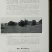
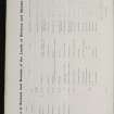
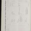
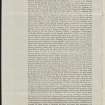
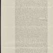
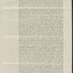
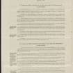
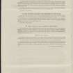
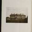
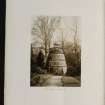
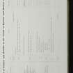
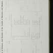
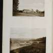
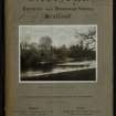
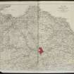
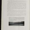
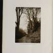
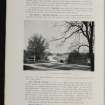
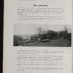
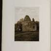
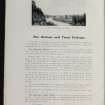
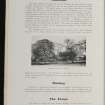
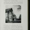
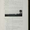
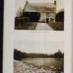
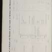
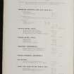
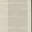
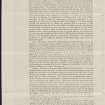
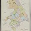
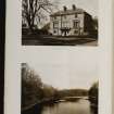
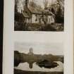
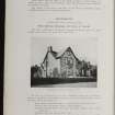
An early twentieth-century sales brochure gives a detailed account of the buildings which made up Millfield Farm on the Mertoun Estate.
The farmhouse was two storeys high, while the steading consisted of a range of buildings laid out around two open cattle courts. These buildings included a turnip shed, a byre, a straw barn, a granary and stabling for six horses. Farm cottages provided accommodation for two farm workers.
Millfield must also have possessed water-powered facilities, probably for threshing purposes. Map evidence from the late nineteenth century to the present shows both a mill dam, and a system of water channels or lades.
Text prepared by RCAHMS as part of the Accessing Scotland's Past project

