Accessibility

Font Size

100% 150% 200%

Background Colour

Default Contrast
Close Reset

The Haining, Stables

Stable(S) (19th Century)

Site Name The Haining, Stables

Classification Stable(S) (19th Century)

Canmore ID 218548

Site Number NT42NE 23.03
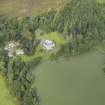
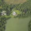
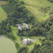
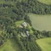
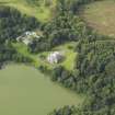
NGR NT 46810 28021

Datum OSGB36 - NGR

Permalink http://canmore.org.uk/site/218548

Ordnance Survey licence number AC0000807262. All rights reserved.
Canmore Disclaimer. © Bluesky International Limited 2025. Public Sector Viewing Terms

Toggle Aerial | View on large map

Digital Images

Oblique aerial view centred on the country house with the stable block adjacent, taken from the WSW.
Oblique aerial view centred on the country house with the stable block adjacent, taken from the WSW.South range. View of horse stall painted decoration.North range from south west.South range from north east.South range from south east.Oblique aerial view centred on the country house with the stable block adjacent, taken from the SSE.Oblique aerial view centred on the country house with the stable block adjacent, taken from the SSE.Oblique aerial view centred on the country house with the stable block adjacent, taken from the ENE.Sketch plan and elevation of stables, The Haining.North range from north.Oblique aerial view centred on the country house with the stable block adjacent, taken from the SSW.Oblique aerial view centred on the country house with the stable block adjacent, taken from the S.Oblique aerial view centred on the country house with the stable block adjacent, taken from the ESE.North range from west.West range from east.North range from north east.The Haining; stable loggia from SEView from SW.North range from south west.West range from east.South range from north.South range. South front. Detail of carved festoons.The Haining; entrance to stable squareOblique aerial view centred on the country house with the stable block adjacent, taken from the W.Oblique aerial view centred on the country house with the stable block adjacent, taken from the NNW.Detail of 'Grooms Bell' sign.North range from south east.Oblique aerial view centred on the country house with the stable block adjacent, taken from the WNW.Oblique aerial view centred on the country house with the stable block adjacent, taken from the N.North range from south.North range from south west.South range from south west.Oblique aerial view centred on the country house with the stable block adjacent, taken from the SW.The Haining; stable loggia from SEThe Haining; entrance to stable squareSketch of elevations and details of stables, The Haining.South range. Horse stalls.North range from south west.North range from north west.South range from south east.South range from south west.View of arched entrance.Oblique aerial view centred on the country house with the stable block adjacent, taken from the SE.South range. Horse stalls.Detail of entrance and pillars.

Administrative Areas

  • Council Scottish Borders, The
  • Parish Selkirk
  • Former Region Borders
  • Former District Ettrick And Lauderdale
  • Former County Selkirkshire

Threatened Building Survey Programme 2013-14 (22 August 2012 - 27 September 2013)

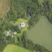
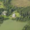
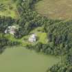
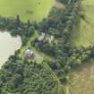
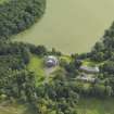
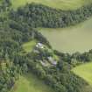
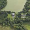
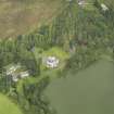
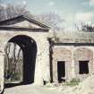
Possibly built to the designs of Archibald Elliot as part of the redsign of the house in the 1820's. Constructed in two ranges, one south facing range with a curved frontage overlooking the lake. The other U-shpaed range forms the courtyard shape of the stables. The north entrance is severe doric with a carved skull of a horse on the the keystone above the arch.

Activities

Photographic Survey (22 August 2012 - 27 September 2013)

Photographed for the Threatened Buildings Survey prior and post restoration 2012-13.

Sbc Note

Visibility: This is an upstanding building.

Information from Scottish Borders Council.

References

MyCanmore Image Contributions


Contribute an Image

MyCanmore Text Contributions