
Following the launch of trove.scot in February 2025 we are now planning the retiral of some of our webservices. Canmore will be switched off on 24th June 2025. Information about the closure can be found on the HES website: Retiral of HES web services | Historic Environment Scotland
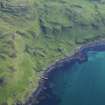
Mull, Calgary, Cruach Sleibhe


Corn Drying Kiln (Medieval) - (18th Century)(Possible), Horizontal Mill (Medieval) - (18th Century)(Possible), Township (Medieval) - (18th Century)
Site Name Mull, Calgary, Cruach Sleibhe
Classification Corn Drying Kiln (Medieval) - (18th Century)(Possible), Horizontal Mill (Medieval) - (18th Century)(Possible), Township (Medieval) - (18th Century)
Alternative Name(s) Inivea
Canmore ID 21842
Site Number NM35SE 26
NGR NM 3680 5180
NGR Description Centred on NM 3680 5180
Datum OSGB36 - NGR
Permalink http://canmore.org.uk/site/21842


- Council Argyll And Bute
- Parish Kilninian And Kilmore
- Former Region Strathclyde
- Former District Argyll And Bute
- Former County Argyll
NM35SE 26 centred on 3680 5180
(Centred NM 3685 5180) Unnamed detail shown.
OS 1:10,000 map, (1976)
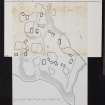
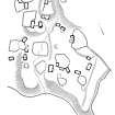
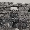
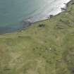
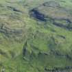
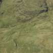
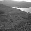
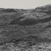
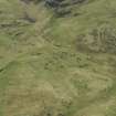
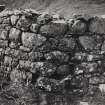
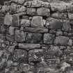
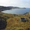
Inivea Township, Calgary. This township is situated on the lower slopes of Cruach Sleibhe at a height of about 75m OD. The remains of about two dozen buildings and associated enclosures can be identified, several of the houses being preserved to wall-head level. The buildings are for the most part grouped in twos and threes, and occupy patches of comparatively level ground, the majority of the dwelling-houses being built on a NE-SW axis, while the barns, which can usually be identified by the opposed winnowing-doors in the centre of their side-walls, are in most cases set at right angles to the prevailing wind. The associated enclosures, which probably served as kail-yards, vary a good deal in size and shape. The unnamed burn that flows through the township falls into a small pool ('a' on RCAHMS {1980} plan, q.v.) the mouth of which may have been enclosed to form the lower chamber of a horizontal mill. All the surviving buildings of the township appear to be of 18th-or early 19th-century date.
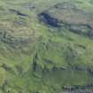
The main area of arable cultivation appears to have been on a broad shelf lying immediately above the township and extending eastward for some 500m. Here there may be seen considerable traces of rig-cultivation, and what appear to be the remains of a corn-drying kiln.
Pont's map of the late 16th century records the existence of a farm or township at 'Inue'; the lands of 'Imvie' are referred to about 1670, and the name is given as 'Inive' in 1739. By the last quarter of the 18th century the township seems to have become absorbed within the neighbouring farm of Frachadil and it is not mentioned by name in the census of the Argyll estates made in 1779 or on Langlands's map of 1801. In 1817 the property came into the hands of Capt Allan McAskill of Mornish and local tradition avers that the inhabitants of the township were evicted by this proprietor.
RCAHMS 1980, visited 1974
Nineteen unroofed buildings, one of which has two compartments, and two enclosures are depicted on the 1st edition of the OS 6-inch map (Argyllshire, Island of Mull 1882, sheet li). Fifteen unroofed buildings and three enclosures are shown on the current edition of the OS 1:10000 map (1976).
Information from RCAHMS (SAH) 9 June 1998
To the N of this site, as depicted on the 1st edition of the OS 6-inch map (Argyllshire, Island of Mull 1882, sheet li), is a head-dyke system.
Information from RCAHMS (SAH) 14 May 1999

