
Pricing Change
New pricing for orders of material from this site will come into place shortly. Charges for supply of digital images, digitisation on demand, prints and licensing will be altered.
Swinton, The Green, General


Green (Period Unassigned)
Site Name Swinton, The Green, General
Classification Green (Period Unassigned)
Canmore ID 218365
Site Number NT84NW 41
NGR NT 83500 47414
Datum OSGB36 - NGR
Permalink http://canmore.org.uk/site/218365


- Council Scottish Borders, The
- Parish Swinton
- Former Region Borders
- Former District Berwickshire
- Former County Berwickshire
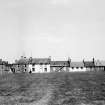
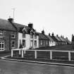
When the village of Swinton was rebuilt in the mid-eighteenth century, its houses were laid out in a formal plan around a central square, which incorporates a village green. It represents an early surviving example of a planned village in Scotland.
Fairs were once held on the green in June and October, and some evidence for these activities still survives. The market cross still stands there, and the presence of a socket stone, known as the 'Tron Stone', has also been recorded. This latter feature may once have formed part of a set of weighing scales.
Text prepared by RCAHMS as part of the Accessing Scotland's Past project
Photographic Survey (May 1962)
Photographic survey of buildings in Swinton village, Berwickshire, by the Scottish National Buildings Record in 1962

