
Fleet Canal, Cardoness Road Bridge


Road Bridge (Period Unknown)
Site Name Fleet Canal, Cardoness Road Bridge
Classification Road Bridge (Period Unknown)
Alternative Name(s) Gatehouse-of-fleet; River Fleet; Cardonness Road Bridge
Canmore ID 218079
Site Number NX55NE 29.01
NGR NX 59071 55131
Datum OSGB36 - NGR
Permalink http://canmore.org.uk/site/218079


- Council Dumfries And Galloway
- Parish Anwoth
- Former Region Dumfries And Galloway
- Former District Stewartry
- Former County Kirkcudbrightshire
NX55NE 29.01 59071 55131
Location formerly entered as NX 5906 5513.
This bridge, carrying a road over the canal, is clearly shown on the current edition of the OS 1:10000 map (1993).
Information from RCAHMS (MD), 11 July 2002.
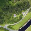
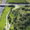
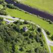
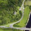
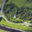
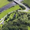
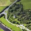
This bridge carries the present line of the A75 public road over the Fleet Canal to the S of Cardoness Castle (NX55NE 11). It is depicted, but not noted, on the 1993 edition of the OS 1:10,000 map.
Information from RCAHMS (RJCM), 22 March 2006.
Linear Account
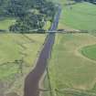
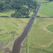
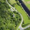
Fleet Canal - Lin 28. From NX 5953 5591 to NX 5868 5464.
History.
Although it had been possible to navigate the Water of Fleet from the sea up to Gatehouse prior to the canal era, nevertheless in 1824 a small scheme was undertaken to construct a canal. The purpose was to improve navigation as well as to achieve reclamation of land formerly covered over by the high tide. This new cut was carried out by men from Alexander Murray of Broughton's estates in Donegal who were in arrears of rent. He owned Cally Park which was situated on the E shore of the estuary. The waterway, which was 1,400 yards in length, was completed between 17 June and 3 October at a cost of #2,204.
J Lindsay 1968.
Summary.
(See map sheets NX55NE and NX55SE).
This canal (NX55NE 29.00) starts on map sheet NX55NE just S of Gatehouse of Fleet and heads SW towards Fleet Bay. On the 1st edition of the OS 6-inch map (Kirkcudbrightshire) a draw bridge (NX55NE 151) is clearly marked crossing the canal and on the current edition of the OS 1:10000 map (1993) a road bridge (NX55NE 29.01) traverses the waterway shortly before it leaves the map sheet.
The canal (NX55SE 41.00) terminates in Fleet Bay on map sheet NX55SE, with floodgates/sluice (NX55SE 41.01) being clearly marked at its termination on the 1st edition map.

