
Staffa, Meall Nan Gamhna


Cairn (Period Unassigned)
Site Name Staffa, Meall Nan Gamhna
Classification Cairn (Period Unassigned)
Alternative Name(s) Meall Nan Gambna
Canmore ID 21782
Site Number NM33NW 1
NGR NM 32427 35138
Datum OSGB36 - NGR
Permalink http://canmore.org.uk/site/21782


- Council Argyll And Bute
- Parish Kilninian And Kilmore
- Former Region Strathclyde
- Former District Argyll And Bute
- Former County Argyll
NM33NW 1 3236 3511
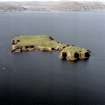
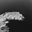
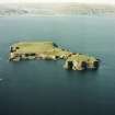
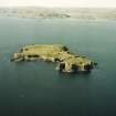
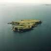
Meall nan Gamhna (NM 3236 3511), the highest point on Staffa, is surmounted by the usual cairn of stones.
D MacCulloch 1934.
NM 32 35 AOC (Scotland) Ltd was commissioned to undertake an archaeological survey of the lands controlled by the National Trust for Scotland on Staffa. The survey took place in late May and early April of 1996. Recorded sites are listed below. The full report of this survey has been deposited with both the local SMR and the NMRS.
Meall nan Gambna:
NM 3237 3513 Cairn.
NM 3236 3512 Triangulation point.
Sponsor: National Trust for Scotland
T Rees 1996.

